Property Record
36522 Coleman Rd, Magnolia, TX 77355

NEARBY LISTINGS FOR SALE OR LEASE
-
-
View all Magnolia listings for sale on LoopNet.com
Property Detail
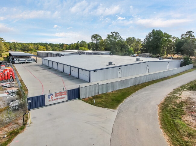
36522 Coleman Rd
0120-02-01502
Canfield Beckman
Commercialnec
A0120 - CANFIELD BECKMAN, TRACT 15-B, ACRES 0.9319
X
Montgomery
48339C0490G
Texas
2024
0.93 AC
2025
Outlying Montgomery Cnty
690300
Houston
24,000 SF
Houston-Pasadena-The Woodlands, TX
DEMOGRAPHICS near 36522 Coleman Rd
1 Mile
3 Mile
5 Mile
2024 Total Population
2,256
15,411
48,785
2029 Population
2,750
19,012
59,897
Pop Growth 2024-2029
+ 21.90%
+ 23.37%
+ 22.78%
Average Age
37
39
39
2024 Total Households
711
5,086
15,985
HH Growth 2024-2029
+ 22.22%
+ 23.48%
+ 22.93%
Median Household Inc
$49,930
$92,143
$95,434
Avg Household Size
3.00
2.90
3.00
2024 Avg HH Vehicles
2.00
2.00
2.00
Median Home Value
$169,230
$422,526
$382,224
Median Year Built
1991
2002
2003
Nearby Places
Map Layers
Map Styles
 Street
 Aerial
- Restaurants
- Banks
- Shops
- Fitness
- Groceries
PUBLIC TRANSPORTATION
AIRPORT
George Bush Intcntl/Houston
DRIVE
WALK
Distance
George Bush Intcntl/Houston
43 min
34.8 mi
Freight Ports
Port of Houston
DRIVE
WALK
Distance
Port of Houston
63 min
45.5 mi
SALE & LEASE HISTORY
LISTING DATE
SALE/LEASE

Oct 24, 2022
For Sale
Nearby Properties
Address
Land Use
TOTAL SIZE
Lot Size
Zoning
Address
Land Use
TOTAL SIZE
Lot Size
Zoning
150,000 SF
15 AC
Address
Land Use
TOTAL SIZE
Lot Size
Zoning
102,444 SF
15.14 AC
Address
Land Use
TOTAL SIZE
Lot Size
Zoning
108,038 SF
7.58 AC
Address
Land Use
TOTAL SIZE
Lot Size
Zoning
14,920 SF
49.96 AC
2
Address
Land Use
TOTAL SIZE
Lot Size
Zoning
32,624 SF
7.54 AC
Address
Land Use
TOTAL SIZE
Lot Size
Zoning
55,247 SF
10.38 AC
Address
Land Use
TOTAL SIZE
Lot Size
Zoning
1,200 SF
22.36 AC
2
Address
Land Use
TOTAL SIZE
Lot Size
Zoning
10.86 AC
Address
Land Use
TOTAL SIZE
Lot Size
Zoning
18.18 AC
2
Address
Land Use
TOTAL SIZE
Lot Size
Zoning
103,710 SF
7.50 AC
2
Address
Land Use
TOTAL SIZE
Lot Size
Zoning
68,950 SF
18.57 AC
2
Address
Land Use
TOTAL SIZE
Lot Size
Zoning
55,656 SF
5.09 AC
2
Address
Land Use
TOTAL SIZE
Lot Size
Zoning
48,444 SF
9.55 AC
Address
Land Use
TOTAL SIZE
Lot Size
Zoning
9,868 SF
7.55 AC
Address
Land Use
TOTAL SIZE
Lot Size
Zoning
5,353 SF
37.56 AC
Address
Land Use
TOTAL SIZE
Lot Size
Zoning
73,740 SF
9 AC
2
Address
Land Use
TOTAL SIZE
Lot Size
Zoning
52,800 SF
3.81 AC
2
Address
Land Use
TOTAL SIZE
Lot Size
Zoning
34,400 SF
5 AC
Address
Land Use
TOTAL SIZE
Lot Size
Zoning
44,301 SF
4.23 AC
2
Address
Land Use
TOTAL SIZE
Lot Size
Zoning
20,218 SF
7.32 AC
2
Address
Land Use
TOTAL SIZE
Lot Size
Zoning
13,260 SF
2.41 AC
2
Address
Land Use
TOTAL SIZE
Lot Size
Zoning
23,116 SF
7.62 AC
2
Address
Land Use
TOTAL SIZE
Lot Size
Zoning
8,320 SF
1.37 AC
Address
Land Use
TOTAL SIZE
Lot Size
Zoning
8,650 SF
1.19 AC
Address
Land Use
TOTAL SIZE
Lot Size
Zoning
37,296 SF
2.83 AC
2
Address
Land Use
TOTAL SIZE
Lot Size
Zoning
5,584 SF
1.18 AC
Address
Land Use
TOTAL SIZE
Lot Size
Zoning
18,544 SF
3.34 AC
2
Address
Land Use
TOTAL SIZE
Lot Size
Zoning
23,436 SF
4.03 AC
2
The World's #1 Commercial Real Estate Marketplace
Connect with us
© 2026 CoStar Group
The information above has been obtained from sources believed reliable. While we do not doubt its accuracy we have not verified it and make no guarantee, warranty or representation about it. It is your responsibility to independently confirm its accuracy and completeness. Any projections, opinions, assumptions, or estimates used are for example only and do not represent the current or future performance of the property. The value of this transaction to you depends on tax and other factors which should be evaluated by your tax, financial, and legal advisors. You and your advisors should conduct a careful, independent investigation of the property to determine to your satisfaction the suitability of the property for your needs.