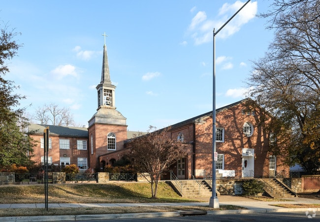
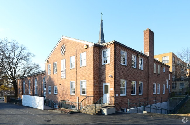
Property Record
3655 Calvert St Nw, Washington, DC 20007
Current Lease Availabilities
NEARBY LISTINGS FOR SALE OR LEASE
Property Detail
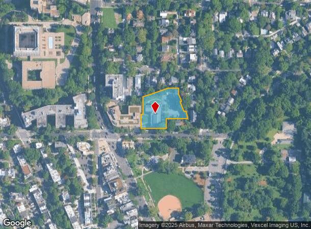
3655 Calvert St Nw
Washington-Arlington-Alexandria, DC-VA-MD-WV
Observatory Circle
1935-0818
SQUARE 1935 LOT 0818 NBHD: OBSERVATORY CIRCLE
Religious
District of Columbia
X
District of Columbia
1100010012C
818
0
1.10 AC
2025
Uptown
000400
Washington, DC
35,360 SF
DEMOGRAPHICS near 3655 Calvert St Nw
1 Mile
3 Mile
5 Mile
2024 Total Population
26,804
302,941
707,946
2029 Population
24,021
279,546
665,907
Pop Growth 2024-2029
(10.38%)
(7.72%)
(5.94%)
Average Age
41
38
38
2024 Total Households
13,816
151,224
335,671
HH Growth 2024-2029
(11.31%)
(8.49%)
(6.51%)
Median Household Inc
$127,276
$122,695
$122,084
Avg Household Size
1.90
1.90
2.00
2024 Avg HH Vehicles
1.00
1.00
1.00
Median Home Value
$938,829
$884,613
$840,257
Median Year Built
1950
1960
1964
Nearby Places
- Restaurants
- Banks
- Shops
- Fitness
- Groceries
PUBLIC TRANSPORTATION
COMMUTER RAIL
DRIVE
WALK
Distance
10 min
4.4 mi
DRIVE
WALK
Distance
11 min
4.5 mi
AIRPORT
Ronald Reagan Washington Ntl
DRIVE
WALK
Distance
Ronald Reagan Washington Ntl
17 min
6.7 mi
Washington Dulles International
DRIVE
WALK
Distance
Washington Dulles International
45 min
26.5 mi
Baltimore/Washington International Thurgood Marshall
DRIVE
WALK
Distance
Baltimore/Washington International Thurgood Marshall
54 min
34.2 mi
Freight Ports
Port of Baltimore
DRIVE
WALK
Distance
Port of Baltimore
61 min
39.5 mi
Nearby Properties
Address
Land Use
TOTAL SIZE
Lot Size
Zoning
Address
Land Use
TOTAL SIZE
Lot Size
Zoning
2,300,000 SF
1.60 AC
D-5-R
Address
Land Use
TOTAL SIZE
Lot Size
Zoning
533,778 SF
18.08 AC
UNZONED
Address
Land Use
TOTAL SIZE
Lot Size
Zoning
2,493,936 SF
8.99 AC
UNZONED
Address
Land Use
TOTAL SIZE
Lot Size
Zoning
2,455,000 SF
11.08 AC
MU-2
Address
Land Use
TOTAL SIZE
Lot Size
Zoning
52.44 AC
UNZONED
Address
Land Use
TOTAL SIZE
Lot Size
Zoning
1,100,000 SF
2.13 AC
D-6
Address
Land Use
TOTAL SIZE
Lot Size
Zoning
1,310,661 SF
3.38 AC
D-6
Address
Land Use
TOTAL SIZE
Lot Size
Zoning
1,738,573 SF
2.11 AC
D-7
Address
Land Use
TOTAL SIZE
Lot Size
Zoning
1.57 AC
D-5
Address
Land Use
TOTAL SIZE
Lot Size
Zoning
1,015,833 SF
1.60 AC
D-7
Address
Land Use
TOTAL SIZE
Lot Size
Zoning
553,914 SF
55.91 AC
R-1B
Address
Land Use
TOTAL SIZE
Lot Size
Zoning
1,185,122 SF
2.43 AC
D-6
Address
Land Use
TOTAL SIZE
Lot Size
Zoning
1,562,988 SF
15.33 AC
MU-10;MU-9
Address
Land Use
TOTAL SIZE
Lot Size
Zoning
1,214,044 SF
1.48 AC
D-6
Address
Land Use
TOTAL SIZE
Lot Size
Zoning
469,183 SF
1.20 AC
D-5
Address
Land Use
TOTAL SIZE
Lot Size
Zoning
626,543 SF
5.29 AC
UNZONED
Address
Land Use
TOTAL SIZE
Lot Size
Zoning
4.87 AC
D-6
Address
Land Use
TOTAL SIZE
Lot Size
Zoning
512,068 SF
1.36 AC
D-5-R
Address
Land Use
TOTAL SIZE
Lot Size
Zoning
787,000 SF
1.17 AC
D-7
Address
Land Use
TOTAL SIZE
Lot Size
Zoning
900,000 SF
12.60 AC
RA-4
Address
Land Use
TOTAL SIZE
Lot Size
Zoning
5.26 AC
UNZONED
Address
Land Use
TOTAL SIZE
Lot Size
Zoning
77.26 AC
R-3/GT
Address
Land Use
TOTAL SIZE
Lot Size
Zoning
636,768 SF
1.91 AC
C-O-ROSSLY
Address
Land Use
TOTAL SIZE
Lot Size
Zoning
247,900 SF
170.58 AC
RA-2;UNZON
Address
Land Use
TOTAL SIZE
Lot Size
Zoning
1,018,056 SF
1.14 AC
D-6
Address
Land Use
TOTAL SIZE
Lot Size
Zoning
776,520 SF
1.49 AC
MU-9B
Address
Land Use
TOTAL SIZE
Lot Size
Zoning
1,365,427 SF
2.62 AC
MU-9B;RA-4
Address
Land Use
TOTAL SIZE
Lot Size
Zoning
814,320 SF
0.99 AC
D-7
Address
Land Use
TOTAL SIZE
Lot Size
Zoning
499,000 SF
1.49 AC
RA-4
The World's #1 Commercial Real Estate Marketplace
Connect with us
© 2025 CoStar Group
The information above has been obtained from sources believed reliable. While we do not doubt its accuracy we have not verified it and make no guarantee, warranty or representation about it. It is your responsibility to independently confirm its accuracy and completeness. Any projections, opinions, assumptions, or estimates used are for example only and do not represent the current or future performance of the property. The value of this transaction to you depends on tax and other factors which should be evaluated by your tax, financial, and legal advisors. You and your advisors should conduct a careful, independent investigation of the property to determine to your satisfaction the suitability of the property for your needs.