Property Record
3668 W 102Nd St, Inglewood, CA 90303
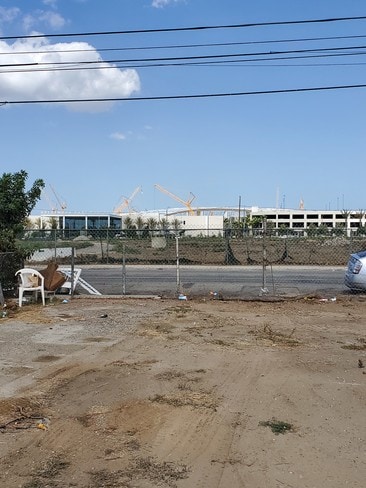

This Property Is For Sale
NEARBY LISTINGS FOR SALE OR LEASE
Property Detail
3668 W 102Nd St
Los Angeles-Long Beach-Glendale, CA
2464
4032-006-020
TRACT # 2464 LOT 8 BLK 9
Residentialacreage
Los Angeles
X
California
06037C1780G
8
2024
0.57 AC
2025
Inglewood/South LA
601900
Los Angeles
852 SF
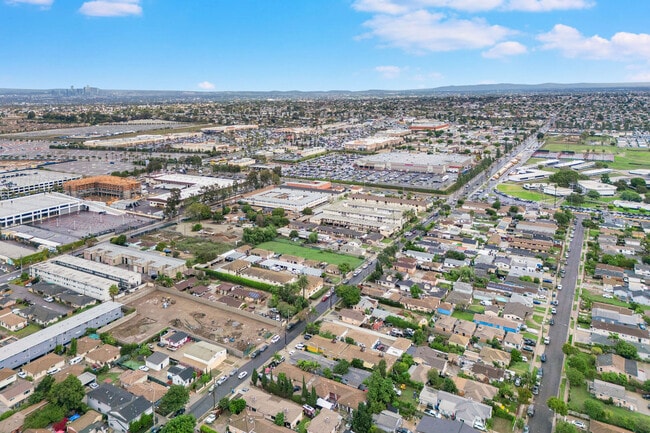
DEMOGRAPHICS near 3668 W 102Nd St
1 Mile
3 Mile
5 Mile
2024 Total Population
38,964
334,662
824,197
2029 Population
37,490
324,426
797,492
Pop Growth 2024-2029
(3.78%)
(3.06%)
(3.24%)
Average Age
37
38
38
2024 Total Households
11,707
112,234
266,313
HH Growth 2024-2029
(4.05%)
(3.22%)
(3.40%)
Median Household Inc
$62,988
$61,007
$67,804
Avg Household Size
3.20
2.90
3.00
2024 Avg HH Vehicles
2.00
2.00
2.00
Median Home Value
$729,916
$706,531
$751,830
Median Year Built
1957
1958
1957
Nearby Places
- Restaurants
- Banks
- Shops
- Fitness
- Groceries
PUBLIC TRANSPORTATION
AIRPORT
Los Angeles International
DRIVE
WALK
Distance
Los Angeles International
9 min
4.4 mi
Long Beach (Daugherty Field)
DRIVE
WALK
Distance
Long Beach (Daugherty Field)
27 min
17.4 mi
Bob Hope
DRIVE
WALK
Distance
Bob Hope
38 min
21.7 mi
Freight Ports
Port of Long Beach
DRIVE
WALK
Distance
Port of Long Beach
29 min
19.3 mi
Nearby Properties
Address
Land Use
TOTAL SIZE
Lot Size
Zoning
Address
Land Use
TOTAL SIZE
Lot Size
Zoning
2,531,696 SF
79.60 AC
INCR*
Address
Land Use
TOTAL SIZE
Lot Size
Zoning
Address
Land Use
TOTAL SIZE
Lot Size
Zoning
Address
Land Use
TOTAL SIZE
Lot Size
Zoning
Address
Land Use
TOTAL SIZE
Lot Size
Zoning
Address
Land Use
TOTAL SIZE
Lot Size
Zoning
565,264 SF
5.95 AC
Address
Land Use
TOTAL SIZE
Lot Size
Zoning
724,715 SF
5.76 AC
INCR*
Address
Land Use
TOTAL SIZE
Lot Size
Zoning
329,810 SF
2.21 AC
LAC2
Address
Land Use
TOTAL SIZE
Lot Size
Zoning
632,476 SF
10.56 AC
LAC2
Address
Land Use
TOTAL SIZE
Lot Size
Zoning
784,680 SF
18.28 AC
LAM1
Address
Land Use
TOTAL SIZE
Lot Size
Zoning
652,774 SF
3.60 AC
LAC2
Address
Land Use
TOTAL SIZE
Lot Size
Zoning
418,131 SF
3.03 AC
LCC1
Address
Land Use
TOTAL SIZE
Lot Size
Zoning
1,410,144 SF
6.35 AC
ESM2*
Address
Land Use
TOTAL SIZE
Lot Size
Zoning
859,786 SF
4.82 AC
LAC2
Address
Land Use
TOTAL SIZE
Lot Size
Zoning
227,596 SF
14.38 AC
HAM1YY
Address
Land Use
TOTAL SIZE
Lot Size
Zoning
1,359,630 SF
29 AC
INCR*
Address
Land Use
TOTAL SIZE
Lot Size
Zoning
279,694 SF
3.19 AC
LCR1*
Address
Land Use
TOTAL SIZE
Lot Size
Zoning
286,309 SF
2.62 AC
LAC2
Address
Land Use
TOTAL SIZE
Lot Size
Zoning
242,570 SF
1.83 AC
LAC2
Address
Land Use
TOTAL SIZE
Lot Size
Zoning
216,354 SF
3.52 AC
HAC3
Address
Land Use
TOTAL SIZE
Lot Size
Zoning
112,014 SF
5.11 AC
ESM2YY
Address
Land Use
TOTAL SIZE
Lot Size
Zoning
291,817 SF
1.63 AC
LAC2
Address
Land Use
TOTAL SIZE
Lot Size
Zoning
662,081 SF
2.50 AC
LAC2
Address
Land Use
TOTAL SIZE
Lot Size
Zoning
654,405 SF
14.82 AC
LAM2
Address
Land Use
TOTAL SIZE
Lot Size
Zoning
181,213 SF
3.96 AC
INCR*
Address
Land Use
TOTAL SIZE
Lot Size
Zoning
273,825 SF
7.73 AC
INRM*
Address
Land Use
TOTAL SIZE
Lot Size
Zoning
480,571 SF
2.87 AC
LAC2
Address
Land Use
TOTAL SIZE
Lot Size
Zoning
186,683 SF
1.74 AC
LCR1*
Address
Land Use
TOTAL SIZE
Lot Size
Zoning
145,120 SF
4.57 AC
ESM1YY*
The World's #1 Commercial Real Estate Marketplace
Connect with us
© 2025 CoStar Group
The information above has been obtained from sources believed reliable. While we do not doubt its accuracy we have not verified it and make no guarantee, warranty or representation about it. It is your responsibility to independently confirm its accuracy and completeness. Any projections, opinions, assumptions, or estimates used are for example only and do not represent the current or future performance of the property. The value of this transaction to you depends on tax and other factors which should be evaluated by your tax, financial, and legal advisors. You and your advisors should conduct a careful, independent investigation of the property to determine to your satisfaction the suitability of the property for your needs.