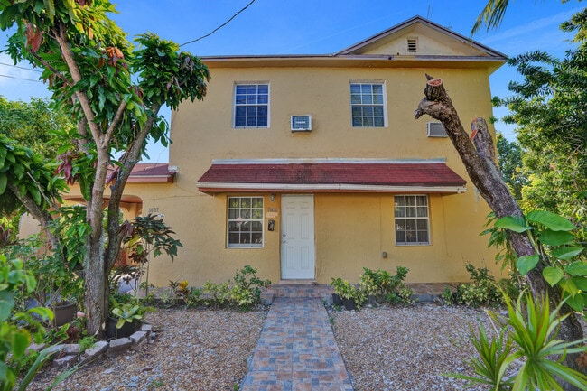
Property Record
3660 Nw 20Th Ave, Miami, FL 33142

NEARBY LISTINGS FOR SALE OR LEASE
Property Detail
3660 Nw 20Th Ave
01-3122-000-0851
22 53 41 .12 AC M/L BEG 234FT E & 443.57FT N OF SW COR OF SE1/4 OF SW1/4 OF SE1/4 E101.78FT S218.57FT W101.78FT N218.57FT TO POB LESS S165.57FT LOT SIZE 5394 SQ FT OR 13143-1396 1286 1 COC 22107-4714 03 2004 4
Duplex
Miami/Dade
AE
Florida
12086C0311L
0.13 AC
2024
Allapattah
2025
South Florida
002404
Miami-Miami Beach-Kendall, FL
3,140 SF
DEMOGRAPHICS near 3660 Nw 20Th Ave
1 Mile
3 Mile
5 Mile
2024 Total Population
32,092
272,178
610,447
2029 Population
31,250
269,921
598,536
Pop Growth 2024-2029
(2.62%)
(0.83%)
(1.95%)
Average Age
41
40
41
2024 Total Households
11,248
105,412
242,419
HH Growth 2024-2029
(2.99%)
(0.68%)
(1.95%)
Median Household Inc
$29,269
$39,534
$49,499
Avg Household Size
2.70
2.40
2.40
2024 Avg HH Vehicles
1.00
1.00
1.00
Median Home Value
$287,267
$330,728
$392,506
Median Year Built
1962
1973
1973
Nearby Places
Map Layers
Map Styles
 Street
 Aerial
- Restaurants
- Banks
- Shops
- Fitness
- Groceries
PUBLIC TRANSPORTATION
COMMUTER RAIL
Earlington Heights (Metrorail Green Line - Miami-Dade Transit (Metrorail/Metromover))
DRIVE
WALK
Distance
Earlington Heights (Metrorail Green Line - Miami-Dade Transit (Metrorail/Metromover))
9 min
10 min
0.5 mi
Allapattah (Metrorail Green Line - Miami-Dade Transit (Metrorail/Metromover))
DRIVE
WALK
Distance
Allapattah (Metrorail Green Line - Miami-Dade Transit (Metrorail/Metromover))
3 min
18 min
1.0 mi
AIRPORT
Miami International
DRIVE
WALK
Distance
Miami International
17 min
7.3 mi
Fort Lauderdale/Hollywood International
DRIVE
WALK
Distance
Fort Lauderdale/Hollywood International
32 min
22.2 mi
Freight Ports
Port of Miami
DRIVE
WALK
Distance
Port of Miami
14 min
6.7 mi
SALE & LEASE HISTORY
LISTING DATE
SALE/LEASE

Jul 02, 2024
For Sale
Nearby Properties
Address
Land Use
TOTAL SIZE
Lot Size
Zoning
Address
Land Use
TOTAL SIZE
Lot Size
Zoning
955,966 SF
38.91 AC
9600
Address
Land Use
TOTAL SIZE
Lot Size
Zoning
928,000 SF
14.30 AC
8000
Address
Land Use
TOTAL SIZE
Lot Size
Zoning
16.13 AC
6100
Address
Land Use
TOTAL SIZE
Lot Size
Zoning
2,789,683 SF
33.23 AC
7300
Address
Land Use
TOTAL SIZE
Lot Size
Zoning
2,403,353 SF
7.37 AC
6100
Address
Land Use
TOTAL SIZE
Lot Size
Zoning
1,938,271 SF
6.62 AC
6402
Address
Land Use
TOTAL SIZE
Lot Size
Zoning
1,075,124 SF
1.61 AC
6405
Address
Land Use
TOTAL SIZE
Lot Size
Zoning
244,533 SF
3.53 AC
6600
Address
Land Use
TOTAL SIZE
Lot Size
Zoning
303,989 SF
1.47 AC
6600
Address
Land Use
TOTAL SIZE
Lot Size
Zoning
256,089 SF
20.35 AC
7600
Address
Land Use
TOTAL SIZE
Lot Size
Zoning
585,775 SF
1.86 AC
6101
Address
Land Use
TOTAL SIZE
Lot Size
Zoning
868,860 SF
2.14 AC
6402
Address
Land Use
TOTAL SIZE
Lot Size
Zoning
615,785 SF
3.81 AC
4604
Address
Land Use
TOTAL SIZE
Lot Size
Zoning
1,262,330 SF
1.39 AC
6402
Address
Land Use
TOTAL SIZE
Lot Size
Zoning
790,139 SF
1.80 AC
6110
Address
Land Use
TOTAL SIZE
Lot Size
Zoning
570,694 SF
1.37 AC
4604
Address
Land Use
TOTAL SIZE
Lot Size
Zoning
990,766 SF
1.16 AC
6420
Address
Land Use
TOTAL SIZE
Lot Size
Zoning
566,165 SF
2.09 AC
6101
Address
Land Use
TOTAL SIZE
Lot Size
Zoning
701,056 SF
1.58 AC
6402
Address
Land Use
TOTAL SIZE
Lot Size
Zoning
996,100 SF
3.58 AC
9600
Address
Land Use
TOTAL SIZE
Lot Size
Zoning
600,250 SF
2.03 AC
6402
Address
Land Use
TOTAL SIZE
Lot Size
Zoning
787,433 SF
2.15 AC
6402
Address
Land Use
TOTAL SIZE
Lot Size
Zoning
627,685 SF
2.06 AC
6100
Address
Land Use
TOTAL SIZE
Lot Size
Zoning
519,775 SF
2.27 AC
6100
Address
Land Use
TOTAL SIZE
Lot Size
Zoning
669,245 SF
0.69 AC
6600
Address
Land Use
TOTAL SIZE
Lot Size
Zoning
602,884 SF
0.32 AC
6412
Address
Land Use
TOTAL SIZE
Lot Size
Zoning
737,810 SF
1.05 AC
6600
Address
Land Use
TOTAL SIZE
Lot Size
Zoning
595,100 SF
0.92 AC
4604
Address
Land Use
TOTAL SIZE
Lot Size
Zoning
428,154 SF
1.39 AC
6101
Address
Land Use
TOTAL SIZE
Lot Size
Zoning
221,570 SF
1.79 AC
6100
The World's #1 Commercial Real Estate Marketplace
Connect with us
© 2025 CoStar Group
The information above has been obtained from sources believed reliable. While we do not doubt its accuracy we have not verified it and make no guarantee, warranty or representation about it. It is your responsibility to independently confirm its accuracy and completeness. Any projections, opinions, assumptions, or estimates used are for example only and do not represent the current or future performance of the property. The value of this transaction to you depends on tax and other factors which should be evaluated by your tax, financial, and legal advisors. You and your advisors should conduct a careful, independent investigation of the property to determine to your satisfaction the suitability of the property for your needs.