Property Record
3660 Tanglewood Trl, Spring Branch, TX 78070
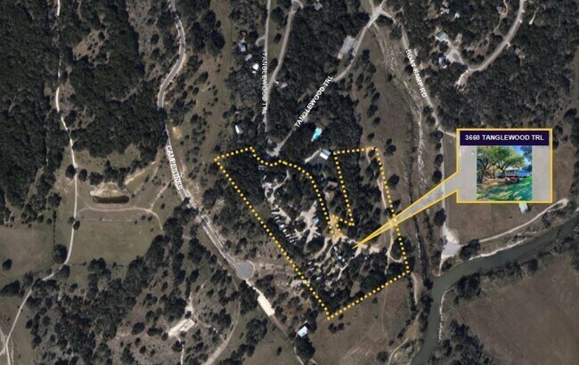

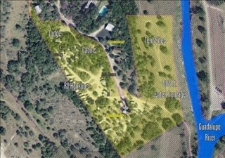

Property Detail
3660 Tanglewood Trl
74-0404-0016-02
A-404 SUR- 48 C MURHARDT, ACRES 14.23
Commercialnec
Comal
AE The base floodplain where base flood elevations are provided. AE Zones are now used on new format FIRMs instead of A1-A30 Zones.
Texas
2024
14.23 AC
2025
Comal County
310609
San Antonio
5,176 SF
San Antonio-New Braunfels, TX
NEARBY LISTINGS FOR SALE OR LEASE
DEMOGRAPHICS near 3660 Tanglewood Trl
1 mile
3 mile
5 mile
2025 Total Population
540
6,278
21,649
2030 Population
636
7,433
25,756
Pop Growth 2025-2030
+ 17.78%
+ 18.40%
+ 18.97%
Average Age
47
46
45
2025 Total Households
226
2,577
8,817
HH Growth 2025-2030
+ 18.14%
+ 18.43%
+ 19.10%
Median Household Inc
$101,042
$92,274
$83,728
Avg Household Size
2.40
2.40
2.40
2025 Avg HH Vehicles
2.00
2.00
2.00
Median Home Value
$387,754
$412,420
$389,025
Median Year Built
2007
2009
2004
Nearby Places
Map Layers
Map Styles
 Street
 Aerial
Transit
 Traffic
 Biking
Places
Listings with unknown addresses are not visible on the map
- Restaurants
- Banks
- Shops
- Fitness
- Groceries
PUBLIC TRANSPORTATION
AIRPORT
San Antonio International
Drive
Walk
Distance
San Antonio International
47 min
36.3 mi
Freight Ports
Calhoun Port
Drive
Walk
Distance
Calhoun Port
208 min
164.9 mi
SALE & LEASE HISTORY
LISTING DATE
SALE/LEASE

May 20, 2019
For Sale
Feb 19, 2020
For Sale
Apr 02, 2018
For Sale
Nearby Properties
Address
Land Use
TOTAL SIZE
Lot Size
Zoning
Address
Land Use
TOTAL SIZE
Lot Size
Zoning
334.47 AC
Address
Land Use
TOTAL SIZE
Lot Size
Zoning
351.98 AC
Address
Land Use
TOTAL SIZE
Lot Size
Zoning
11,213 SF
7.26 AC
Address
Land Use
TOTAL SIZE
Lot Size
Zoning
5,288 SF
133.02 AC
Address
Land Use
TOTAL SIZE
Lot Size
Zoning
13,488 SF
5.87 AC
Address
Land Use
TOTAL SIZE
Lot Size
Zoning
26,658 SF
31.10 AC
Address
Land Use
TOTAL SIZE
Lot Size
Zoning
11,469 SF
206.85 AC
Address
Land Use
TOTAL SIZE
Lot Size
Zoning
117.42 AC
Address
Land Use
TOTAL SIZE
Lot Size
Zoning
4,815 SF
3.79 AC
Address
Land Use
TOTAL SIZE
Lot Size
Zoning
13,078 SF
1.22 AC
Address
Land Use
TOTAL SIZE
Lot Size
Zoning
2,160 SF
13.79 AC
Address
Land Use
TOTAL SIZE
Lot Size
Zoning
6,349 SF
1.01 AC
Address
Land Use
TOTAL SIZE
Lot Size
Zoning
4,255 SF
1.47 AC
Address
Land Use
TOTAL SIZE
Lot Size
Zoning
4,023 SF
1.26 AC
Address
Land Use
TOTAL SIZE
Lot Size
Zoning
4,028 SF
2 AC
Address
Land Use
TOTAL SIZE
Lot Size
Zoning
4,216 SF
1.02 AC
Address
Land Use
TOTAL SIZE
Lot Size
Zoning
5,584 SF
1 AC
Address
Land Use
TOTAL SIZE
Lot Size
Zoning
28.87 AC
Address
Land Use
TOTAL SIZE
Lot Size
Zoning
13.89 AC
Address
Land Use
TOTAL SIZE
Lot Size
Zoning
4,091 SF
1.06 AC
Address
Land Use
TOTAL SIZE
Lot Size
Zoning
3,244 SF
1.02 AC
Address
Land Use
TOTAL SIZE
Lot Size
Zoning
Address
Land Use
TOTAL SIZE
Lot Size
Zoning
4,000 SF
1 AC
Address
Land Use
TOTAL SIZE
Lot Size
Zoning
117.42 AC
Address
Land Use
TOTAL SIZE
Lot Size
Zoning
4,110 SF
2 AC
Address
Land Use
TOTAL SIZE
Lot Size
Zoning
Address
Land Use
TOTAL SIZE
Lot Size
Zoning
4.90 AC
Address
Land Use
TOTAL SIZE
Lot Size
Zoning
3,984 SF
1.20 AC
Address
Land Use
TOTAL SIZE
Lot Size
Zoning
3,816 SF
1.01 AC
The World's #1 Commercial Real Estate Marketplace
Connect with us
© 2026 CoStar Group
The information above has been obtained from sources believed reliable. While we do not doubt its accuracy we have not verified it and make no guarantee, warranty or representation about it. It is your responsibility to independently confirm its accuracy and completeness. Any projections, opinions, assumptions, or estimates used are for example only and do not represent the current or future performance of the property. The value of this transaction to you depends on tax and other factors which should be evaluated by your tax, financial, and legal advisors. You and your advisors should conduct a careful, independent investigation of the property to determine to your satisfaction the suitability of the property for your needs.