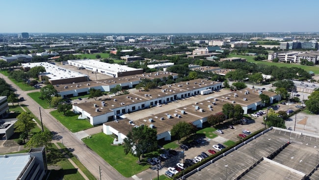
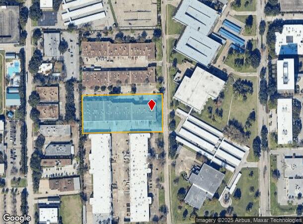
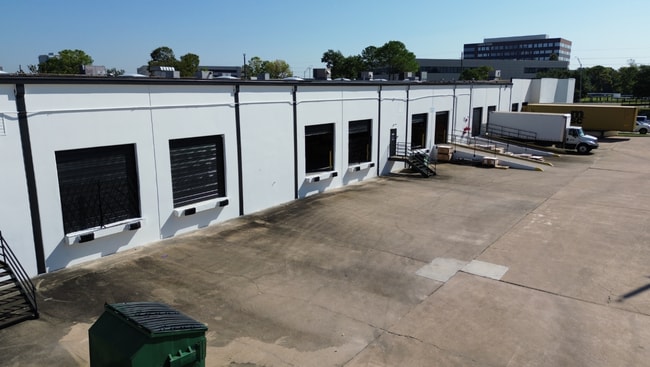
Property Record
3662 Westchase Dr, Houston, TX 77042
NEARBY LISTINGS FOR SALE OR LEASE
Property Detail
3662 Westchase Dr
1113790010016
Westchase Sec 1 Westchase Sec 11 2Nd R/P
Warehouse
RES W12 BLK 23 & RES C4 BLK 1 WESTCHASE SEC 1 WESTCHASE SEC 11 2ND R/P
X
Harris
48157C0175L
Texas
2024
3.27 AC
2025
Southwest Outer Loop
432402
Houston
60,281 SF
Houston-The Woodlands-Sugar Land, TX
DEMOGRAPHICS near 3662 Westchase Dr
1 Mile
3 Mile
5 Mile
2024 Total Population
28,662
218,288
597,266
2029 Population
29,370
223,428
611,754
Pop Growth 2024-2029
+ 2.47%
+ 2.35%
+ 2.43%
Average Age
34
36
36
2024 Total Households
12,818
88,421
234,386
HH Growth 2024-2029
+ 2.32%
+ 2.32%
+ 2.44%
Median Household Inc
$39,126
$45,550
$47,911
Avg Household Size
2.20
2.40
2.50
2024 Avg HH Vehicles
1.00
1.00
2.00
Median Home Value
$148,548
$271,757
$280,922
Median Year Built
1983
1980
1979
Nearby Places
Map Layers
Map Styles
 Street
 Aerial
- Restaurants
- Banks
- Shops
- Fitness
- Groceries
PUBLIC TRANSPORTATION
AIRPORT
William P Hobby
DRIVE
WALK
Distance
William P Hobby
38 min
23.1 mi
George Bush Intcntl/Houston
DRIVE
WALK
Distance
George Bush Intcntl/Houston
38 min
31.8 mi
Freight Ports
Port of Houston
DRIVE
WALK
Distance
Port of Houston
34 min
22.4 mi
SALE & LEASE HISTORY
LISTING DATE
SALE/LEASE

Sep 25, 2016
For Lease
Oct 06, 2020
For Lease
Nearby Properties
Address
Land Use
TOTAL SIZE
Lot Size
Zoning
Address
Land Use
TOTAL SIZE
Lot Size
Zoning
2,198,376 SF
14.18 AC
Address
Land Use
TOTAL SIZE
Lot Size
Zoning
1,020,766 SF
3.08 AC
Address
Land Use
TOTAL SIZE
Lot Size
Zoning
1,082,545 SF
7.22 AC
Address
Land Use
TOTAL SIZE
Lot Size
Zoning
430,096 SF
18.99 AC
Address
Land Use
TOTAL SIZE
Lot Size
Zoning
1,053,492 SF
9.34 AC
Address
Land Use
TOTAL SIZE
Lot Size
Zoning
878,129 SF
11.69 AC
Address
Land Use
TOTAL SIZE
Lot Size
Zoning
794,526 SF
21.25 AC
Address
Land Use
TOTAL SIZE
Lot Size
Zoning
1,172,310 SF
8.17 AC
Address
Land Use
TOTAL SIZE
Lot Size
Zoning
686,506 SF
1.56 AC
Address
Land Use
TOTAL SIZE
Lot Size
Zoning
337,964 SF
9.30 AC
Address
Land Use
TOTAL SIZE
Lot Size
Zoning
967,728 SF
7.40 AC
Address
Land Use
TOTAL SIZE
Lot Size
Zoning
511,262 SF
6.60 AC
Address
Land Use
TOTAL SIZE
Lot Size
Zoning
972,984 SF
30.18 AC
Address
Land Use
TOTAL SIZE
Lot Size
Zoning
361,954 SF
14.43 AC
Address
Land Use
TOTAL SIZE
Lot Size
Zoning
291,829 SF
4.22 AC
Address
Land Use
TOTAL SIZE
Lot Size
Zoning
526,410 SF
20.43 AC
Address
Land Use
TOTAL SIZE
Lot Size
Zoning
845,371 SF
32.37 AC
Address
Land Use
TOTAL SIZE
Lot Size
Zoning
367,309 SF
14.72 AC
Address
Land Use
TOTAL SIZE
Lot Size
Zoning
261,886 SF
6.12 AC
Address
Land Use
TOTAL SIZE
Lot Size
Zoning
497,267 SF
24.69 AC
Address
Land Use
TOTAL SIZE
Lot Size
Zoning
380,423 SF
15.14 AC
Address
Land Use
TOTAL SIZE
Lot Size
Zoning
771,720 SF
19.28 AC
Address
Land Use
TOTAL SIZE
Lot Size
Zoning
344,088 SF
13.77 AC
Address
Land Use
TOTAL SIZE
Lot Size
Zoning
383,540 SF
4.43 AC
Address
Land Use
TOTAL SIZE
Lot Size
Zoning
598,127 SF
4.14 AC
Address
Land Use
TOTAL SIZE
Lot Size
Zoning
340,136 SF
13.34 AC
Address
Land Use
TOTAL SIZE
Lot Size
Zoning
362,473 SF
15.65 AC
Address
Land Use
TOTAL SIZE
Lot Size
Zoning
539,308 SF
21 AC
Address
Land Use
TOTAL SIZE
Lot Size
Zoning
473,207 SF
15.50 AC
Address
Land Use
TOTAL SIZE
Lot Size
Zoning
997,813 SF
5.25 AC
The World's #1 Commercial Real Estate Marketplace
Connect with us
© 2025 CoStar Group
The information above has been obtained from sources believed reliable. While we do not doubt its accuracy we have not verified it and make no guarantee, warranty or representation about it. It is your responsibility to independently confirm its accuracy and completeness. Any projections, opinions, assumptions, or estimates used are for example only and do not represent the current or future performance of the property. The value of this transaction to you depends on tax and other factors which should be evaluated by your tax, financial, and legal advisors. You and your advisors should conduct a careful, independent investigation of the property to determine to your satisfaction the suitability of the property for your needs.