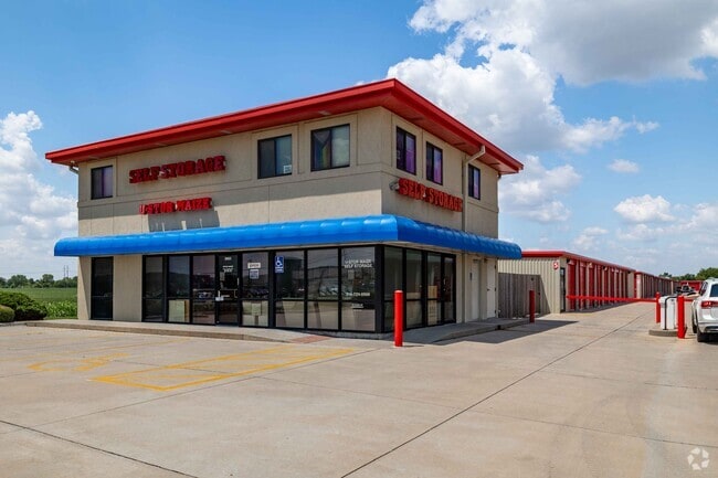
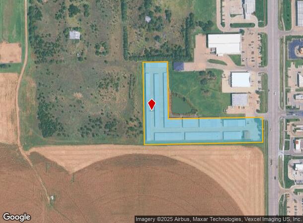
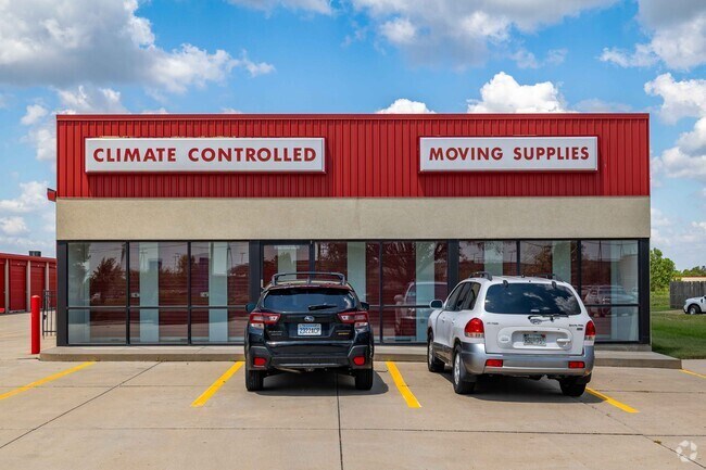
Property Record
3663 N Maize Rd, Wichita, KS 67205
NEARBY LISTINGS FOR SALE OR LEASE
Property Detail
3663 N Maize Rd
Wichita, KS
Wadley Ranch Add
089-31-0-11-02-006.02
LOT 5 & W 153.16 FT & S 157 FT LOT 6 BLOCK 1 WADLEY RANCH ADDITION
Publicstorage
Sedgwick
X
Kansas
20173C0327G
5,6
2024
3.92 AC
2025
Outlying Sedgwick County
010302
Wichita
78,780 SF
DEMOGRAPHICS near 3663 N Maize Rd
1 Mile
3 Mile
5 Mile
2024 Total Population
5,516
40,166
81,241
2029 Population
5,812
40,773
82,342
Pop Growth 2024-2029
+ 5.37%
+ 1.51%
+ 1.36%
Average Age
37
40
40
2024 Total Households
2,020
14,655
31,833
HH Growth 2024-2029
+ 5.54%
+ 1.53%
+ 1.40%
Median Household Inc
$116,147
$104,591
$87,819
Avg Household Size
2.70
2.70
2.50
2024 Avg HH Vehicles
2.00
2.00
2.00
Median Home Value
$364,245
$279,601
$258,293
Median Year Built
2010
1997
1990
Nearby Places
Map Layers
Map Styles
 Street
 Aerial
- Restaurants
- Banks
- Shops
- Fitness
- Groceries
PUBLIC TRANSPORTATION
AIRPORT
Wichita Dwight D Eisenhower Ntl
DRIVE
WALK
Distance
Wichita Dwight D Eisenhower Ntl
18 min
9.4 mi
Freight Ports
Tulsa Port Of Catoosa
DRIVE
WALK
Distance
Tulsa Port Of Catoosa
219 min
202.4 mi
Nearby Properties
Address
Land Use
TOTAL SIZE
Lot Size
Zoning
Address
Land Use
TOTAL SIZE
Lot Size
Zoning
662,237 SF
179.74 AC
SF-5
Address
Land Use
TOTAL SIZE
Lot Size
Zoning
558,228 SF
126.95 AC
SF-5
Address
Land Use
TOTAL SIZE
Lot Size
Zoning
160,112 SF
58.49 AC
AA
Address
Land Use
TOTAL SIZE
Lot Size
Zoning
108,480 SF
14.90 AC
GO
Address
Land Use
TOTAL SIZE
Lot Size
Zoning
175,639 SF
22.91 AC
SF-5
Address
Land Use
TOTAL SIZE
Lot Size
Zoning
82,854 SF
49.09 AC
LC,SF-5
Address
Land Use
TOTAL SIZE
Lot Size
Zoning
113,253 SF
21.17 AC
SF-5
Address
Land Use
TOTAL SIZE
Lot Size
Zoning
104,252 SF
7.24 AC
SF-5
Address
Land Use
TOTAL SIZE
Lot Size
Zoning
99,933 SF
9.98 AC
SF-5
Address
Land Use
TOTAL SIZE
Lot Size
Zoning
74,378 SF
14.63 AC
GO
Address
Land Use
TOTAL SIZE
Lot Size
Zoning
89,126 SF
34.29 AC
R6
Address
Land Use
TOTAL SIZE
Lot Size
Zoning
38,927 SF
5 AC
LC
Address
Land Use
TOTAL SIZE
Lot Size
Zoning
77,159 SF
5.97 AC
SF-5
Address
Land Use
TOTAL SIZE
Lot Size
Zoning
84,317 SF
7.18 AC
SF-5
Address
Land Use
TOTAL SIZE
Lot Size
Zoning
29,952 SF
3.98 AC
GO
Address
Land Use
TOTAL SIZE
Lot Size
Zoning
173,604 SF
21.29 AC
LC
Address
Land Use
TOTAL SIZE
Lot Size
Zoning
68,496 SF
18.11 AC
LC
Address
Land Use
TOTAL SIZE
Lot Size
Zoning
47,158 SF
211.18 AC
SF-20,LC
Address
Land Use
TOTAL SIZE
Lot Size
Zoning
34,963 SF
6.13 AC
Address
Land Use
TOTAL SIZE
Lot Size
Zoning
33,953 SF
10.05 AC
SF-5
Address
Land Use
TOTAL SIZE
Lot Size
Zoning
37,055 SF
19.24 AC
SF-20
Address
Land Use
TOTAL SIZE
Lot Size
Zoning
24,134 SF
8.78 AC
B1
Address
Land Use
TOTAL SIZE
Lot Size
Zoning
54,158 SF
6.74 AC
RR
Address
Land Use
TOTAL SIZE
Lot Size
Zoning
36,818 SF
14.91 AC
SF-5
Address
Land Use
TOTAL SIZE
Lot Size
Zoning
94,866 SF
7.40 AC
LC
Address
Land Use
TOTAL SIZE
Lot Size
Zoning
39,299 SF
4.82 AC
SF-5
Address
Land Use
TOTAL SIZE
Lot Size
Zoning
18,125 SF
5.91 AC
SF-5
Address
Land Use
TOTAL SIZE
Lot Size
Zoning
90,279 SF
11.70 AC
LC
Address
Land Use
TOTAL SIZE
Lot Size
Zoning
70,160 SF
13.48 AC
AA
The World's #1 Commercial Real Estate Marketplace
Connect with us
© 2026 CoStar Group
The information above has been obtained from sources believed reliable. While we do not doubt its accuracy we have not verified it and make no guarantee, warranty or representation about it. It is your responsibility to independently confirm its accuracy and completeness. Any projections, opinions, assumptions, or estimates used are for example only and do not represent the current or future performance of the property. The value of this transaction to you depends on tax and other factors which should be evaluated by your tax, financial, and legal advisors. You and your advisors should conduct a careful, independent investigation of the property to determine to your satisfaction the suitability of the property for your needs.