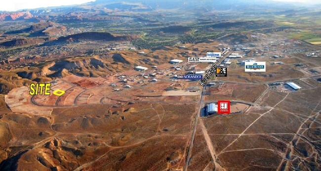
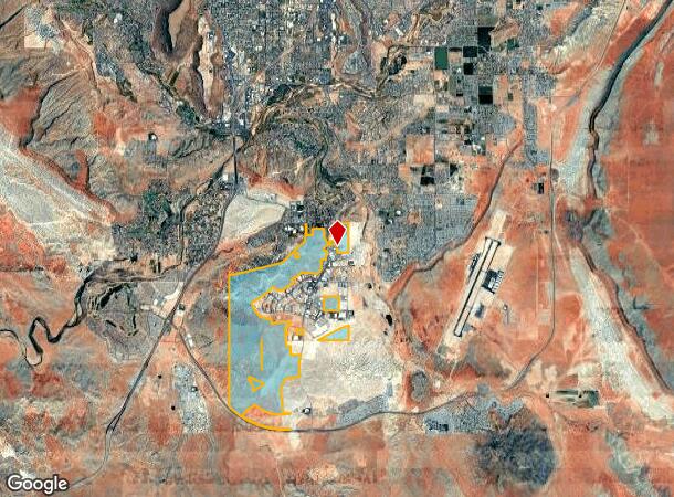
Property Record
3665 S River Rd, Saint George, UT 84790
NEARBY LISTINGS FOR SALE OR LEASE
Property Detail
3665 S River Rd
St. George, UT
Fort Pierce Indust Park
0741440
S: 19 T: 43S R: 15W S: 17 T: 43S R: 15W S: 18 T: 43S R: 15W S: 20 T: 43S R: 15W SEC 17 T43S R15W. ALSO: SEC 20 T43S R15W. ALSO: LOTS 1,3 & 4; E1/2 W1/2; E1/2 SEC 18 T43S R15W. ALSO: LOTS 1,3 & 4; E1/2 NW1/4; NE1/4 SW1/4; E1/2, SE1/4 SW1/4 SEC 19 T43S
Taxexempt
Washington
X
Utah
49053C1037G
3
0
1,063.96 AC
2025
Cedar City & St George
271704
Other Market Areas
DEMOGRAPHICS near 3665 S River Rd
1 Mile
3 Mile
5 Mile
2024 Total Population
558
29,919
65,307
2029 Population
716
37,279
81,519
Pop Growth 2024-2029
+ 28.32%
+ 24.60%
+ 24.82%
Average Age
32
42
40
2024 Total Households
170
10,137
21,623
HH Growth 2024-2029
+ 29.41%
+ 24.92%
+ 25.23%
Median Household Inc
$65,454
$76,760
$74,581
Avg Household Size
3.30
2.90
2.90
2024 Avg HH Vehicles
2.00
2.00
2.00
Median Home Value
$442,500
$456,391
$464,800
Median Year Built
2010
2005
2003
Nearby Places
Map Layers
Map Styles
 Street
 Aerial
- Restaurants
- Banks
- Shops
- Fitness
- Groceries
PUBLIC TRANSPORTATION
AIRPORT
St George Regional
DRIVE
WALK
Distance
St George Regional
15 min
7.0 mi
Freight Ports
Port of Long Beach
DRIVE
WALK
Distance
Port of Long Beach
442 min
401.3 mi
Nearby Properties
Address
Land Use
TOTAL SIZE
Lot Size
Zoning
Address
Land Use
TOTAL SIZE
Lot Size
Zoning
823,767 SF
88.46 AC
Address
Land Use
TOTAL SIZE
Lot Size
Zoning
163,605 SF
13.51 AC
C3
Address
Land Use
TOTAL SIZE
Lot Size
Zoning
322,075 SF
26.62 AC
Address
Land Use
TOTAL SIZE
Lot Size
Zoning
259,012 SF
22 AC
M-1
Address
Land Use
TOTAL SIZE
Lot Size
Zoning
173,917 SF
50 AC
M-1
Address
Land Use
TOTAL SIZE
Lot Size
Zoning
206,801 SF
12.60 AC
PD
Address
Land Use
TOTAL SIZE
Lot Size
Zoning
196,334 SF
22.87 AC
PDCOM
Address
Land Use
TOTAL SIZE
Lot Size
Zoning
152,090 SF
25 AC
M-1
Address
Land Use
TOTAL SIZE
Lot Size
Zoning
51,302 SF
56.23 AC
OST20
Address
Land Use
TOTAL SIZE
Lot Size
Zoning
87,750 SF
15.92 AC
Address
Land Use
TOTAL SIZE
Lot Size
Zoning
97,202 SF
2.92 AC
C3
Address
Land Use
TOTAL SIZE
Lot Size
Zoning
77,771 SF
6.02 AC
A1
Address
Land Use
TOTAL SIZE
Lot Size
Zoning
91,798 SF
5 AC
M-1
Address
Land Use
TOTAL SIZE
Lot Size
Zoning
169,923 SF
9.41 AC
Address
Land Use
TOTAL SIZE
Lot Size
Zoning
405 SF
407.69 AC
R110
Address
Land Use
TOTAL SIZE
Lot Size
Zoning
3,432 SF
57.26 AC
A20
Address
Land Use
TOTAL SIZE
Lot Size
Zoning
209,687 SF
7.54 AC
M-1
Address
Land Use
TOTAL SIZE
Lot Size
Zoning
56,572 SF
12 AC
Address
Land Use
TOTAL SIZE
Lot Size
Zoning
16,800 SF
250 AC
OS
Address
Land Use
TOTAL SIZE
Lot Size
Zoning
2,268 SF
49.03 AC
A20
Address
Land Use
TOTAL SIZE
Lot Size
Zoning
122,761 SF
10.22 AC
M-1
Address
Land Use
TOTAL SIZE
Lot Size
Zoning
76,560 SF
2.32 AC
Address
Land Use
TOTAL SIZE
Lot Size
Zoning
63,519 SF
1.86 AC
Address
Land Use
TOTAL SIZE
Lot Size
Zoning
49,299 SF
1.85 AC
C-3
Address
Land Use
TOTAL SIZE
Lot Size
Zoning
97,357 SF
5.67 AC
M-1
Address
Land Use
TOTAL SIZE
Lot Size
Zoning
100,110 SF
8.48 AC
M-1
Address
Land Use
TOTAL SIZE
Lot Size
Zoning
32,232 SF
3.05 AC
C3
Address
Land Use
TOTAL SIZE
Lot Size
Zoning
74,395 SF
2.20 AC
C3
The World's #1 Commercial Real Estate Marketplace
Connect with us
© 2026 CoStar Group
The information above has been obtained from sources believed reliable. While we do not doubt its accuracy we have not verified it and make no guarantee, warranty or representation about it. It is your responsibility to independently confirm its accuracy and completeness. Any projections, opinions, assumptions, or estimates used are for example only and do not represent the current or future performance of the property. The value of this transaction to you depends on tax and other factors which should be evaluated by your tax, financial, and legal advisors. You and your advisors should conduct a careful, independent investigation of the property to determine to your satisfaction the suitability of the property for your needs.