Property Record
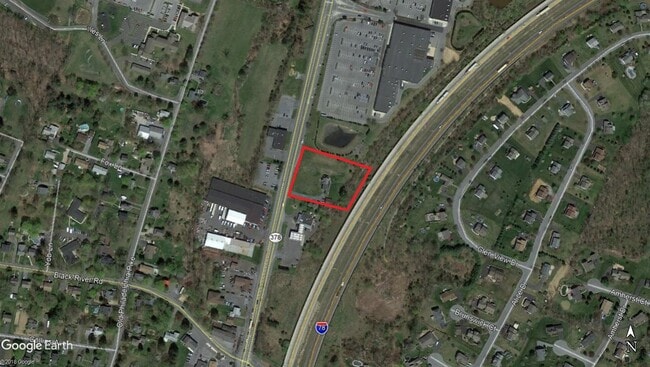
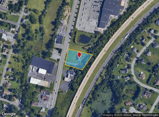
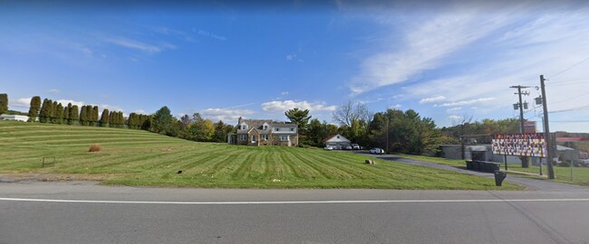
3667 Route 378, Bethlehem, PA 18015
NEARBY LISTINGS FOR SALE OR LEASE
Property Detail
3667 Route 378
Allentown-Bethlehem-Easton, PA-NJ
Roeder Terrace Iv Subdivision
Q6SW2 4 1 0719
Northampton
Sfr
Pennsylvania
X
1.07 AC
42095C0309E
Lehigh Valley
2,596 SF
Philadelphia
DEMOGRAPHICS near 3667 Route 378
1 Mile
3 Mile
5 Mile
2024 Total Population
3,619
65,966
191,947
2029 Population
3,645
66,408
193,452
Pop Growth 2024-2029
+ 0.72%
+ 0.67%
+ 0.78%
Average Age
43
38
39
2024 Total Households
1,320
24,502
73,050
HH Growth 2024-2029
+ 0.91%
+ 0.80%
+ 0.89%
Median Household Inc
$104,167
$60,269
$59,280
Avg Household Size
2.70
2.40
2.40
2024 Avg HH Vehicles
2.00
2.00
2.00
Median Home Value
$383,834
$226,774
$208,604
Median Year Built
1970
1951
1957
Nearby Places
Map Layers
Map Styles
 Street
 Aerial
- Restaurants
- Banks
- Shops
- Fitness
- Groceries
PUBLIC TRANSPORTATION
AIRPORT
Lehigh Valley International
DRIVE
WALK
Distance
Lehigh Valley International
21 min
13.0 mi
Freight Ports
Port of Philadelphia
DRIVE
WALK
Distance
Port of Philadelphia
82 min
51.7 mi
SALE & LEASE HISTORY
LISTING DATE
SALE/LEASE

Jun 13, 2023
For Sale
Nearby Properties
Address
Land Use
TOTAL SIZE
Lot Size
Zoning
Address
Land Use
TOTAL SIZE
Lot Size
Zoning
541,843 SF
35.82 AC
INST
Address
Land Use
TOTAL SIZE
Lot Size
Zoning
425,507 SF
52.58 AC
HI
Address
Land Use
TOTAL SIZE
Lot Size
Zoning
53,602 SF
55.38 AC
E
Address
Land Use
TOTAL SIZE
Lot Size
Zoning
184,739 SF
6.75 AC
I
Address
Land Use
TOTAL SIZE
Lot Size
Zoning
125,483 SF
45.29 AC
E
Address
Land Use
TOTAL SIZE
Lot Size
Zoning
101,901 SF
29.01 AC
E
Address
Land Use
TOTAL SIZE
Lot Size
Zoning
565,540 SF
65.99 AC
I
Address
Land Use
TOTAL SIZE
Lot Size
Zoning
164,178 SF
14.88 AC
E
Address
Land Use
TOTAL SIZE
Lot Size
Zoning
335,939 SF
54 AC
E
Address
Land Use
TOTAL SIZE
Lot Size
Zoning
12,838 SF
36.50 AC
IP
Address
Land Use
TOTAL SIZE
Lot Size
Zoning
139,782 SF
27.47 AC
R4
Address
Land Use
TOTAL SIZE
Lot Size
Zoning
11,856 SF
454.48 AC
CM
Address
Land Use
TOTAL SIZE
Lot Size
Zoning
87,517 SF
7.09 AC
E
Address
Land Use
TOTAL SIZE
Lot Size
Zoning
332,641 SF
2.27 AC
HI
Address
Land Use
TOTAL SIZE
Lot Size
Zoning
106,829 SF
14.15 AC
R4
Address
Land Use
TOTAL SIZE
Lot Size
Zoning
80,277 SF
3.23 AC
MHDR
Address
Land Use
TOTAL SIZE
Lot Size
Zoning
98,026 SF
5.99 AC
E
Address
Land Use
TOTAL SIZE
Lot Size
Zoning
10,572 SF
54.17 AC
IP
Address
Land Use
TOTAL SIZE
Lot Size
Zoning
77,347 SF
6.82 AC
E
Address
Land Use
TOTAL SIZE
Lot Size
Zoning
230,780 SF
14.48 AC
I
Address
Land Use
TOTAL SIZE
Lot Size
Zoning
347,514 SF
10.27 AC
RM
Address
Land Use
TOTAL SIZE
Lot Size
Zoning
69,059 SF
7.01 AC
E
Address
Land Use
TOTAL SIZE
Lot Size
Zoning
31,442 SF
9.87 AC
IP
Address
Land Use
TOTAL SIZE
Lot Size
Zoning
39,016 SF
17.40 AC
RG
Address
Land Use
TOTAL SIZE
Lot Size
Zoning
24,354 SF
11.16 AC
HI
Address
Land Use
TOTAL SIZE
Lot Size
Zoning
103,214 SF
2.55 AC
RT
Address
Land Use
TOTAL SIZE
Lot Size
Zoning
21,462 SF
255.01 AC
IP
Address
Land Use
TOTAL SIZE
Lot Size
Zoning
75,251 SF
4.76 AC
LI
Address
Land Use
TOTAL SIZE
Lot Size
Zoning
5,578 SF
11.80 AC
R-2
Address
Land Use
TOTAL SIZE
Lot Size
Zoning
85,304 SF
0.38 AC
INST
The World's #1 Commercial Real Estate Marketplace
Connect with us
© 2025 CoStar Group
The information above has been obtained from sources believed reliable. While we do not doubt its accuracy we have not verified it and make no guarantee, warranty or representation about it. It is your responsibility to independently confirm its accuracy and completeness. Any projections, opinions, assumptions, or estimates used are for example only and do not represent the current or future performance of the property. The value of this transaction to you depends on tax and other factors which should be evaluated by your tax, financial, and legal advisors. You and your advisors should conduct a careful, independent investigation of the property to determine to your satisfaction the suitability of the property for your needs.