Property Record
367 Highway 36, Hazlet, NJ 07730
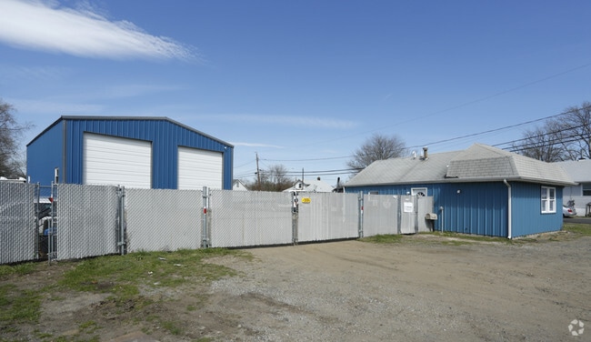

Property Detail
367 Highway 36
18-00020-0000-00012
TWO BUILDINGS
Servicestation
MONMOUTH
BH
New Jersey
AE The base floodplain where base flood elevations are provided. AE Zones are now used on new format FIRMs instead of A1-A30 Zones.
12
2024
0.30 AC
2025
Eastern Monmouth
802300
Northern New Jersey
680 SF
Lakewood-New Brunswick, NJ
NEARBY LISTINGS FOR SALE OR LEASE
-
-
View all Hazlet listings for sale on LoopNet.com
DEMOGRAPHICS near 367 Highway 36
1 mile
3 mile
5 mile
2025 Total Population
9,772
62,265
113,167
2030 Population
9,736
62,090
112,659
Pop Growth 2025-2030
(0.37%)
(0.28%)
(0.45%)
Average Age
42
42
42
2025 Total Households
3,706
22,866
41,551
HH Growth 2025-2030
(0.67%)
(0.49%)
(0.62%)
Median Household Inc
$94,151
$110,191
$118,544
Avg Household Size
2.50
2.60
2.60
2025 Avg HH Vehicles
2.00
2.00
2.00
Median Home Value
$393,116
$476,537
$500,975
Median Year Built
1961
1966
1967
Nearby Places
Map Layers
Map Styles
 Street
 Aerial
Layers
 Traffic
 Biking
Places
Listings with unknown addresses are not visible on the map
- Restaurants
- Banks
- Shops
- Fitness
- Groceries
PUBLIC TRANSPORTATION
COMMUTER RAIL
Hazlet (North Jersey Coast Line - NJ Transit Commuter Rail (NJ Transit))
Drive
Walk
Distance
Hazlet (North Jersey Coast Line - NJ Transit Commuter Rail (NJ Transit))
6 min
4.0 mi
Middletown Nj (North Jersey Coast Line - NJ TRANSIT RAIL)
Drive
Walk
Distance
Middletown Nj (North Jersey Coast Line - NJ TRANSIT RAIL)
12 min
6.1 mi
AIRPORT
Newark Liberty International
Drive
Walk
Distance
Newark Liberty International
42 min
30.8 mi
LaGuardia
Drive
Walk
Distance
LaGuardia
71 min
48.2 mi
Freight Ports
New York Container Terminal
Drive
Walk
Distance
New York Container Terminal
35 min
25.9 mi
SALE & LEASE HISTORY
LISTING DATE
SALE/LEASE

Sep 24, 2016
For Sale
May 23, 2017
For Sale
Nearby Properties
Address
Land Use
TOTAL SIZE
Lot Size
Zoning
Address
Land Use
TOTAL SIZE
Lot Size
Zoning
838,137 SF
253 AC
R45
Address
Land Use
TOTAL SIZE
Lot Size
Zoning
2.91 AC
Address
Land Use
TOTAL SIZE
Lot Size
Zoning
6,500 SF
48.71 AC
CI
Address
Land Use
TOTAL SIZE
Lot Size
Zoning
37.83 AC
PUD
Address
Land Use
TOTAL SIZE
Lot Size
Zoning
10.44 AC
TMHO
Address
Land Use
TOTAL SIZE
Lot Size
Zoning
147,236 SF
20.01 AC
MU15
Address
Land Use
TOTAL SIZE
Lot Size
Zoning
29.59 AC
CI
Address
Land Use
TOTAL SIZE
Lot Size
Zoning
118,375 SF
18.20 AC
MU15
Address
Land Use
TOTAL SIZE
Lot Size
Zoning
151,463 SF
20.58 AC
M-2
Address
Land Use
TOTAL SIZE
Lot Size
Zoning
39,965 SF
17.14 AC
BH
Address
Land Use
TOTAL SIZE
Lot Size
Zoning
186,567 SF
2.31 AC
RC
Address
Land Use
TOTAL SIZE
Lot Size
Zoning
83,449 SF
0.57 AC
SF05
Address
Land Use
TOTAL SIZE
Lot Size
Zoning
3,641 SF
22.58 AC
C1
Address
Land Use
TOTAL SIZE
Lot Size
Zoning
196,948 SF
19.80 AC
BH
Address
Land Use
TOTAL SIZE
Lot Size
Zoning
42,314 SF
52 AC
IA
Address
Land Use
TOTAL SIZE
Lot Size
Zoning
127,410 SF
6.02 AC
MF15
Address
Land Use
TOTAL SIZE
Lot Size
Zoning
420 SF
87.76 AC
OL2
Address
Land Use
TOTAL SIZE
Lot Size
Zoning
8.62 AC
RC
Address
Land Use
TOTAL SIZE
Lot Size
Zoning
6 AC
RC
Address
Land Use
TOTAL SIZE
Lot Size
Zoning
83,416 SF
44.01 AC
R22
Address
Land Use
TOTAL SIZE
Lot Size
Zoning
5 AC
PUD
Address
Land Use
TOTAL SIZE
Lot Size
Zoning
141,313 SF
23.19 AC
SF20
Address
Land Use
TOTAL SIZE
Lot Size
Zoning
69,541 SF
2.39 AC
B-2
Address
Land Use
TOTAL SIZE
Lot Size
Zoning
9,904 SF
135.45 AC
M-2
Address
Land Use
TOTAL SIZE
Lot Size
Zoning
67,832 SF
10.46 AC
RGA
Address
Land Use
TOTAL SIZE
Lot Size
Zoning
132,885 SF
3.15 AC
SF05
Address
Land Use
TOTAL SIZE
Lot Size
Zoning
28 AC
RO3
Address
Land Use
TOTAL SIZE
Lot Size
Zoning
4,078 SF
15.14 AC
SC2
Address
Land Use
TOTAL SIZE
Lot Size
Zoning
124,651 SF
25.02 AC
CD
Address
Land Use
TOTAL SIZE
Lot Size
Zoning
142,360 SF
16.50 AC
BH
The World's #1 Commercial Real Estate Marketplace
Connect with us
© 2026 CoStar Group
The information above has been obtained from sources believed reliable. While we do not doubt its accuracy we have not verified it and make no guarantee, warranty or representation about it. It is your responsibility to independently confirm its accuracy and completeness. Any projections, opinions, assumptions, or estimates used are for example only and do not represent the current or future performance of the property. The value of this transaction to you depends on tax and other factors which should be evaluated by your tax, financial, and legal advisors. You and your advisors should conduct a careful, independent investigation of the property to determine to your satisfaction the suitability of the property for your needs.