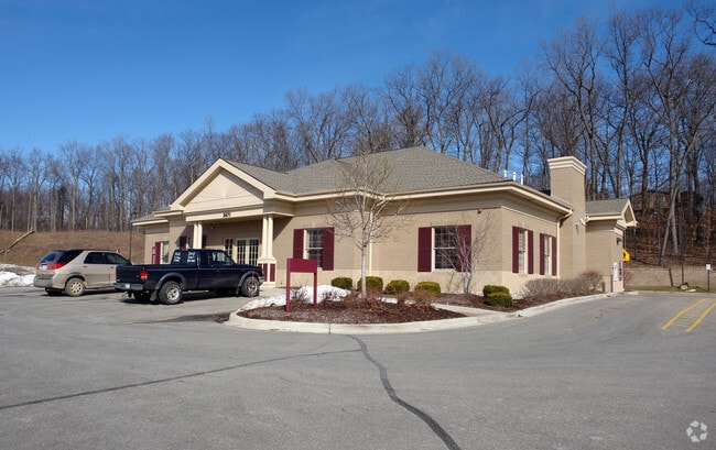
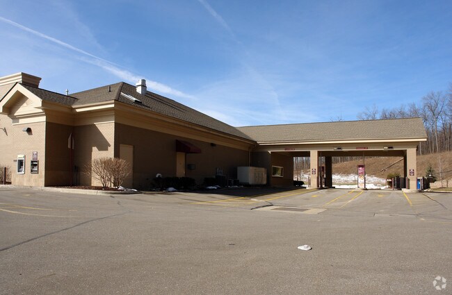
Property Record
3671 Highland Rd, White Lake, MI 48383

NEARBY LISTINGS FOR SALE OR LEASE
-
-
View all White Lake listings for sale on LoopNet.com
Property Detail
3671 Highland Rd
12-19-101-037
T3N, R8E, SEC 29 PART OF NW FRAC 1/4 BEG AT PT DIST S 89-47-08 E 300.52 FT FROM NW SEC COR, TH 89-47-08 E 688.82 FT, TH S 00-33-21 W 282.10 FT, TH S 86-44-28 W 141.76 FT, TH ALG CURVE TO RIGHT, RAD 3727.72 FT, CHORD BEARS S 89-45-56 W 393.35 FT, DIST
Financialbuilding
Oakland
X
Michigan
26125C0318F
4.62 AC
2024
St Clair & Lapeer Counties
2024
Detroit
130200
Detroit-Warren-Dearborn, MI
4,923 SF
DEMOGRAPHICS near 3671 Highland Rd
1 Mile
3 Mile
5 Mile
2024 Total Population
1,927
19,450
53,393
2029 Population
1,918
19,282
53,074
Pop Growth 2024-2029
(0.47%)
(0.86%)
(0.60%)
Average Age
43
42
43
2024 Total Households
768
7,491
20,479
HH Growth 2024-2029
(0.39%)
(0.84%)
(0.63%)
Median Household Inc
$92,115
$90,815
$97,208
Avg Household Size
2.50
2.60
2.60
2024 Avg HH Vehicles
2.00
2.00
2.00
Median Home Value
$325,146
$297,549
$333,295
Median Year Built
1974
1979
1984
Nearby Places
Map Layers
Map Styles
 Street
 Aerial
- Restaurants
- Banks
- Shops
- Fitness
- Groceries
PUBLIC TRANSPORTATION
AIRPORT
Bishop International
DRIVE
WALK
Distance
Bishop International
52 min
35.6 mi
Freight Ports
Port of Toledo
DRIVE
WALK
Distance
Port of Toledo
107 min
84.1 mi
Nearby Properties
Address
Land Use
TOTAL SIZE
Lot Size
Zoning
Address
Land Use
TOTAL SIZE
Lot Size
Zoning
9,452 SF
Address
Land Use
TOTAL SIZE
Lot Size
Zoning
4,260 SF
101.34 AC
MM
Address
Land Use
TOTAL SIZE
Lot Size
Zoning
6,498 SF
77.52 AC
MM
Address
Land Use
TOTAL SIZE
Lot Size
Zoning
207,282 SF
55.01 AC
BI
Address
Land Use
TOTAL SIZE
Lot Size
Zoning
42,467 SF
13.70 AC
Address
Land Use
TOTAL SIZE
Lot Size
Zoning
46,500 SF
5.86 AC
BI
Address
Land Use
TOTAL SIZE
Lot Size
Zoning
88,540 SF
9.07 AC
PB
Address
Land Use
TOTAL SIZE
Lot Size
Zoning
34,854 SF
5.28 AC
AI
Address
Land Use
TOTAL SIZE
Lot Size
Zoning
45,644 SF
7.74 AC
BI
Address
Land Use
TOTAL SIZE
Lot Size
Zoning
38,846 SF
6.78 AC
BI
Address
Land Use
TOTAL SIZE
Lot Size
Zoning
55,183 SF
Address
Land Use
TOTAL SIZE
Lot Size
Zoning
47,204 SF
10.77 AC
II
Address
Land Use
TOTAL SIZE
Lot Size
Zoning
24,370 SF
4.86 AC
BI
Address
Land Use
TOTAL SIZE
Lot Size
Zoning
23,300 SF
3.99 AC
BI
Address
Land Use
TOTAL SIZE
Lot Size
Zoning
36,928 SF
5.16 AC
II
Address
Land Use
TOTAL SIZE
Lot Size
Zoning
68,340 SF
5.48 AC
II
Address
Land Use
TOTAL SIZE
Lot Size
Zoning
58,677 SF
16.70 AC
II
Address
Land Use
TOTAL SIZE
Lot Size
Zoning
25,432 SF
4.53 AC
AI
Address
Land Use
TOTAL SIZE
Lot Size
Zoning
15.74 AC
MM
Address
Land Use
TOTAL SIZE
Lot Size
Zoning
12,463 SF
4.73 AC
Address
Land Use
TOTAL SIZE
Lot Size
Zoning
38,449 SF
2.60 AC
IV
Address
Land Use
TOTAL SIZE
Lot Size
Zoning
11,400 SF
1.44 AC
Address
Land Use
TOTAL SIZE
Lot Size
Zoning
24,027 SF
2.10 AC
BV
Address
Land Use
TOTAL SIZE
Lot Size
Zoning
13,000 SF
19.01 AC
II
Address
Land Use
TOTAL SIZE
Lot Size
Zoning
12,601 SF
2.54 AC
BI
Address
Land Use
TOTAL SIZE
Lot Size
Zoning
40,700 SF
8.19 AC
II
Address
Land Use
TOTAL SIZE
Lot Size
Zoning
22,880 SF
2.67 AC
II
Address
Land Use
TOTAL SIZE
Lot Size
Zoning
24,925 SF
5.30 AC
II
Address
Land Use
TOTAL SIZE
Lot Size
Zoning
3,865 SF
2.57 AC
BI
Address
Land Use
TOTAL SIZE
Lot Size
Zoning
29,143 SF
9.62 AC
BI
The World's #1 Commercial Real Estate Marketplace
Connect with us
© 2025 CoStar Group
The information above has been obtained from sources believed reliable. While we do not doubt its accuracy we have not verified it and make no guarantee, warranty or representation about it. It is your responsibility to independently confirm its accuracy and completeness. Any projections, opinions, assumptions, or estimates used are for example only and do not represent the current or future performance of the property. The value of this transaction to you depends on tax and other factors which should be evaluated by your tax, financial, and legal advisors. You and your advisors should conduct a careful, independent investigation of the property to determine to your satisfaction the suitability of the property for your needs.