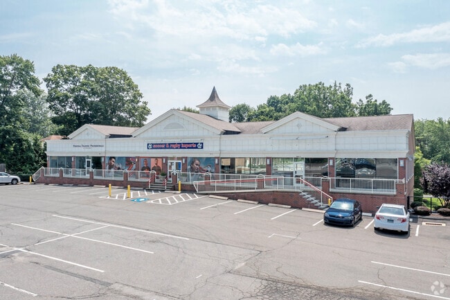
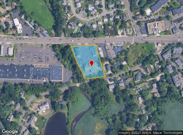
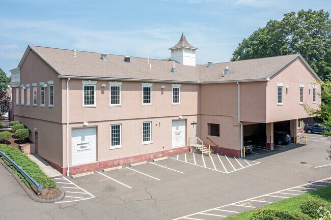
Property Record
3671 Post Rd, Southport, CT 06890
NEARBY LISTINGS FOR SALE OR LEASE
Property Detail
3671 Post Rd
FAIR-000285-000000-000003
Fairfield
Commercialnec
Connecticut
AE
1.60 AC
09001C0418G
Fairfield
2025
Westchester/So Connecticut
2025
Bridgeport-Stamford-Norwalk, CT
060600
DEMOGRAPHICS near 3671 Post Rd
1 Mile
3 Mile
5 Mile
2024 Total Population
5,798
38,762
99,871
2029 Population
5,901
39,141
100,564
Pop Growth 2024-2029
+ 1.78%
+ 0.98%
+ 0.69%
Average Age
43
40
40
2024 Total Households
2,233
12,725
36,080
HH Growth 2024-2029
+ 1.84%
+ 1.15%
+ 0.70%
Median Household Inc
$197,242
$197,165
$141,329
Avg Household Size
2.50
2.70
2.60
2024 Avg HH Vehicles
2.00
2.00
2.00
Median Home Value
$941,546
$911,107
$802,138
Median Year Built
1977
1964
1962
Nearby Places
Map Layers
Map Styles
 Street
 Aerial
- Restaurants
- Banks
- Shops
- Fitness
- Groceries
PUBLIC TRANSPORTATION
TRANSIT/SUBWAY
Southport Station (New Haven Line - Metro-North Commuter Railroad Company (Metro-North))
DRIVE
WALK
Distance
Southport Station (New Haven Line - Metro-North Commuter Railroad Company (Metro-North))
3 min
13 min
0.7 mi
COMMUTER RAIL
Southport Station (New Haven Line - Metro-North Commuter Railroad Company (Metro-North))
DRIVE
WALK
Distance
Southport Station (New Haven Line - Metro-North Commuter Railroad Company (Metro-North))
2 min
13 min
0.7 mi
Green's Farms Station (New Haven Line - Metro-North Commuter Railroad Company (Metro-North))
DRIVE
WALK
Distance
Green's Farms Station (New Haven Line - Metro-North Commuter Railroad Company (Metro-North))
5 min
1.8 mi
AIRPORT
Westchester County
DRIVE
WALK
Distance
Westchester County
44 min
28.3 mi
Tweed/New Haven
DRIVE
WALK
Distance
Tweed/New Haven
45 min
29.3 mi
Long Island MacArthur
DRIVE
WALK
Distance
Long Island MacArthur
118 min
40.8 mi
Freight Ports
Port of New Haven
DRIVE
WALK
Distance
Port of New Haven
40 min
26.4 mi
SALE & LEASE HISTORY
LISTING DATE
SALE/LEASE

May 21, 2021
For Lease
Nearby Properties
Address
Land Use
TOTAL SIZE
Lot Size
Zoning
Address
Land Use
TOTAL SIZE
Lot Size
Zoning
50.42 AC
DDD4
Address
Land Use
TOTAL SIZE
Lot Size
Zoning
124 AC
FPD
Address
Land Use
TOTAL SIZE
Lot Size
Zoning
272.25 AC
AAA
Address
Land Use
TOTAL SIZE
Lot Size
Zoning
45.06 AC
AAA
Address
Land Use
TOTAL SIZE
Lot Size
Zoning
19.43 AC
A
Address
Land Use
TOTAL SIZE
Lot Size
Zoning
29.50 AC
DOSRD1
Address
Land Use
TOTAL SIZE
Lot Size
Zoning
213,826 SF
18.30 AC
A
Address
Land Use
TOTAL SIZE
Lot Size
Zoning
24.82 AC
AA_A
Address
Land Use
TOTAL SIZE
Lot Size
Zoning
90,056 SF
28.10 AC
AA_A
Address
Land Use
TOTAL SIZE
Lot Size
Zoning
85,050 SF
6.76 AC
GBD
Address
Land Use
TOTAL SIZE
Lot Size
Zoning
144,086 SF
3.12 AC
DRD
Address
Land Use
TOTAL SIZE
Lot Size
Zoning
12.47 AC
AA
Address
Land Use
TOTAL SIZE
Lot Size
Zoning
94,449 SF
5.40 AC
BPD/A
Address
Land Use
TOTAL SIZE
Lot Size
Zoning
23.70 AC
AAA
Address
Land Use
TOTAL SIZE
Lot Size
Zoning
21.93 AC
DDD4
Address
Land Use
TOTAL SIZE
Lot Size
Zoning
13.40 AC
A
Address
Land Use
TOTAL SIZE
Lot Size
Zoning
97,746 SF
8.68 AC
GBD/A
Address
Land Use
TOTAL SIZE
Lot Size
Zoning
92,057 SF
10.20 AC
B
Address
Land Use
TOTAL SIZE
Lot Size
Zoning
17.19 AC
AA
Address
Land Use
TOTAL SIZE
Lot Size
Zoning
9.63 AC
AA
Address
Land Use
TOTAL SIZE
Lot Size
Zoning
4.41 AC
RBD_A
Address
Land Use
TOTAL SIZE
Lot Size
Zoning
8.61 AC
AAA
Address
Land Use
TOTAL SIZE
Lot Size
Zoning
66,254 SF
22.74 AC
AA
Address
Land Use
TOTAL SIZE
Lot Size
Zoning
4.30 AC
HSD
Address
Land Use
TOTAL SIZE
Lot Size
Zoning
3.47 AC
GBD
Address
Land Use
TOTAL SIZE
Lot Size
Zoning
5.82 AC
AA
Address
Land Use
TOTAL SIZE
Lot Size
Zoning
77,764 SF
A
Address
Land Use
TOTAL SIZE
Lot Size
Zoning
15,542 SF
3.54 AC
A
Address
Land Use
TOTAL SIZE
Lot Size
Zoning
4.30 AC
GBD/A
Address
Land Use
TOTAL SIZE
Lot Size
Zoning
42,624 SF
1.96 AC
GBD
The World's #1 Commercial Real Estate Marketplace
Connect with us
© 2025 CoStar Group
The information above has been obtained from sources believed reliable. While we do not doubt its accuracy we have not verified it and make no guarantee, warranty or representation about it. It is your responsibility to independently confirm its accuracy and completeness. Any projections, opinions, assumptions, or estimates used are for example only and do not represent the current or future performance of the property. The value of this transaction to you depends on tax and other factors which should be evaluated by your tax, financial, and legal advisors. You and your advisors should conduct a careful, independent investigation of the property to determine to your satisfaction the suitability of the property for your needs.