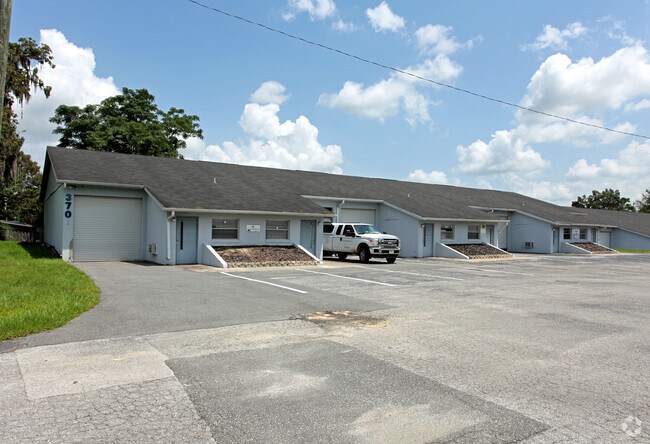
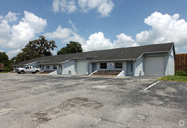
Property Record
3675 Ne 36Th Ave, Ocala, FL 34479
NEARBY LISTINGS FOR SALE OR LEASE
-
-
No Photo
-
-
-
-
-
-
View all Ocala listings for sale on LoopNet.com
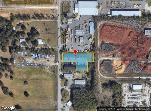
Property Detail
3675 Ne 36Th Ave
Ocala, FL
Citrus Drive Industrial Park
1585-004-000
SEC 35 TWP 14 RGE 22 PLAT BOOK T PAGE 006 CITRUS DRIVE INDUSTRIAL PARK LOT 4 & E 160 FT LOT 5
Warehouse
Marion
X
Florida
12083C0530E
4
2025
1.68 AC
2025
Outlying Marion County
001302
Ocala
25,566 SF
DEMOGRAPHICS near 3675 Ne 36Th Ave
1 Mile
3 Mile
5 Mile
2024 Total Population
3,378
33,275
74,921
2029 Population
3,780
37,433
84,346
Pop Growth 2024-2029
+ 11.90%
+ 12.50%
+ 12.58%
Average Age
43
41
41
2024 Total Households
1,465
14,056
30,792
HH Growth 2024-2029
+ 11.81%
+ 12.49%
+ 12.57%
Median Household Inc
$54,241
$50,206
$54,033
Avg Household Size
2.30
2.30
2.40
2024 Avg HH Vehicles
2.00
2.00
2.00
Median Home Value
$135,164
$157,705
$182,985
Median Year Built
1984
1981
1981
Nearby Places
Map Layers
Map Styles
 Street
 Aerial
- Restaurants
- Banks
- Shops
- Fitness
- Groceries
SALE & LEASE HISTORY
LISTING DATE
SALE/LEASE

Oct 05, 2018
For Sale
Dec 01, 2016
For Lease
Nearby Properties
Address
Land Use
TOTAL SIZE
Lot Size
Zoning
Address
Land Use
TOTAL SIZE
Lot Size
Zoning
205,664 SF
22.56 AC
B5
Address
Land Use
TOTAL SIZE
Lot Size
Zoning
116,035 SF
38.20 AC
GU
Address
Land Use
TOTAL SIZE
Lot Size
Zoning
111,395 SF
13 AC
B2
Address
Land Use
TOTAL SIZE
Lot Size
Zoning
30,334 SF
34.53 AC
GU
Address
Land Use
TOTAL SIZE
Lot Size
Zoning
78,280 SF
12.54 AC
R3
Address
Land Use
TOTAL SIZE
Lot Size
Zoning
203,940 SF
29.65 AC
SC
Address
Land Use
TOTAL SIZE
Lot Size
Zoning
134,827 SF
14.83 AC
SC
Address
Land Use
TOTAL SIZE
Lot Size
Zoning
2,541.29 AC
A1
Address
Land Use
TOTAL SIZE
Lot Size
Zoning
192,553 SF
21.18 AC
SC
Address
Land Use
TOTAL SIZE
Lot Size
Zoning
107,993 SF
66.76 AC
GU
Address
Land Use
TOTAL SIZE
Lot Size
Zoning
10,552 SF
51.60 AC
PRV
Address
Land Use
TOTAL SIZE
Lot Size
Zoning
134,890 SF
18.90 AC
B4
Address
Land Use
TOTAL SIZE
Lot Size
Zoning
35,356 SF
6.14 AC
R3
Address
Land Use
TOTAL SIZE
Lot Size
Zoning
81,689 SF
11.05 AC
B2
Address
Land Use
TOTAL SIZE
Lot Size
Zoning
81,174 SF
18.50 AC
B2
Address
Land Use
TOTAL SIZE
Lot Size
Zoning
22,083 SF
216.46 AC
B2
Address
Land Use
TOTAL SIZE
Lot Size
Zoning
47,567 SF
12 AC
INST
Address
Land Use
TOTAL SIZE
Lot Size
Zoning
27,949 SF
6.03 AC
R3
Address
Land Use
TOTAL SIZE
Lot Size
Zoning
14,344 SF
3.12 AC
B2
Address
Land Use
TOTAL SIZE
Lot Size
Zoning
39,552 SF
5.97 AC
R3
Address
Land Use
TOTAL SIZE
Lot Size
Zoning
36,064 SF
5.31 AC
R3
Address
Land Use
TOTAL SIZE
Lot Size
Zoning
91,003 SF
6.31 AC
B1
Address
Land Use
TOTAL SIZE
Lot Size
Zoning
60,099 SF
52.96 AC
B2
Address
Land Use
TOTAL SIZE
Lot Size
Zoning
98,080 SF
6.69 AC
M1
Address
Land Use
TOTAL SIZE
Lot Size
Zoning
125,469 SF
6.96 AC
M1
Address
Land Use
TOTAL SIZE
Lot Size
Zoning
78,751 SF
20 AC
GU
Address
Land Use
TOTAL SIZE
Lot Size
Zoning
30,082 SF
7.92 AC
PUD
Address
Land Use
TOTAL SIZE
Lot Size
Zoning
76,132 SF
9.40 AC
R3
Address
Land Use
TOTAL SIZE
Lot Size
Zoning
67,409 SF
7.13 AC
B4
Address
Land Use
TOTAL SIZE
Lot Size
Zoning
18,564 SF
3.25 AC
INST
The World's #1 Commercial Real Estate Marketplace
Connect with us
© 2026 CoStar Group
The information above has been obtained from sources believed reliable. While we do not doubt its accuracy we have not verified it and make no guarantee, warranty or representation about it. It is your responsibility to independently confirm its accuracy and completeness. Any projections, opinions, assumptions, or estimates used are for example only and do not represent the current or future performance of the property. The value of this transaction to you depends on tax and other factors which should be evaluated by your tax, financial, and legal advisors. You and your advisors should conduct a careful, independent investigation of the property to determine to your satisfaction the suitability of the property for your needs.