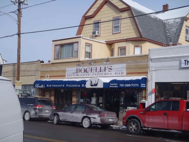
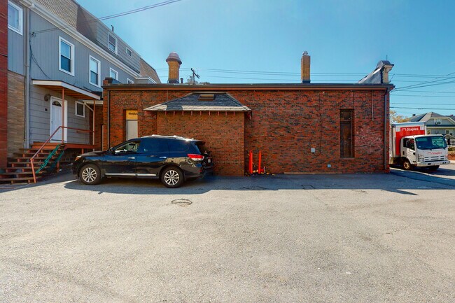
Property Record
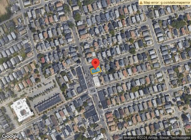
368 Main St, Medford, MA 02155
NEARBY LISTINGS FOR SALE OR LEASE
Property Detail
368 Main St
Storebuilding
Middlesex
X
Massachusetts
25017C0438F
0.10 AC
2025
Medford/Malden
2025
Boston
339700
Boston-Cambridge-Newton, MA-NH
2,379 SF
MEDF-000009-000000-V000121
DEMOGRAPHICS near 368 Main St
1 Mile
3 Mile
5 Mile
2024 Total Population
43,493
317,611
880,355
2029 Population
42,225
310,346
856,188
Pop Growth 2024-2029
(2.92%)
(2.29%)
(2.75%)
Average Age
35
38
38
2024 Total Households
17,131
133,749
365,837
HH Growth 2024-2029
(3.15%)
(2.32%)
(2.87%)
Median Household Inc
$114,307
$107,890
$99,936
Avg Household Size
2.30
2.20
2.20
2024 Avg HH Vehicles
1.00
1.00
1.00
Median Home Value
$766,788
$802,780
$803,219
Median Year Built
1947
1948
1949
Nearby Places
Map Layers
Map Styles
 Street
 Aerial
- Restaurants
- Banks
- Shops
- Fitness
- Groceries
PUBLIC TRANSPORTATION
TRANSIT/SUBWAY
Ball Square (Green Line B - MBTA, Green Line C - MBTA, Green Line D - MBTA, Green Line E - MBTA)
DRIVE
WALK
Distance
Ball Square (Green Line B - MBTA, Green Line C - MBTA, Green Line D - MBTA, Green Line E - MBTA)
2 min
13 min
0.7 mi
Medford/Tufts (Green Line B - MBTA, Green Line C - MBTA, Green Line D - MBTA, Green Line E - MBTA)
DRIVE
WALK
Distance
Medford/Tufts (Green Line B - MBTA, Green Line C - MBTA, Green Line D - MBTA, Green Line E - MBTA)
2 min
14 min
0.7 mi
Magoun Square (Green Line B - MBTA, Green Line C - MBTA, Green Line D - MBTA, Green Line E - MBTA)
DRIVE
WALK
Distance
Magoun Square (Green Line B - MBTA, Green Line C - MBTA, Green Line D - MBTA, Green Line E - MBTA)
3 min
19 min
1.0 mi
Davis Station (Red Line - Massachusetts Bay Transportation Authority Subway (The T))
DRIVE
WALK
Distance
Davis Station (Red Line - Massachusetts Bay Transportation Authority Subway (The T))
2 min
20 min
1.0 mi
COMMUTER RAIL
West Medford (Lowell Line - Massachusetts Bay Transportation Authority Commuter Rail (Purple Line))
DRIVE
WALK
Distance
West Medford (Lowell Line - Massachusetts Bay Transportation Authority Commuter Rail (Purple Line))
5 min
2.5 mi
Porter Square (Fitchburg/South Acton Line - Massachusetts Bay Transportation Authority Commuter Rail (Purple Line))
DRIVE
WALK
Distance
Porter Square (Fitchburg/South Acton Line - Massachusetts Bay Transportation Authority Commuter Rail (Purple Line))
6 min
2.5 mi
AIRPORT
General Edward Lawrence Logan International
DRIVE
WALK
Distance
General Edward Lawrence Logan International
13 min
7.1 mi
Freight Ports
Port of Boston
DRIVE
WALK
Distance
Port of Boston
14 min
6.9 mi
SALE & LEASE HISTORY
LISTING DATE
SALE/LEASE

Apr 30, 2021
For Sale
Apr 13, 2018
For Sale
Nearby Properties
Address
Land Use
TOTAL SIZE
Lot Size
Zoning
Address
Land Use
TOTAL SIZE
Lot Size
Zoning
125,571 SF
3.25 AC
C-3
Address
Land Use
TOTAL SIZE
Lot Size
Zoning
530,200 SF
62.08 AC
E
Address
Land Use
TOTAL SIZE
Lot Size
Zoning
173,400 SF
1.14 AC
MXD
Address
Land Use
TOTAL SIZE
Lot Size
Zoning
142,458 SF
1.67 AC
C-3
Address
Land Use
TOTAL SIZE
Lot Size
Zoning
304,349 SF
1.72 AC
Address
Land Use
TOTAL SIZE
Lot Size
Zoning
283,554 SF
2.76 AC
O-2A
Address
Land Use
TOTAL SIZE
Lot Size
Zoning
54,500 SF
4.01 AC
O-2A
Address
Land Use
TOTAL SIZE
Lot Size
Zoning
47.67 AC
UN
Address
Land Use
TOTAL SIZE
Lot Size
Zoning
4,355 SF
13.12 AC
E
Address
Land Use
TOTAL SIZE
Lot Size
Zoning
646,546 SF
89.28 AC
ROD
Address
Land Use
TOTAL SIZE
Lot Size
Zoning
386,825 SF
10.67 AC
Address
Land Use
TOTAL SIZE
Lot Size
Zoning
2.87 AC
O-2A
Address
Land Use
TOTAL SIZE
Lot Size
Zoning
155,818 SF
5.33 AC
OS
Address
Land Use
TOTAL SIZE
Lot Size
Zoning
213,834 SF
1.48 AC
SD-4
Address
Land Use
TOTAL SIZE
Lot Size
Zoning
569,990 SF
0.46 AC
HR
Address
Land Use
TOTAL SIZE
Lot Size
Zoning
410,642 SF
4.68 AC
CTED
Address
Land Use
TOTAL SIZE
Lot Size
Zoning
2.25 AC
SD-12
Address
Land Use
TOTAL SIZE
Lot Size
Zoning
224,115 SF
2.35 AC
O-2A
Address
Land Use
TOTAL SIZE
Lot Size
Zoning
282,112 SF
2.51 AC
IA-1
Address
Land Use
TOTAL SIZE
Lot Size
Zoning
244,008 SF
4 AC
SD-4A
Address
Land Use
TOTAL SIZE
Lot Size
Zoning
174,764 SF
1.83 AC
C-3
Address
Land Use
TOTAL SIZE
Lot Size
Zoning
17,788 SF
8.32 AC
C-1
Address
Land Use
TOTAL SIZE
Lot Size
Zoning
110,299 SF
0.82 AC
C-3
Address
Land Use
TOTAL SIZE
Lot Size
Zoning
43.90 AC
Address
Land Use
TOTAL SIZE
Lot Size
Zoning
Address
Land Use
TOTAL SIZE
Lot Size
Zoning
530,113 SF
29.43 AC
Address
Land Use
TOTAL SIZE
Lot Size
Zoning
140,205 SF
0.83 AC
IB
Address
Land Use
TOTAL SIZE
Lot Size
Zoning
1.28 AC
C-3
Address
Land Use
TOTAL SIZE
Lot Size
Zoning
13.48 AC
Address
Land Use
TOTAL SIZE
Lot Size
Zoning
125,712 SF
1.20 AC
O-2
The World's #1 Commercial Real Estate Marketplace
Connect with us
© 2026 CoStar Group
The information above has been obtained from sources believed reliable. While we do not doubt its accuracy we have not verified it and make no guarantee, warranty or representation about it. It is your responsibility to independently confirm its accuracy and completeness. Any projections, opinions, assumptions, or estimates used are for example only and do not represent the current or future performance of the property. The value of this transaction to you depends on tax and other factors which should be evaluated by your tax, financial, and legal advisors. You and your advisors should conduct a careful, independent investigation of the property to determine to your satisfaction the suitability of the property for your needs.