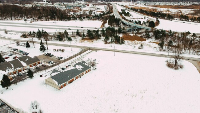
Property Record
368 Blackbrook Rd, Painesville, OH 44077


Current Lease Availabilities
NEARBY LISTINGS FOR SALE OR LEASE
Property Detail
368 Blackbrook Rd
Cleveland-Elyria, OH
Blackbrook Road Industrial Park
11-B-064-A-00-022
LOT 17, 18, 19 & 20 TRACT 4 PART OF S/L 15
Officebuilding
Lake
X
Ohio
39085C0106G
17
0
1 AC
2024
Northeast
206200
Cleveland
6,230 SF
DEMOGRAPHICS near 368 Blackbrook Rd
1 Mile
3 Mile
5 Mile
2024 Total Population
4,039
44,164
92,484
2029 Population
4,122
44,082
92,166
Pop Growth 2024-2029
+ 2.05%
(0.19%)
(0.34%)
Average Age
40
41
43
2024 Total Households
1,617
17,852
38,321
HH Growth 2024-2029
+ 2.04%
(0.25%)
(0.40%)
Median Household Inc
$86,538
$68,832
$77,954
Avg Household Size
2.50
2.40
2.30
2024 Avg HH Vehicles
2.00
2.00
2.00
Median Home Value
$207,371
$171,556
$189,652
Median Year Built
1998
1968
1974
Nearby Places
Map Layers
Map Styles
 Street
 Aerial
- Restaurants
- Banks
- Shops
- Fitness
- Groceries
PUBLIC TRANSPORTATION
AIRPORT
Cleveland-Hopkins International
DRIVE
WALK
Distance
Cleveland-Hopkins International
57 min
40.7 mi
Nearby Properties
Address
Land Use
TOTAL SIZE
Lot Size
Zoning
Address
Land Use
TOTAL SIZE
Lot Size
Zoning
15.89 AC
Address
Land Use
TOTAL SIZE
Lot Size
Zoning
241,548 SF
22.28 AC
Address
Land Use
TOTAL SIZE
Lot Size
Zoning
160,976 SF
3.31 AC
B-4
Address
Land Use
TOTAL SIZE
Lot Size
Zoning
165,749 SF
8 AC
R-1
Address
Land Use
TOTAL SIZE
Lot Size
Zoning
89,317 SF
7.64 AC
Address
Land Use
TOTAL SIZE
Lot Size
Zoning
78,850 SF
Address
Land Use
TOTAL SIZE
Lot Size
Zoning
57,904 SF
3.61 AC
Address
Land Use
TOTAL SIZE
Lot Size
Zoning
580,720 SF
22.25 AC
R-4
Address
Land Use
TOTAL SIZE
Lot Size
Zoning
16,955 SF
69.10 AC
B3
Address
Land Use
TOTAL SIZE
Lot Size
Zoning
197,433 SF
26.82 AC
R-1
Address
Land Use
TOTAL SIZE
Lot Size
Zoning
113,375 SF
2.73 AC
B-3
Address
Land Use
TOTAL SIZE
Lot Size
Zoning
13.60 AC
Address
Land Use
TOTAL SIZE
Lot Size
Zoning
82,044 SF
8.79 AC
Address
Land Use
TOTAL SIZE
Lot Size
Zoning
111,506 SF
9.84 AC
Address
Land Use
TOTAL SIZE
Lot Size
Zoning
137,183 SF
12.35 AC
Address
Land Use
TOTAL SIZE
Lot Size
Zoning
198,502 SF
39.56 AC
Address
Land Use
TOTAL SIZE
Lot Size
Zoning
Address
Land Use
TOTAL SIZE
Lot Size
Zoning
57,744 SF
3.29 AC
Address
Land Use
TOTAL SIZE
Lot Size
Zoning
163,586 SF
24.91 AC
Address
Land Use
TOTAL SIZE
Lot Size
Zoning
59,448 SF
Address
Land Use
TOTAL SIZE
Lot Size
Zoning
188,875 SF
25.67 AC
M-2
Address
Land Use
TOTAL SIZE
Lot Size
Zoning
138,290 SF
1.73 AC
M-1
Address
Land Use
TOTAL SIZE
Lot Size
Zoning
159,126 SF
12.79 AC
C-1
Address
Land Use
TOTAL SIZE
Lot Size
Zoning
Address
Land Use
TOTAL SIZE
Lot Size
Zoning
122,256 SF
11.73 AC
B-2
Address
Land Use
TOTAL SIZE
Lot Size
Zoning
196,026 SF
23 AC
B-2
Address
Land Use
TOTAL SIZE
Lot Size
Zoning
Address
Land Use
TOTAL SIZE
Lot Size
Zoning
400,874 SF
26.37 AC
I-2
Address
Land Use
TOTAL SIZE
Lot Size
Zoning
136,138 SF
15.25 AC
Address
Land Use
TOTAL SIZE
Lot Size
Zoning
51,672 SF
The World's #1 Commercial Real Estate Marketplace
Connect with us
© 2025 CoStar Group
The information above has been obtained from sources believed reliable. While we do not doubt its accuracy we have not verified it and make no guarantee, warranty or representation about it. It is your responsibility to independently confirm its accuracy and completeness. Any projections, opinions, assumptions, or estimates used are for example only and do not represent the current or future performance of the property. The value of this transaction to you depends on tax and other factors which should be evaluated by your tax, financial, and legal advisors. You and your advisors should conduct a careful, independent investigation of the property to determine to your satisfaction the suitability of the property for your needs.