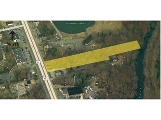
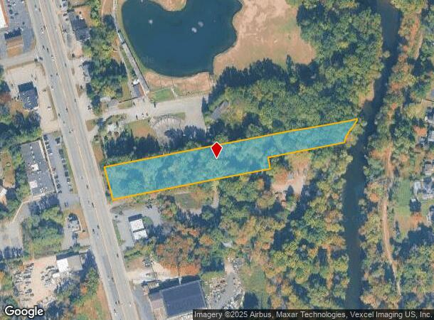
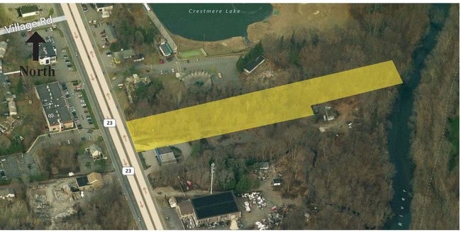
Property Record
368 State Rt 23, Pompton Plains, NJ 07444

NEARBY LISTINGS FOR SALE OR LEASE
-
-
No Photo
-
-
-
View all Pompton Plains listings for sale on LoopNet.com
Property Detail
368 State Rt 23
Newark, NJ-PA
FACILITY NAME: VACANT LAND
31-02702-0000-00005
Morris
Governmentalpublicusegeneral
New Jersey
AE
5
34027C0183F
2.86 AC
2023
Eastern Morris
2025
Northern New Jersey
040200
DEMOGRAPHICS near 368 State Rt 23
1 Mile
3 Mile
5 Mile
2024 Total Population
8,312
63,839
144,934
2029 Population
8,305
63,587
144,257
Pop Growth 2024-2029
(0.08%)
(0.39%)
(0.47%)
Average Age
42
43
43
2024 Total Households
2,690
23,408
52,491
HH Growth 2024-2029
(0.19%)
(0.61%)
(0.63%)
Median Household Inc
$132,514
$128,931
$122,065
Avg Household Size
2.90
2.70
2.60
2024 Avg HH Vehicles
2.00
2.00
2.00
Median Home Value
$486,769
$498,202
$484,543
Median Year Built
1958
1966
1966
Nearby Places
Map Layers
Map Styles
 Street
 Aerial
- Restaurants
- Banks
- Shops
- Fitness
- Groceries
PUBLIC TRANSPORTATION
COMMUTER RAIL
Lincoln Park (Montclair-Boonton Line - NJ Transit Commuter Rail (NJ Transit))
DRIVE
WALK
Distance
Lincoln Park (Montclair-Boonton Line - NJ Transit Commuter Rail (NJ Transit))
9 min
4.5 mi
Mountain View (Montclair-Boonton Line - NJ Transit Commuter Rail (NJ Transit))
DRIVE
WALK
Distance
Mountain View (Montclair-Boonton Line - NJ Transit Commuter Rail (NJ Transit))
7 min
5.1 mi
AIRPORT
Newark Liberty International
DRIVE
WALK
Distance
Newark Liberty International
32 min
27.2 mi
LaGuardia
DRIVE
WALK
Distance
LaGuardia
48 min
35.3 mi
Freight Ports
Port Newark Container Terminal
DRIVE
WALK
Distance
Port Newark Container Terminal
38 min
26.6 mi
SALE & LEASE HISTORY
LISTING DATE
SALE/LEASE

Sep 24, 2016
For Sale
Nearby Properties
Address
Land Use
TOTAL SIZE
Lot Size
Zoning
Address
Land Use
TOTAL SIZE
Lot Size
Zoning
143.16 AC
PUD
Address
Land Use
TOTAL SIZE
Lot Size
Zoning
21.99 AC
H
Address
Land Use
TOTAL SIZE
Lot Size
Zoning
49,701 SF
29.34 AC
GAR
Address
Land Use
TOTAL SIZE
Lot Size
Zoning
10.88 AC
Address
Land Use
TOTAL SIZE
Lot Size
Zoning
18.76 AC
C-3
Address
Land Use
TOTAL SIZE
Lot Size
Zoning
264,080 SF
44.44 AC
HB
Address
Land Use
TOTAL SIZE
Lot Size
Zoning
32.21 AC
R-15
Address
Land Use
TOTAL SIZE
Lot Size
Zoning
5,880 SF
17.46 AC
I
Address
Land Use
TOTAL SIZE
Lot Size
Zoning
334,755 SF
107.89 AC
Address
Land Use
TOTAL SIZE
Lot Size
Zoning
41.71 AC
C-4
Address
Land Use
TOTAL SIZE
Lot Size
Zoning
97,631 SF
10.01 AC
B-2
Address
Land Use
TOTAL SIZE
Lot Size
Zoning
131,306 SF
14.40 AC
HB
Address
Land Use
TOTAL SIZE
Lot Size
Zoning
259,919 SF
48.14 AC
Address
Land Use
TOTAL SIZE
Lot Size
Zoning
9.08 AC
H-C
Address
Land Use
TOTAL SIZE
Lot Size
Zoning
7.58 AC
R-4
Address
Land Use
TOTAL SIZE
Lot Size
Zoning
9.28 AC
R-11
Address
Land Use
TOTAL SIZE
Lot Size
Zoning
10.07 AC
R-15
Address
Land Use
TOTAL SIZE
Lot Size
Zoning
143,500 SF
14.73 AC
I
Address
Land Use
TOTAL SIZE
Lot Size
Zoning
12.24 AC
H-C
Address
Land Use
TOTAL SIZE
Lot Size
Zoning
6.30 AC
I-2
Address
Land Use
TOTAL SIZE
Lot Size
Zoning
82,061 SF
12.39 AC
R-15
Address
Land Use
TOTAL SIZE
Lot Size
Zoning
634 SF
14.76 AC
H
Address
Land Use
TOTAL SIZE
Lot Size
Zoning
6.95 AC
I-2
Address
Land Use
TOTAL SIZE
Lot Size
Zoning
2,511 SF
17.63 AC
Address
Land Use
TOTAL SIZE
Lot Size
Zoning
357,779 SF
16.98 AC
Address
Land Use
TOTAL SIZE
Lot Size
Zoning
34.77 AC
R-15
Address
Land Use
TOTAL SIZE
Lot Size
Zoning
5.89 AC
R-9
Address
Land Use
TOTAL SIZE
Lot Size
Zoning
434 SF
53.04 AC
I-3
Address
Land Use
TOTAL SIZE
Lot Size
Zoning
145,639 SF
27.40 AC
Address
Land Use
TOTAL SIZE
Lot Size
Zoning
103,650 SF
4.81 AC
I-1
The World's #1 Commercial Real Estate Marketplace
Connect with us
© 2025 CoStar Group
The information above has been obtained from sources believed reliable. While we do not doubt its accuracy we have not verified it and make no guarantee, warranty or representation about it. It is your responsibility to independently confirm its accuracy and completeness. Any projections, opinions, assumptions, or estimates used are for example only and do not represent the current or future performance of the property. The value of this transaction to you depends on tax and other factors which should be evaluated by your tax, financial, and legal advisors. You and your advisors should conduct a careful, independent investigation of the property to determine to your satisfaction the suitability of the property for your needs.