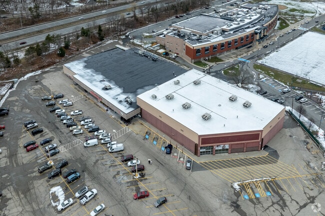
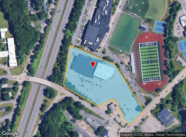
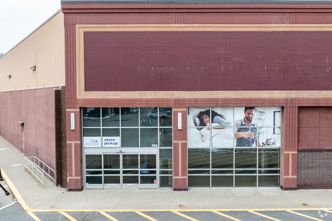
Property Record
368 Southbridge St, Auburn, MA 01501
NEARBY LISTINGS FOR SALE OR LEASE
Property Detail
368 Southbridge St
AUBU-000033-000000-000081
Worcester
Commercialnec
Massachusetts
X
81
25027C0804E
6.03 AC
2025
Worcester Metro
2025
Boston
736300
Worcester, MA-CT
1,120 SF
DEMOGRAPHICS near 368 Southbridge St
1 Mile
3 Mile
5 Mile
2024 Total Population
6,003
45,480
163,379
2029 Population
6,007
45,061
161,363
Pop Growth 2024-2029
+ 0.07%
(0.92%)
(1.23%)
Average Age
43
40
39
2024 Total Households
2,366
17,001
63,022
HH Growth 2024-2029
(0.04%)
(0.94%)
(1.19%)
Median Household Inc
$104,946
$74,409
$62,327
Avg Household Size
2.50
2.40
2.40
2024 Avg HH Vehicles
2.00
2.00
1.00
Median Home Value
$333,241
$317,460
$323,414
Median Year Built
1957
1954
1950
Nearby Places
Map Layers
Map Styles
 Street
 Aerial
- Restaurants
- Banks
- Shops
- Fitness
- Groceries
PUBLIC TRANSPORTATION
COMMUTER RAIL
Worcester Union Station (Lake Shore Limited - Amtrak)
DRIVE
WALK
Distance
Worcester Union Station (Lake Shore Limited - Amtrak)
9 min
5.1 mi
Worcester (Framingham/Worcester Line - Massachusetts Bay Transportation Authority Commuter Rail (Purple Line))
DRIVE
WALK
Distance
Worcester (Framingham/Worcester Line - Massachusetts Bay Transportation Authority Commuter Rail (Purple Line))
9 min
5.3 mi
AIRPORT
Worcester Regional
DRIVE
WALK
Distance
Worcester Regional
17 min
6.8 mi
Freight Ports
Port of Boston
DRIVE
WALK
Distance
Port of Boston
64 min
46.8 mi
SALE & LEASE HISTORY
LISTING DATE
SALE/LEASE

Nov 06, 2023
For Lease
Nearby Properties
Address
Land Use
TOTAL SIZE
Lot Size
Zoning
Address
Land Use
TOTAL SIZE
Lot Size
Zoning
244,486 SF
42.64 AC
RL-7
Address
Land Use
TOTAL SIZE
Lot Size
Zoning
142.98 AC
Address
Land Use
TOTAL SIZE
Lot Size
Zoning
25,000 SF
99.10 AC
MG-.5
Address
Land Use
TOTAL SIZE
Lot Size
Zoning
1,760 SF
105.54 AC
ML10
Address
Land Use
TOTAL SIZE
Lot Size
Zoning
164,378 SF
21.40 AC
Address
Land Use
TOTAL SIZE
Lot Size
Zoning
591,515 SF
33.04 AC
MG-1
Address
Land Use
TOTAL SIZE
Lot Size
Zoning
69.46 AC
RS-7
Address
Land Use
TOTAL SIZE
Lot Size
Zoning
159,355 SF
207.62 AC
RL-7
Address
Land Use
TOTAL SIZE
Lot Size
Zoning
3.43 AC
ML10
Address
Land Use
TOTAL SIZE
Lot Size
Zoning
118,112 SF
6.54 AC
Address
Land Use
TOTAL SIZE
Lot Size
Zoning
41.84 AC
Address
Land Use
TOTAL SIZE
Lot Size
Zoning
36.67 AC
Address
Land Use
TOTAL SIZE
Lot Size
Zoning
279,977 SF
17.80 AC
Address
Land Use
TOTAL SIZE
Lot Size
Zoning
200 SF
50.14 AC
MG-2
Address
Land Use
TOTAL SIZE
Lot Size
Zoning
14.66 AC
BG-2
Address
Land Use
TOTAL SIZE
Lot Size
Zoning
92,604 SF
1 AC
Address
Land Use
TOTAL SIZE
Lot Size
Zoning
210,001 SF
13.14 AC
Address
Land Use
TOTAL SIZE
Lot Size
Zoning
70,400 SF
17.10 AC
Address
Land Use
TOTAL SIZE
Lot Size
Zoning
8.77 AC
BL-1
Address
Land Use
TOTAL SIZE
Lot Size
Zoning
95,184 SF
2.44 AC
BL-1
Address
Land Use
TOTAL SIZE
Lot Size
Zoning
13,417 SF
28.90 AC
MG-.5
Address
Land Use
TOTAL SIZE
Lot Size
Zoning
93,548 SF
1.43 AC
BL-1
Address
Land Use
TOTAL SIZE
Lot Size
Zoning
169,822 SF
18.80 AC
RL-7
Address
Land Use
TOTAL SIZE
Lot Size
Zoning
21.72 AC
Address
Land Use
TOTAL SIZE
Lot Size
Zoning
29.34 AC
RS-7
Address
Land Use
TOTAL SIZE
Lot Size
Zoning
124,100 SF
5.03 AC
RG-5
Address
Land Use
TOTAL SIZE
Lot Size
Zoning
199,424 SF
12.97 AC
ML-.5
Address
Land Use
TOTAL SIZE
Lot Size
Zoning
4.51 AC
RS-7
Address
Land Use
TOTAL SIZE
Lot Size
Zoning
130,496 SF
4.38 AC
BG-3
The World's #1 Commercial Real Estate Marketplace
Connect with us
© 2026 CoStar Group
The information above has been obtained from sources believed reliable. While we do not doubt its accuracy we have not verified it and make no guarantee, warranty or representation about it. It is your responsibility to independently confirm its accuracy and completeness. Any projections, opinions, assumptions, or estimates used are for example only and do not represent the current or future performance of the property. The value of this transaction to you depends on tax and other factors which should be evaluated by your tax, financial, and legal advisors. You and your advisors should conduct a careful, independent investigation of the property to determine to your satisfaction the suitability of the property for your needs.