Property Record
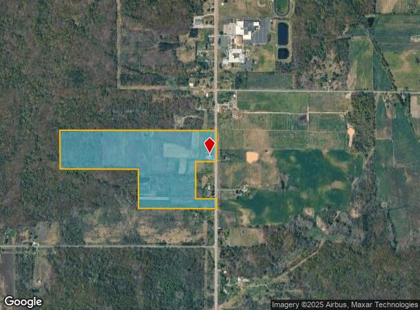
36800 M 140 Hwy, Covert, MI 49043

NEARBY LISTINGS FOR SALE OR LEASE
-
-
View all Covert listings for sale on LoopNet.com
Property Detail
36800 M 140 Hwy
80-07-022-018-30
353-B1 22-2-17 889-452 976-399,400 1092-447 1460-160 S 39 ACRES OF N 1/2 OF NE 1/4 OF SEC. ALSO N 1/2 OF SE 1/4 OF NE 1/4 OF
Agriculturalland
Van Buren
X
Michigan
26159C0142C
53.21 AC
2024
Van Buren County
2025
West Michigan
010600
DEMOGRAPHICS near 36800 M 140 Hwy
1 mile
3 mile
5 mile
2024 Total Population
365
2,119
7,113
2029 Population
376
2,167
7,280
Pop Growth 2024-2029
+ 3.01%
+ 2.27%
+ 2.35%
Average Age
40
40
41
2024 Total Households
132
766
2,720
HH Growth 2024-2029
+ 3.03%
+ 2.09%
+ 2.17%
Median Household Inc
$30,139
$31,201
$41,724
Avg Household Size
2.70
2.70
2.50
2024 Avg HH Vehicles
2.00
2.00
2.00
Median Home Value
$128,333
$138,418
$156,761
Median Year Built
1971
1972
1972
Nearby Places
Map Layers
Map Styles
 Street
 Aerial
Transit
 Traffic
 Biking
Places
Listings with unknown addresses are not visible on the map
- Restaurants
- Banks
- Shops
- Fitness
- Groceries
PUBLIC TRANSPORTATION
COMMUTER RAIL
Bangor Amtrak Station (Pere Marquette - Amtrak)
Drive
Walk
Distance
Bangor Amtrak Station (Pere Marquette - Amtrak)
23 min
9.8 mi
Freight Ports
Port Milwaukee
Drive
Walk
Distance
Port Milwaukee
242 min
200.4 mi
SALE & LEASE HISTORY
LISTING DATE
SALE/LEASE

Jan 28, 2021
For Sale
Nearby Properties
Address
Land Use
TOTAL SIZE
Lot Size
Zoning
Address
Land Use
TOTAL SIZE
Lot Size
Zoning
43,414 SF
71.10 AC
HC
Address
Land Use
TOTAL SIZE
Lot Size
Zoning
67,500 SF
10 AC
RR
Address
Land Use
TOTAL SIZE
Lot Size
Zoning
6,926 SF
2.73 AC
Address
Land Use
TOTAL SIZE
Lot Size
Zoning
3,589 SF
3.26 AC
RR
Address
Land Use
TOTAL SIZE
Lot Size
Zoning
2,028 SF
103.20 AC
RR
Address
Land Use
TOTAL SIZE
Lot Size
Zoning
2,303 SF
0.86 AC
LD-1
Address
Land Use
TOTAL SIZE
Lot Size
Zoning
3,415 SF
2.62 AC
RR
Address
Land Use
TOTAL SIZE
Lot Size
Zoning
3,304 SF
2.65 AC
RR
Address
Land Use
TOTAL SIZE
Lot Size
Zoning
2,554 SF
2.50 AC
RR
Address
Land Use
TOTAL SIZE
Lot Size
Zoning
3,449 SF
2.50 AC
RR
Address
Land Use
TOTAL SIZE
Lot Size
Zoning
9,100 SF
3 AC
MIX-2
Address
Land Use
TOTAL SIZE
Lot Size
Zoning
2,503 SF
5 AC
LD-2
Address
Land Use
TOTAL SIZE
Lot Size
Zoning
1,912 SF
2.86 AC
RR
Address
Land Use
TOTAL SIZE
Lot Size
Zoning
2,268 SF
118 AC
AG
Address
Land Use
TOTAL SIZE
Lot Size
Zoning
2,150 SF
2.92 AC
RR
Address
Land Use
TOTAL SIZE
Lot Size
Zoning
2,319 SF
60 AC
MIX-2
Address
Land Use
TOTAL SIZE
Lot Size
Zoning
1,220 SF
79.20 AC
AG
Address
Land Use
TOTAL SIZE
Lot Size
Zoning
153 AC
AG
Address
Land Use
TOTAL SIZE
Lot Size
Zoning
1,764 SF
2.50 AC
RR
Address
Land Use
TOTAL SIZE
Lot Size
Zoning
1,866 SF
40 AC
AG
Address
Land Use
TOTAL SIZE
Lot Size
Zoning
2,208 SF
2.94 AC
RR
Address
Land Use
TOTAL SIZE
Lot Size
Zoning
3,297 SF
113.89 AC
LD-2
Address
Land Use
TOTAL SIZE
Lot Size
Zoning
1,842 SF
2.50 AC
RR
Address
Land Use
TOTAL SIZE
Lot Size
Zoning
26,612 SF
10 AC
I
Address
Land Use
TOTAL SIZE
Lot Size
Zoning
1,708 SF
98.70 AC
AG
Address
Land Use
TOTAL SIZE
Lot Size
Zoning
16.30 AC
HIGH DENSE
Address
Land Use
TOTAL SIZE
Lot Size
Zoning
1,872 SF
55 AC
AG
Address
Land Use
TOTAL SIZE
Lot Size
Zoning
2,009 SF
2.66 AC
RR
Address
Land Use
TOTAL SIZE
Lot Size
Zoning
76.40 AC
NO ZONI
Address
Land Use
TOTAL SIZE
Lot Size
Zoning
2,646 SF
29.50 AC
AG
The World's #1 Commercial Real Estate Marketplace
Connect with us
© 2026 CoStar Group
The information above has been obtained from sources believed reliable. While we do not doubt its accuracy we have not verified it and make no guarantee, warranty or representation about it. It is your responsibility to independently confirm its accuracy and completeness. Any projections, opinions, assumptions, or estimates used are for example only and do not represent the current or future performance of the property. The value of this transaction to you depends on tax and other factors which should be evaluated by your tax, financial, and legal advisors. You and your advisors should conduct a careful, independent investigation of the property to determine to your satisfaction the suitability of the property for your needs.