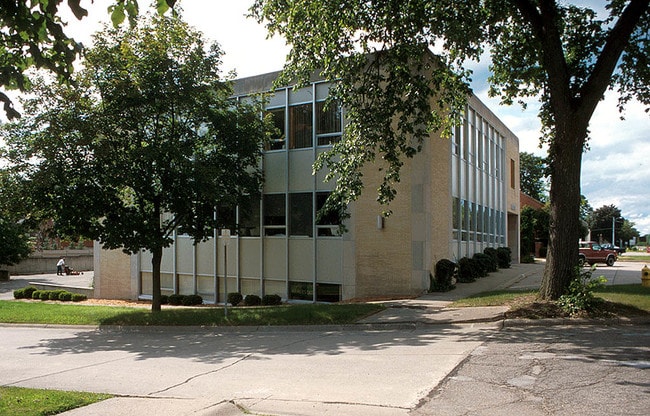
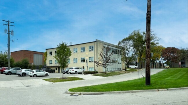
Property Record
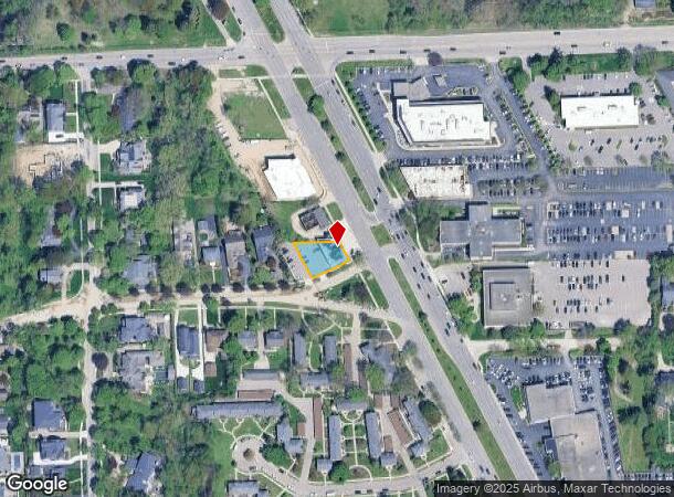
36801 Woodward Ave, Birmingham, MI 48009

NEARBY LISTINGS FOR SALE OR LEASE
Property Detail
36801 Woodward Ave
Detroit-Warren-Dearborn, MI
Quarton Lake Estates
19-25-101-013
T2N, R10E, SEC 25 QUARTON LAKE ESTATES REPLAT LOTS 10, 11 & 12, ALSO VAC PART OF REDDING RD LYING ELY OF WLY LINE OF LOT 10 EXTENDED SELY & NLY OF LINE EXTENDED FROM SE COR OF LOT 10 SWLY TO SE COR OF LOT 46 OF SD SUB
Officebuilding
Oakland
X
Michigan
26125C0536F
10
2024
0.19 AC
2024
Birmingham
152600
Detroit
11,544 SF
DEMOGRAPHICS near 36801 Woodward Ave
1 Mile
3 Mile
5 Mile
2024 Total Population
8,252
69,498
204,377
2029 Population
8,248
68,947
202,604
Pop Growth 2024-2029
(0.05%)
(0.79%)
(0.87%)
Average Age
43
42
43
2024 Total Households
3,177
28,034
85,173
HH Growth 2024-2029
0.00%
(0.77%)
(0.88%)
Median Household Inc
$200,189
$143,295
$108,817
Avg Household Size
2.50
2.40
2.30
2024 Avg HH Vehicles
2.00
2.00
2.00
Median Home Value
$783,068
$546,618
$376,424
Median Year Built
1959
1964
1965
Nearby Places
Map Layers
Map Styles
 Street
 Aerial
- Restaurants
- Banks
- Shops
- Fitness
- Groceries
PUBLIC TRANSPORTATION
COMMUTER RAIL
DRIVE
WALK
Distance
8 min
3.1 mi
DRIVE
WALK
Distance
14 min
7.1 mi
AIRPORT
Detroit Metro Wayne County
DRIVE
WALK
Distance
Detroit Metro Wayne County
53 min
31.9 mi
Windsor International
DRIVE
WALK
Distance
Windsor International
53 min
32.1 mi
SALE & LEASE HISTORY
LISTING DATE
SALE/LEASE

Oct 24, 2019
For Lease
Feb 09, 2023
For Sale
Aug 20, 2024
For Sale
Nearby Properties
Address
Land Use
TOTAL SIZE
Lot Size
Zoning
Address
Land Use
TOTAL SIZE
Lot Size
Zoning
399,735 SF
19.71 AC
B2
Address
Land Use
TOTAL SIZE
Lot Size
Zoning
224,766 SF
19.92 AC
B2
Address
Land Use
TOTAL SIZE
Lot Size
Zoning
111,030 SF
0.97 AC
BI
Address
Land Use
TOTAL SIZE
Lot Size
Zoning
208,296 SF
8.16 AC
OSC
Address
Land Use
TOTAL SIZE
Lot Size
Zoning
149,395 SF
1.02 AC
BI
Address
Land Use
TOTAL SIZE
Lot Size
Zoning
143,160 SF
0.84 AC
BI
Address
Land Use
TOTAL SIZE
Lot Size
Zoning
99,661 SF
0.62 AC
Address
Land Use
TOTAL SIZE
Lot Size
Zoning
427,945 SF
18.26 AC
OSC
Address
Land Use
TOTAL SIZE
Lot Size
Zoning
236,140 SF
1.67 AC
BI
Address
Land Use
TOTAL SIZE
Lot Size
Zoning
301,728 SF
2.83 AC
B2
Address
Land Use
TOTAL SIZE
Lot Size
Zoning
289,110 SF
6.07 AC
BI
Address
Land Use
TOTAL SIZE
Lot Size
Zoning
83,244 SF
0.38 AC
Address
Land Use
TOTAL SIZE
Lot Size
Zoning
154,370 SF
8.80 AC
BI
Address
Land Use
TOTAL SIZE
Lot Size
Zoning
206,913 SF
16.99 AC
O1
Address
Land Use
TOTAL SIZE
Lot Size
Zoning
242,512 SF
6.60 AC
BI
Address
Land Use
TOTAL SIZE
Lot Size
Zoning
279,360 SF
14.34 AC
RM1
Address
Land Use
TOTAL SIZE
Lot Size
Zoning
267,393 SF
11.11 AC
BI
Address
Land Use
TOTAL SIZE
Lot Size
Zoning
84,711 SF
5.05 AC
BI
Address
Land Use
TOTAL SIZE
Lot Size
Zoning
225,890 SF
10.10 AC
OM
Address
Land Use
TOTAL SIZE
Lot Size
Zoning
79,935 SF
1.02 AC
BI
Address
Land Use
TOTAL SIZE
Lot Size
Zoning
109,570 SF
0.68 AC
BI
Address
Land Use
TOTAL SIZE
Lot Size
Zoning
162,080 SF
5.88 AC
OSC
Address
Land Use
TOTAL SIZE
Lot Size
Zoning
275,889 SF
12.34 AC
BI
Address
Land Use
TOTAL SIZE
Lot Size
Zoning
245,740 SF
1.06 AC
BI
Address
Land Use
TOTAL SIZE
Lot Size
Zoning
301,276 SF
13.58 AC
AI
Address
Land Use
TOTAL SIZE
Lot Size
Zoning
80,334 SF
0.57 AC
BI
Address
Land Use
TOTAL SIZE
Lot Size
Zoning
261,180 SF
9 AC
RM2
Address
Land Use
TOTAL SIZE
Lot Size
Zoning
219,274 SF
9.75 AC
BI
Address
Land Use
TOTAL SIZE
Lot Size
Zoning
318,695 SF
12 AC
Address
Land Use
TOTAL SIZE
Lot Size
Zoning
160,535 SF
9.52 AC
OM
The World's #1 Commercial Real Estate Marketplace
Connect with us
© 2025 CoStar Group
The information above has been obtained from sources believed reliable. While we do not doubt its accuracy we have not verified it and make no guarantee, warranty or representation about it. It is your responsibility to independently confirm its accuracy and completeness. Any projections, opinions, assumptions, or estimates used are for example only and do not represent the current or future performance of the property. The value of this transaction to you depends on tax and other factors which should be evaluated by your tax, financial, and legal advisors. You and your advisors should conduct a careful, independent investigation of the property to determine to your satisfaction the suitability of the property for your needs.