Property Record
3681 W Bell Vista Ave, Pahrump, NV 89060
NEARBY LISTINGS FOR SALE OR LEASE
Property Detail
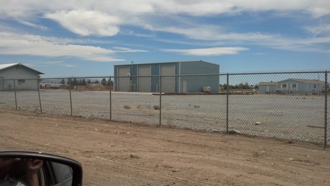
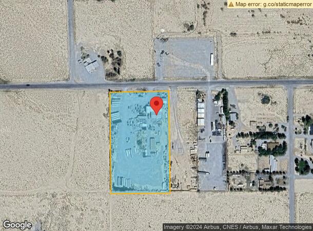
3681 W Bell Vista Ave
Pahrump, NV
Bell Vista U.2
28-231-05
T19S R52E S36 L.10 BELL VISTA UNIT 2
Commercialnec
Nye
X
Nevada
32023C8740F
10
2024
4.70 AC
2025
Carson City/Nevada Area
960416
Other Market Areas
3,200 SF
DEMOGRAPHICS near 3681 W Bell Vista Ave
1 Mile
3 Mile
5 Mile
2024 Total Population
663
5,183
17,958
2029 Population
771
6,031
20,962
Pop Growth 2024-2029
+ 16.29%
+ 16.36%
+ 16.73%
Average Age
49
49
49
2024 Total Households
286
2,208
7,497
HH Growth 2024-2029
+ 16.08%
+ 16.39%
+ 16.90%
Median Household Inc
$47,272
$56,582
$50,794
Avg Household Size
2.30
2.30
2.30
2024 Avg HH Vehicles
2.00
2.00
2.00
Median Home Value
$248,214
$218,509
$206,270
Median Year Built
1997
1995
1996
Nearby Places
Map Layers
Map Styles
 Street
 Aerial
- Restaurants
- Banks
- Shops
- Fitness
- Groceries
SALE & LEASE HISTORY
LISTING DATE
SALE/LEASE

Sep 24, 2016
For Sale
Nearby Properties
Address
Land Use
TOTAL SIZE
Lot Size
Zoning
Address
Land Use
TOTAL SIZE
Lot Size
Zoning
320 AC
R
Address
Land Use
TOTAL SIZE
Lot Size
Zoning
8,320 SF
1.41 AC
NC
Address
Land Use
TOTAL SIZE
Lot Size
Zoning
Address
Land Use
TOTAL SIZE
Lot Size
Zoning
7,488 SF
1.83 AC
NC
Address
Land Use
TOTAL SIZE
Lot Size
Zoning
5,160 SF
4.40 AC
NC
Address
Land Use
TOTAL SIZE
Lot Size
Zoning
8,875 SF
2.33 AC
RE-2
Address
Land Use
TOTAL SIZE
Lot Size
Zoning
50 AC
SPLIT
Address
Land Use
TOTAL SIZE
Lot Size
Zoning
10,760 SF
1.09 AC
CM
Address
Land Use
TOTAL SIZE
Lot Size
Zoning
6,867 SF
10 AC
NC
Address
Land Use
TOTAL SIZE
Lot Size
Zoning
3,410 SF
123.55 AC
RH-4.5
Address
Land Use
TOTAL SIZE
Lot Size
Zoning
8,000 SF
1.90 AC
NC
Address
Land Use
TOTAL SIZE
Lot Size
Zoning
149.09 AC
SPLIT
Address
Land Use
TOTAL SIZE
Lot Size
Zoning
4,688 SF
2.02 AC
GC
Address
Land Use
TOTAL SIZE
Lot Size
Zoning
6,957 SF
4.80 AC
RH-9.5
Address
Land Use
TOTAL SIZE
Lot Size
Zoning
5,000 SF
10 AC
NC
Address
Land Use
TOTAL SIZE
Lot Size
Zoning
2,912 SF
9.02 AC
RH-4.5
Address
Land Use
TOTAL SIZE
Lot Size
Zoning
4,704 SF
2.50 AC
RE-2
Address
Land Use
TOTAL SIZE
Lot Size
Zoning
4,800 SF
2.30 AC
NC
Address
Land Use
TOTAL SIZE
Lot Size
Zoning
132.09 AC
RH-9.5
Address
Land Use
TOTAL SIZE
Lot Size
Zoning
1,000 SF
2.08 AC
VR-20
Address
Land Use
TOTAL SIZE
Lot Size
Zoning
1.93 AC
VR-20
Address
Land Use
TOTAL SIZE
Lot Size
Zoning
2,180 SF
5.34 AC
RH-9.5
Address
Land Use
TOTAL SIZE
Lot Size
Zoning
3,670 SF
2.02 AC
RH-4.5
Address
Land Use
TOTAL SIZE
Lot Size
Zoning
100 AC
RH-4.5
Address
Land Use
TOTAL SIZE
Lot Size
Zoning
8,000 SF
Address
Land Use
TOTAL SIZE
Lot Size
Zoning
2,850 SF
1.10 AC
GC
Address
Land Use
TOTAL SIZE
Lot Size
Zoning
5,600 SF
4.44 AC
NC
Address
Land Use
TOTAL SIZE
Lot Size
Zoning
3,120 SF
2.26 AC
SPLIT
Address
Land Use
TOTAL SIZE
Lot Size
Zoning
2,284 SF
2.30 AC
RE-2
Address
Land Use
TOTAL SIZE
Lot Size
Zoning
4,080 SF
1.11 AC
CM
The World's #1 Commercial Real Estate Marketplace
Connect with us
© 2026 CoStar Group
The information above has been obtained from sources believed reliable. While we do not doubt its accuracy we have not verified it and make no guarantee, warranty or representation about it. It is your responsibility to independently confirm its accuracy and completeness. Any projections, opinions, assumptions, or estimates used are for example only and do not represent the current or future performance of the property. The value of this transaction to you depends on tax and other factors which should be evaluated by your tax, financial, and legal advisors. You and your advisors should conduct a careful, independent investigation of the property to determine to your satisfaction the suitability of the property for your needs.