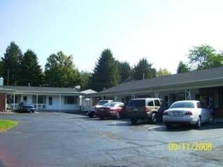
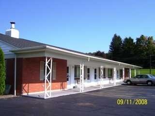
Property Record
3682 Route 430, Bemus Point, NY 14712
Save to a Folder
{{folder.Name}}
{{folder.ListingIds.length}} Properties
{{folder.ListingIds.length}} Property
Create a New Folder
Property Detail
3682 Route 430
Jamestown-Dunkirk, NY
OLD APN: 063689 18-1-1
063689-350-000-0001-022-000
CHAUTAUQUA
Apartment
New York
02 - SINGL
22.000
2025
3.10 AC
2025
New York West Area
036902
Other Market Areas
2,541 SF
NEARBY LISTINGS FOR SALE OR LEASE
-
-
View all Bemus Point listings for sale on LoopNet.com
DEMOGRAPHICS near 3682 Route 430
1 mile
3 mile
5 mile
2025 Total Population
465
5,381
13,664
2030 Population
475
5,564
13,728
Pop Growth 2025-2030
+ 2.15%
+ 3.40%
+ 0.47%
Average Age
48
47
46
2025 Total Households
205
2,454
6,037
HH Growth 2025-2030
+ 1.46%
+ 3.18%
+ 0.35%
Median Household Inc
$74,166
$70,787
$68,895
Avg Household Size
2.20
2.20
2.20
2025 Avg HH Vehicles
2.00
2.00
2.00
Median Home Value
$237,500
$219,105
$183,959
Median Year Built
1958
1959
1958
Nearby Places
Map Layers
Map Styles
 Street
 Aerial
Layers
 Traffic
 Biking
Places
Listings with unknown addresses are not visible on the map
- Restaurants
- Banks
- Shops
- Fitness
- Groceries
SALE & LEASE HISTORY
LISTING DATE
SALE/LEASE

Aug 19, 2019
For Sale
Apr 06, 2018
For Sale
Nearby Properties
Address
Land Use
TOTAL SIZE
Lot Size
Zoning
Address
Land Use
TOTAL SIZE
Lot Size
Zoning
68,967 SF
3.80 AC
05 - COMME
Address
Land Use
TOTAL SIZE
Lot Size
Zoning
90,334 SF
54.50 AC
04 - FARM
Address
Land Use
TOTAL SIZE
Lot Size
Zoning
43,346 SF
15.10 AC
04 - FARM
Address
Land Use
TOTAL SIZE
Lot Size
Zoning
48,217 SF
2 AC
04 - FARM
Address
Land Use
TOTAL SIZE
Lot Size
Zoning
2,484 SF
62.50 AC
04 - FARM
Address
Land Use
TOTAL SIZE
Lot Size
Zoning
23,898 SF
16.30 AC
02 - SINGL
Address
Land Use
TOTAL SIZE
Lot Size
Zoning
71.40 AC
07 - MIXED
Address
Land Use
TOTAL SIZE
Lot Size
Zoning
19.40 AC
05 - COMME
Address
Land Use
TOTAL SIZE
Lot Size
Zoning
7,515 SF
1.10 AC
05 - COMME
Address
Land Use
TOTAL SIZE
Lot Size
Zoning
1,380 SF
3.51 AC
03 - MULTI
Address
Land Use
TOTAL SIZE
Lot Size
Zoning
968 SF
1.30 AC
02 - SINGL
Address
Land Use
TOTAL SIZE
Lot Size
Zoning
10,824 SF
0.11 AC
05 - COMME
Address
Land Use
TOTAL SIZE
Lot Size
Zoning
8 AC
07 - MIXED
Address
Land Use
TOTAL SIZE
Lot Size
Zoning
4,397 SF
0.10 AC
02 - SINGL
Address
Land Use
TOTAL SIZE
Lot Size
Zoning
21,171 SF
1.40 AC
03 - MULTI
Address
Land Use
TOTAL SIZE
Lot Size
Zoning
4,140 SF
1.28 AC
02 - SINGL
Address
Land Use
TOTAL SIZE
Lot Size
Zoning
1,905 SF
31 AC
02 - SINGL
Address
Land Use
TOTAL SIZE
Lot Size
Zoning
2,351 SF
1.10 AC
02 - SINGL
Address
Land Use
TOTAL SIZE
Lot Size
Zoning
3,950 SF
0.45 AC
02 - SINGL
Address
Land Use
TOTAL SIZE
Lot Size
Zoning
2.40 AC
02 - SINGL
Address
Land Use
TOTAL SIZE
Lot Size
Zoning
5,336 SF
0.52 AC
03 - MULTI
Address
Land Use
TOTAL SIZE
Lot Size
Zoning
4,860 SF
1.20 AC
05 - COMME
Address
Land Use
TOTAL SIZE
Lot Size
Zoning
792 SF
2.10 AC
03 - MULTI
Address
Land Use
TOTAL SIZE
Lot Size
Zoning
5,092 SF
2.30 AC
04 - FARM
Address
Land Use
TOTAL SIZE
Lot Size
Zoning
0.60 AC
02 - SINGL
Address
Land Use
TOTAL SIZE
Lot Size
Zoning
6,508 SF
3.30 AC
03 - MULTI
Address
Land Use
TOTAL SIZE
Lot Size
Zoning
1,031 SF
0.83 AC
02 - SINGL
Address
Land Use
TOTAL SIZE
Lot Size
Zoning
8.30 AC
07 - MIXED
Address
Land Use
TOTAL SIZE
Lot Size
Zoning
8,843 SF
1.05 AC
02 - SINGL
Address
Land Use
TOTAL SIZE
Lot Size
Zoning
6.40 AC
07 - MIXED
The World's #1 Commercial Real Estate Marketplace
Connect with us
© 2026 CoStar Group
The information above has been obtained from sources believed reliable. While we do not doubt its accuracy we have not verified it and make no guarantee, warranty or representation about it. It is your responsibility to independently confirm its accuracy and completeness. Any projections, opinions, assumptions, or estimates used are for example only and do not represent the current or future performance of the property. The value of this transaction to you depends on tax and other factors which should be evaluated by your tax, financial, and legal advisors. You and your advisors should conduct a careful, independent investigation of the property to determine to your satisfaction the suitability of the property for your needs.