Property Record
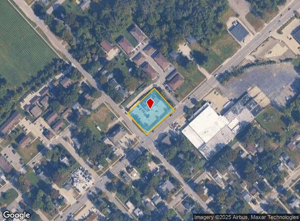
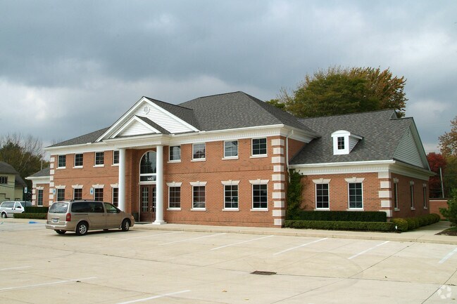
36821 Green St, New Baltimore, MI 48047


NEARBY LISTINGS FOR SALE OR LEASE
Property Detail
36821 Green St
06-09-13-278-014
Green
Medicalbuilding
T3N R14E SEC 13 COMM AT INTER OF NWLY SIDE LINE OF GREEN ST.& NELY SIDELINE OF ASHLEY ST; TH N40*48'W 170.0 FT ALG ASHLEY ST;
X
Macomb
26147C0490E
Michigan
2024
0.82 AC
2025
Macomb East
220003
Detroit
6,712 SF
Detroit-Warren-Dearborn, MI
DEMOGRAPHICS near 36821 Green St
1 Mile
3 Mile
5 Mile
2024 Total Population
6,424
28,035
61,312
2029 Population
6,311
27,947
61,259
Pop Growth 2024-2029
(1.76%)
(0.31%)
(0.09%)
Average Age
41
42
40
2024 Total Households
2,416
10,399
23,132
HH Growth 2024-2029
(1.66%)
(0.29%)
(0.05%)
Median Household Inc
$84,987
$88,517
$79,374
Avg Household Size
2.60
2.60
2.50
2024 Avg HH Vehicles
2.00
2.00
2.00
Median Home Value
$262,057
$270,800
$249,787
Median Year Built
1989
1993
1994
Nearby Places
Map Layers
Map Styles
 Street
 Aerial
- Restaurants
- Banks
- Shops
- Fitness
- Groceries
PUBLIC TRANSPORTATION
AIRPORT
Windsor International
DRIVE
WALK
Distance
Windsor International
71 min
45.2 mi
Nearby Properties
Address
Land Use
TOTAL SIZE
Lot Size
Zoning
Address
Land Use
TOTAL SIZE
Lot Size
Zoning
115,695 SF
Address
Land Use
TOTAL SIZE
Lot Size
Zoning
147,578 SF
12.84 AC
GC
Address
Land Use
TOTAL SIZE
Lot Size
Zoning
124,902 SF
11.38 AC
RM2 MU
Address
Land Use
TOTAL SIZE
Lot Size
Zoning
210,688 SF
20.13 AC
CG
Address
Land Use
TOTAL SIZE
Lot Size
Zoning
88,183 SF
27.97 AC
RM1 MU
Address
Land Use
TOTAL SIZE
Lot Size
Zoning
112,151 SF
9.31 AC
C3 GEN
Address
Land Use
TOTAL SIZE
Lot Size
Zoning
169,535 SF
12.20 AC
I
Address
Land Use
TOTAL SIZE
Lot Size
Zoning
7,262 SF
127.87 AC
MH
Address
Land Use
TOTAL SIZE
Lot Size
Zoning
276,497 SF
31.19 AC
I-1
Address
Land Use
TOTAL SIZE
Lot Size
Zoning
124,280 SF
11.50 AC
RM-1
Address
Land Use
TOTAL SIZE
Lot Size
Zoning
89,620 SF
17.89 AC
Address
Land Use
TOTAL SIZE
Lot Size
Zoning
7.70 AC
R1A RES
Address
Land Use
TOTAL SIZE
Lot Size
Zoning
60,123 SF
120 AC
I-2
Address
Land Use
TOTAL SIZE
Lot Size
Zoning
74,952 SF
6.05 AC
RM-2
Address
Land Use
TOTAL SIZE
Lot Size
Zoning
50,091 SF
4.80 AC
RM1 MU
Address
Land Use
TOTAL SIZE
Lot Size
Zoning
176,142 SF
21.95 AC
IND
Address
Land Use
TOTAL SIZE
Lot Size
Zoning
49,600 SF
14.50 AC
I-2
Address
Land Use
TOTAL SIZE
Lot Size
Zoning
22,140 SF
I
Address
Land Use
TOTAL SIZE
Lot Size
Zoning
30,240 SF
3.03 AC
GC
Address
Land Use
TOTAL SIZE
Lot Size
Zoning
15,788 SF
4.28 AC
CG
Address
Land Use
TOTAL SIZE
Lot Size
Zoning
8.66 AC
GC
Address
Land Use
TOTAL SIZE
Lot Size
Zoning
40,804 SF
3.53 AC
RM-1
Address
Land Use
TOTAL SIZE
Lot Size
Zoning
53,540 SF
7.99 AC
I
Address
Land Use
TOTAL SIZE
Lot Size
Zoning
21,944 SF
131.37 AC
CG
Address
Land Use
TOTAL SIZE
Lot Size
Zoning
7.93 AC
I-1
Address
Land Use
TOTAL SIZE
Lot Size
Zoning
80,600 SF
6.52 AC
I-2
Address
Land Use
TOTAL SIZE
Lot Size
Zoning
17,880 SF
4.78 AC
I
Address
Land Use
TOTAL SIZE
Lot Size
Zoning
56,505 SF
I-1
Address
Land Use
TOTAL SIZE
Lot Size
Zoning
48,639 SF
10.78 AC
C3 GEN
Address
Land Use
TOTAL SIZE
Lot Size
Zoning
27,314 SF
2.90 AC
C1 LOC
The World's #1 Commercial Real Estate Marketplace
Connect with us
© 2025 CoStar Group
The information above has been obtained from sources believed reliable. While we do not doubt its accuracy we have not verified it and make no guarantee, warranty or representation about it. It is your responsibility to independently confirm its accuracy and completeness. Any projections, opinions, assumptions, or estimates used are for example only and do not represent the current or future performance of the property. The value of this transaction to you depends on tax and other factors which should be evaluated by your tax, financial, and legal advisors. You and your advisors should conduct a careful, independent investigation of the property to determine to your satisfaction the suitability of the property for your needs.