Property Record
3685 W Outer Rd, Arnold, MO 63010
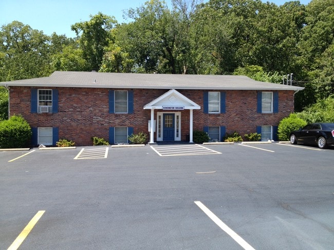

Property Detail
3685 W Outer Rd
09-3.0-06.0-1-002-005.01
US SURVEY 2991 PT LOT 5
Storebuilding
JEFFERSON
CT1
Missouri
AE The base floodplain where base flood elevations are provided. AE Zones are now used on new format FIRMs instead of A1-A30 Zones.
5
2024
0.50 AC
2025
Jefferson County
700117
St. Louis
3,944 SF
St. Louis, MO-IL
NEARBY LISTINGS FOR SALE OR LEASE
DEMOGRAPHICS near 3685 W Outer Rd
1 mile
3 mile
5 mile
2024 Total Population
9,230
45,365
89,412
2029 Population
9,227
45,727
89,726
Pop Growth 2024-2029
(0.03%)
+ 0.80%
+ 0.35%
Average Age
41
40
42
2024 Total Households
3,654
17,472
34,312
HH Growth 2024-2029
+ 0.03%
+ 0.82%
+ 0.37%
Median Household Inc
$87,786
$86,469
$95,508
Avg Household Size
2.50
2.60
2.60
2024 Avg HH Vehicles
2.00
2.00
2.00
Median Home Value
$242,938
$250,506
$274,826
Median Year Built
1987
1987
1986
Nearby Places
Map Layers
Map Styles
 Street
 Aerial
Transit
 Traffic
 Biking
Places
Listings with unknown addresses are not visible on the map
- Restaurants
- Banks
- Shops
- Fitness
- Groceries
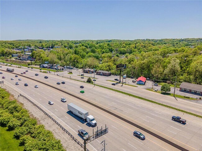
PUBLIC TRANSPORTATION
AIRPORT
St Louis Lambert International
Drive
Walk
Distance
St Louis Lambert International
44 min
28.7 mi
Freight Ports
Tulsa Port of Inola
Drive
Walk
Distance
Tulsa Port of Inola
420 min
378.8 mi
SALE & LEASE HISTORY
LISTING DATE
SALE/LEASE

Sep 08, 2017
For Lease
Nov 26, 2024
For Sale
Nov 26, 2024
For Lease
Jun 02, 2017
For Sale
Jan 11, 2024
For Lease
Dec 28, 2023
For Sale
Aug 29, 2020
For Lease
Nearby Properties
Address
Land Use
TOTAL SIZE
Lot Size
Zoning
Address
Land Use
TOTAL SIZE
Lot Size
Zoning
76,892 SF
Address
Land Use
TOTAL SIZE
Lot Size
Zoning
53,714 SF
59.99 AC
FPNU
Address
Land Use
TOTAL SIZE
Lot Size
Zoning
221,771 SF
25.15 AC
CT1
Address
Land Use
TOTAL SIZE
Lot Size
Zoning
315,332 SF
53.99 AC
CT1
Address
Land Use
TOTAL SIZE
Lot Size
Zoning
170,620 SF
8.62 AC
CT1
Address
Land Use
TOTAL SIZE
Lot Size
Zoning
83,024 SF
10.99 AC
CT1
Address
Land Use
TOTAL SIZE
Lot Size
Zoning
110,282 SF
5.16 AC
R07
Address
Land Use
TOTAL SIZE
Lot Size
Zoning
118,196 SF
13.33 AC
Address
Land Use
TOTAL SIZE
Lot Size
Zoning
13.03 AC
NU
Address
Land Use
TOTAL SIZE
Lot Size
Zoning
138,591 SF
5.46 AC
Address
Land Use
TOTAL SIZE
Lot Size
Zoning
127,189 SF
10.76 AC
Address
Land Use
TOTAL SIZE
Lot Size
Zoning
67,462 SF
8.18 AC
CT1
Address
Land Use
TOTAL SIZE
Lot Size
Zoning
184,685 SF
8.40 AC
Address
Land Use
TOTAL SIZE
Lot Size
Zoning
221,956 SF
14.53 AC
CT1
Address
Land Use
TOTAL SIZE
Lot Size
Zoning
116,965 SF
13 AC
Address
Land Use
TOTAL SIZE
Lot Size
Zoning
95,382 SF
1.88 AC
CT1
Address
Land Use
TOTAL SIZE
Lot Size
Zoning
75,733 SF
2.46 AC
Address
Land Use
TOTAL SIZE
Lot Size
Zoning
56,476 SF
2.14 AC
Address
Land Use
TOTAL SIZE
Lot Size
Zoning
87,466 SF
8.17 AC
Address
Land Use
TOTAL SIZE
Lot Size
Zoning
107,700 SF
7.81 AC
Address
Land Use
TOTAL SIZE
Lot Size
Zoning
139,500 SF
8.60 AC
CT1
Address
Land Use
TOTAL SIZE
Lot Size
Zoning
65,056 SF
10.18 AC
Address
Land Use
TOTAL SIZE
Lot Size
Zoning
372,506 SF
25.50 AC
PUD
Address
Land Use
TOTAL SIZE
Lot Size
Zoning
72,136 SF
13.73 AC
CT1
Address
Land Use
TOTAL SIZE
Lot Size
Zoning
15.10 AC
CC2
Address
Land Use
TOTAL SIZE
Lot Size
Zoning
152,346 SF
17.02 AC
CT1
Address
Land Use
TOTAL SIZE
Lot Size
Zoning
33,734 SF
5.61 AC
CC2
Address
Land Use
TOTAL SIZE
Lot Size
Zoning
41,898 SF
10.30 AC
Address
Land Use
TOTAL SIZE
Lot Size
Zoning
110,608 SF
12.17 AC
CT1
The World's #1 Commercial Real Estate Marketplace
Connect with us
© 2026 CoStar Group
The information above has been obtained from sources believed reliable. While we do not doubt its accuracy we have not verified it and make no guarantee, warranty or representation about it. It is your responsibility to independently confirm its accuracy and completeness. Any projections, opinions, assumptions, or estimates used are for example only and do not represent the current or future performance of the property. The value of this transaction to you depends on tax and other factors which should be evaluated by your tax, financial, and legal advisors. You and your advisors should conduct a careful, independent investigation of the property to determine to your satisfaction the suitability of the property for your needs.