Property Record
369 Beach Rd, Greenport, NY 11944
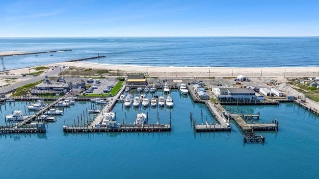
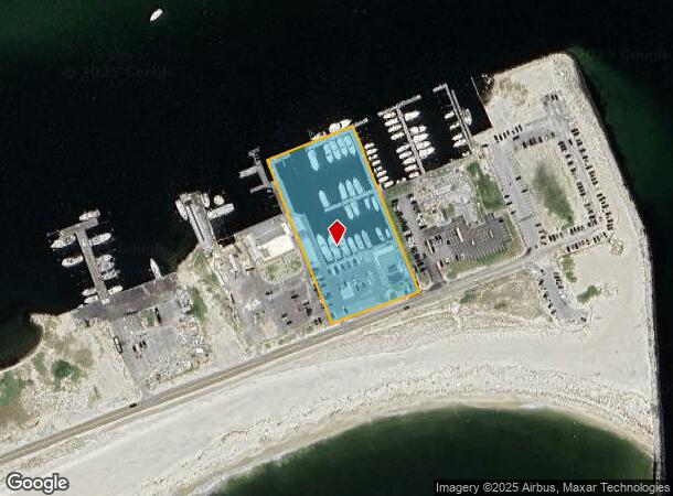
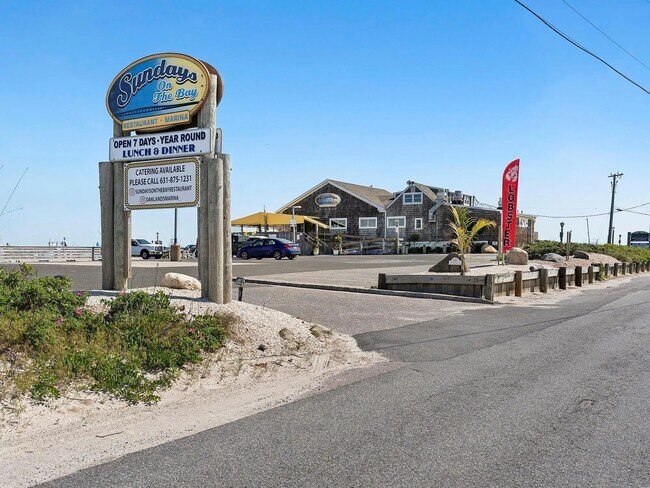
This Property Is For Sale
NEARBY LISTINGS FOR SALE OR LEASE
-
-
View all Greenport listings for sale on LoopNet.com
Property Detail
369 Beach Rd
0900-364-00-01-00-006-001
N-SHK. BAY E-SHK BAIT & TACK S-DUNE RD W-FISHERIES C & N
Marinafacility
Suffolk
AE
New York
36103C0803H
6
2024
2.73 AC
2024
Eastern Suffolk
170205
Long Island (New York)
5,419 SF
Nassau County-Suffolk County, NY
DEMOGRAPHICS near 369 Beach Rd
1 Mile
3 Mile
5 Mile
2024 Total Population
12
9,088
28,968
2029 Population
13
9,432
30,107
Pop Growth 2024-2029
+ 8.33%
+ 3.79%
+ 3.93%
Average Age
47
42
43
2024 Total Households
5
3,391
10,874
HH Growth 2024-2029
0.00%
+ 3.86%
+ 3.93%
Median Household Inc
$199,999
$130,662
$116,857
Avg Household Size
2.50
2.60
2.60
2024 Avg HH Vehicles
2.00
2.00
2.00
Median Home Value
$1,112,500
$736,168
$780,102
Median Year Built
1989
1973
1976
Nearby Places
Map Layers
Map Styles
 Street
 Aerial
- Restaurants
- Banks
- Shops
- Fitness
- Groceries
PUBLIC TRANSPORTATION
COMMUTER RAIL
Hampton Bays Station (Montauk Branch - Long Island Rail Road)
DRIVE
WALK
Distance
Hampton Bays Station (Montauk Branch - Long Island Rail Road)
8 min
4.3 mi
Freight Ports
Port of New Haven
DRIVE
WALK
Distance
Port of New Haven
169 min
72.9 mi
Nearby Properties
Address
Land Use
TOTAL SIZE
Lot Size
Zoning
Address
Land Use
TOTAL SIZE
Lot Size
Zoning
30.90 AC
VILLA
Address
Land Use
TOTAL SIZE
Lot Size
Zoning
8,309 SF
4.50 AC
VILLA
Address
Land Use
TOTAL SIZE
Lot Size
Zoning
16,677 SF
25.40 AC
R20
Address
Land Use
TOTAL SIZE
Lot Size
Zoning
47,996 SF
19.50 AC
R20
Address
Land Use
TOTAL SIZE
Lot Size
Zoning
2.75 AC
VILLA
Address
Land Use
TOTAL SIZE
Lot Size
Zoning
3,784 SF
2.40 AC
VILLA
Address
Land Use
TOTAL SIZE
Lot Size
Zoning
2.72 AC
VILLA
Address
Land Use
TOTAL SIZE
Lot Size
Zoning
2.76 AC
VILLA
Address
Land Use
TOTAL SIZE
Lot Size
Zoning
1.67 AC
VILLA
Address
Land Use
TOTAL SIZE
Lot Size
Zoning
6.55 AC
VILLA
Address
Land Use
TOTAL SIZE
Lot Size
Zoning
10,152 SF
0.80 AC
R15
Address
Land Use
TOTAL SIZE
Lot Size
Zoning
5.18 AC
VILLA
Address
Land Use
TOTAL SIZE
Lot Size
Zoning
3.05 AC
VILLA
Address
Land Use
TOTAL SIZE
Lot Size
Zoning
5.90 AC
VILLA
Address
Land Use
TOTAL SIZE
Lot Size
Zoning
16,249 SF
7.40 AC
R40
Address
Land Use
TOTAL SIZE
Lot Size
Zoning
6.60 AC
VILLA
Address
Land Use
TOTAL SIZE
Lot Size
Zoning
3.30 AC
VILLA
Address
Land Use
TOTAL SIZE
Lot Size
Zoning
3.20 AC
VILLA
Address
Land Use
TOTAL SIZE
Lot Size
Zoning
3.10 AC
VILLA
Address
Land Use
TOTAL SIZE
Lot Size
Zoning
13,448 SF
2.12 AC
R60
Address
Land Use
TOTAL SIZE
Lot Size
Zoning
1.67 AC
VILLA
Address
Land Use
TOTAL SIZE
Lot Size
Zoning
2.90 AC
VILLA
Address
Land Use
TOTAL SIZE
Lot Size
Zoning
1.61 AC
VILLA
Address
Land Use
TOTAL SIZE
Lot Size
Zoning
1.80 AC
VILLA
Address
Land Use
TOTAL SIZE
Lot Size
Zoning
1.40 AC
VILLA
Address
Land Use
TOTAL SIZE
Lot Size
Zoning
0.98 AC
VILLA
Address
Land Use
TOTAL SIZE
Lot Size
Zoning
19,542 SF
3.56 AC
R40
Address
Land Use
TOTAL SIZE
Lot Size
Zoning
11,520 SF
4.80 AC
RWB
Address
Land Use
TOTAL SIZE
Lot Size
Zoning
56.50 AC
OSC
Address
Land Use
TOTAL SIZE
Lot Size
Zoning
19,399 SF
9.40 AC
R40
The World's #1 Commercial Real Estate Marketplace
Connect with us
© 2026 CoStar Group
The information above has been obtained from sources believed reliable. While we do not doubt its accuracy we have not verified it and make no guarantee, warranty or representation about it. It is your responsibility to independently confirm its accuracy and completeness. Any projections, opinions, assumptions, or estimates used are for example only and do not represent the current or future performance of the property. The value of this transaction to you depends on tax and other factors which should be evaluated by your tax, financial, and legal advisors. You and your advisors should conduct a careful, independent investigation of the property to determine to your satisfaction the suitability of the property for your needs.