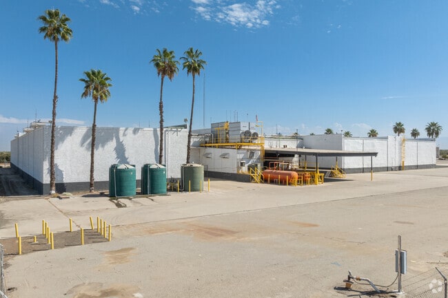
Property Record
369 Road 176, Delano, CA 93215


Save to a Folder
{{folder.Name}}
{{folder.ListingIds.length}} Properties
{{folder.ListingIds.length}} Property
Create a New Folder
Current Lease Availabilities
Property Detail
369 Road 176
338-270-019-000
POR SE/4 SEC 32-24-26
Packing
TULARE
A-1
California
B and X Area of moderate flood hazard, usually the area between the limits of the 100-year and 500-year floods.
15.66 AC
2024
SW Outlying Tulare County
2025
Visalia/Porterville
004301
Visalia, CA
133,332 SF
NEARBY LISTINGS FOR SALE OR LEASE
-
-
View all Delano listings for lease on LoopNet.com
DEMOGRAPHICS near 369 Road 176
1 mile
3 mile
5 mile
2025 Total Population
80
7,857
38,983
2030 Population
79
7,844
39,153
Pop Growth 2025-2030
(1.25%)
(0.17%)
+ 0.44%
Average Age
35
36
35
2025 Total Households
20
1,904
9,993
HH Growth 2025-2030
(5.00%)
(0.32%)
+ 0.50%
Median Household Inc
$42,916
$86,924
$63,816
Avg Household Size
4.20
4.00
3.80
2025 Avg HH Vehicles
2.00
3.00
2.00
Median Home Value
$366,666
$364,786
$312,065
Median Year Built
1974
1991
1984
Nearby Places
Map Layers
Map Styles
 Street
 Aerial
Layers
 Traffic
 Biking
Places
Listings with unknown addresses are not visible on the map
- Restaurants
- Banks
- Shops
- Fitness
- Groceries
PUBLIC TRANSPORTATION
AIRPORT
Meadows Field
Drive
Walk
Distance
Meadows Field
50 min
34.0 mi
Freight Ports
The Port of Hueneme
Drive
Walk
Distance
The Port of Hueneme
198 min
158.7 mi
Nearby Properties
Address
Land Use
TOTAL SIZE
Lot Size
Zoning
Address
Land Use
TOTAL SIZE
Lot Size
Zoning
115,071 SF
46.83 AC
R-1
Address
Land Use
TOTAL SIZE
Lot Size
Zoning
75.80 AC
A
Address
Land Use
TOTAL SIZE
Lot Size
Zoning
1,891 SF
20.03 AC
A
Address
Land Use
TOTAL SIZE
Lot Size
Zoning
6,969 SF
9.96 AC
A
Address
Land Use
TOTAL SIZE
Lot Size
Zoning
138,808 SF
18.84 AC
AE20
Address
Land Use
TOTAL SIZE
Lot Size
Zoning
18,538 SF
7.25 AC
R-1
Address
Land Use
TOTAL SIZE
Lot Size
Zoning
32.90 AC
AE20
Address
Land Use
TOTAL SIZE
Lot Size
Zoning
3,098 SF
0.81 AC
GC
Address
Land Use
TOTAL SIZE
Lot Size
Zoning
6,029 SF
310.81 AC
A
Address
Land Use
TOTAL SIZE
Lot Size
Zoning
134.34 AC
A
Address
Land Use
TOTAL SIZE
Lot Size
Zoning
8,000 SF
0.94 AC
GC
Address
Land Use
TOTAL SIZE
Lot Size
Zoning
75.66 AC
A
Address
Land Use
TOTAL SIZE
Lot Size
Zoning
9.13 AC
AE20
Address
Land Use
TOTAL SIZE
Lot Size
Zoning
7,394 SF
1 AC
GC
Address
Land Use
TOTAL SIZE
Lot Size
Zoning
7,200 SF
18.86 AC
M1-SR
Address
Land Use
TOTAL SIZE
Lot Size
Zoning
161.80 AC
A
Address
Land Use
TOTAL SIZE
Lot Size
Zoning
160.50 AC
AE20
Address
Land Use
TOTAL SIZE
Lot Size
Zoning
1,250 SF
3.74 AC
Address
Land Use
TOTAL SIZE
Lot Size
Zoning
9.04 AC
A
Address
Land Use
TOTAL SIZE
Lot Size
Zoning
13.92 AC
AE20
Address
Land Use
TOTAL SIZE
Lot Size
Zoning
74.37 AC
Address
Land Use
TOTAL SIZE
Lot Size
Zoning
10 AC
M1
Address
Land Use
TOTAL SIZE
Lot Size
Zoning
18.84 AC
A
Address
Land Use
TOTAL SIZE
Lot Size
Zoning
138.19 AC
A
Address
Land Use
TOTAL SIZE
Lot Size
Zoning
77.27 AC
A
Address
Land Use
TOTAL SIZE
Lot Size
Zoning
154.84 AC
Address
Land Use
TOTAL SIZE
Lot Size
Zoning
5.75 AC
AE20
Address
Land Use
TOTAL SIZE
Lot Size
Zoning
1,092 SF
19.54 AC
A
The World's #1 Commercial Real Estate Marketplace
Connect with us
© 2026 CoStar Group
The information above has been obtained from sources believed reliable. While we do not doubt its accuracy we have not verified it and make no guarantee, warranty or representation about it. It is your responsibility to independently confirm its accuracy and completeness. Any projections, opinions, assumptions, or estimates used are for example only and do not represent the current or future performance of the property. The value of this transaction to you depends on tax and other factors which should be evaluated by your tax, financial, and legal advisors. You and your advisors should conduct a careful, independent investigation of the property to determine to your satisfaction the suitability of the property for your needs.