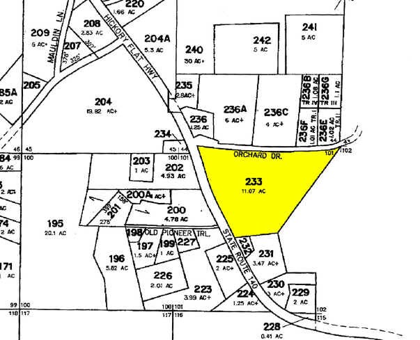
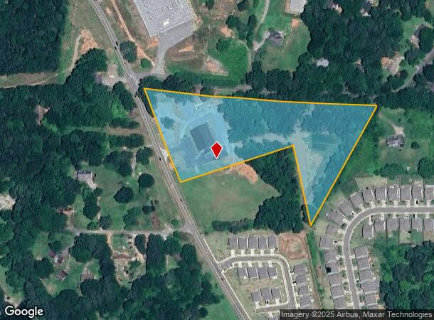
Property Record
3693 Hickory Flat Hwy, Canton, GA 30115

NEARBY LISTINGS FOR SALE OR LEASE
Property Detail
3693 Hickory Flat Hwy
015N19-00000-233-000-0000
Margaret V Sapp
Religious
LL 101; 15TH D/TRACT 2
X
Cherokee
13057C0254E
Georgia
0
6.89 AC
2025
Cherokee County
090603
Atlanta
7,800 SF
Atlanta-Sandy Springs-Roswell, GA
DEMOGRAPHICS near 3693 Hickory Flat Hwy
1 Mile
3 Mile
5 Mile
2024 Total Population
4,616
32,008
88,630
2029 Population
5,267
36,721
101,461
Pop Growth 2024-2029
+ 14.10%
+ 14.72%
+ 14.48%
Average Age
38
39
38
2024 Total Households
1,442
10,712
30,713
HH Growth 2024-2029
+ 14.29%
+ 14.87%
+ 14.65%
Median Household Inc
$130,177
$106,384
$94,913
Avg Household Size
3.00
2.90
2.80
2024 Avg HH Vehicles
2.00
2.00
2.00
Median Home Value
$363,535
$376,786
$362,157
Median Year Built
2003
2002
2001
Nearby Places
Map Layers
Map Styles
 Street
 Aerial
- Restaurants
- Banks
- Shops
- Fitness
- Groceries
SALE & LEASE HISTORY
LISTING DATE
SALE/LEASE

Jan 05, 2017
For Sale
Nearby Properties
Address
Land Use
TOTAL SIZE
Lot Size
Zoning
Address
Land Use
TOTAL SIZE
Lot Size
Zoning
242,502 SF
41.65 AC
PD
Address
Land Use
TOTAL SIZE
Lot Size
Zoning
611,396 SF
93.78 AC
R-40
Address
Land Use
TOTAL SIZE
Lot Size
Zoning
255,483 SF
138.30 AC
LI
Address
Land Use
TOTAL SIZE
Lot Size
Zoning
353,395 SF
29.15 AC
GC
Address
Land Use
TOTAL SIZE
Lot Size
Zoning
162,243 SF
29.44 AC
R-5
Address
Land Use
TOTAL SIZE
Lot Size
Zoning
313,906 SF
28.96 AC
PD
Address
Land Use
TOTAL SIZE
Lot Size
Zoning
204,826 SF
4.91 AC
PD
Address
Land Use
TOTAL SIZE
Lot Size
Zoning
24,586 SF
PD
Address
Land Use
TOTAL SIZE
Lot Size
Zoning
149,713 SF
36.97 AC
R-80
Address
Land Use
TOTAL SIZE
Lot Size
Zoning
191,105 SF
12.37 AC
PD
Address
Land Use
TOTAL SIZE
Lot Size
Zoning
134,017 SF
42.78 AC
AG
Address
Land Use
TOTAL SIZE
Lot Size
Zoning
151,121 SF
33.37 AC
GC
Address
Land Use
TOTAL SIZE
Lot Size
Zoning
123,941 SF
18.41 AC
GC
Address
Land Use
TOTAL SIZE
Lot Size
Zoning
139,274 SF
12.34 AC
PD
Address
Land Use
TOTAL SIZE
Lot Size
Zoning
107.28 AC
PD
Address
Land Use
TOTAL SIZE
Lot Size
Zoning
81,237 SF
11.63 AC
R-5
Address
Land Use
TOTAL SIZE
Lot Size
Zoning
35,443 SF
OI
Address
Land Use
TOTAL SIZE
Lot Size
Zoning
58.97 AC
OI
Address
Land Use
TOTAL SIZE
Lot Size
Zoning
54.76 AC
PD
Address
Land Use
TOTAL SIZE
Lot Size
Zoning
69,360 SF
5.86 AC
R-80
Address
Land Use
TOTAL SIZE
Lot Size
Zoning
60,882 SF
12.94 AC
GC
Address
Land Use
TOTAL SIZE
Lot Size
Zoning
86,913 SF
6.47 AC
PD
Address
Land Use
TOTAL SIZE
Lot Size
Zoning
30,996 SF
2.05 AC
PDR
Address
Land Use
TOTAL SIZE
Lot Size
Zoning
35,360 SF
OI
Address
Land Use
TOTAL SIZE
Lot Size
Zoning
158,853 SF
33.73 AC
LI
Address
Land Use
TOTAL SIZE
Lot Size
Zoning
55,778 SF
5.28 AC
GC
Address
Land Use
TOTAL SIZE
Lot Size
Zoning
24,158 SF
2.59 AC
NC
Address
Land Use
TOTAL SIZE
Lot Size
Zoning
52,895 SF
4.02 AC
GC
Address
Land Use
TOTAL SIZE
Lot Size
Zoning
1,428 SF
43.56 AC
R-80
Address
Land Use
TOTAL SIZE
Lot Size
Zoning
51,148 SF
18.98 AC
R-40
The World's #1 Commercial Real Estate Marketplace
Connect with us
© 2025 CoStar Group
The information above has been obtained from sources believed reliable. While we do not doubt its accuracy we have not verified it and make no guarantee, warranty or representation about it. It is your responsibility to independently confirm its accuracy and completeness. Any projections, opinions, assumptions, or estimates used are for example only and do not represent the current or future performance of the property. The value of this transaction to you depends on tax and other factors which should be evaluated by your tax, financial, and legal advisors. You and your advisors should conduct a careful, independent investigation of the property to determine to your satisfaction the suitability of the property for your needs.