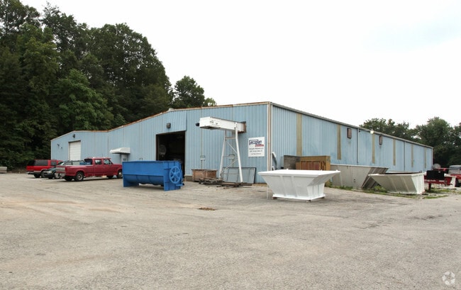
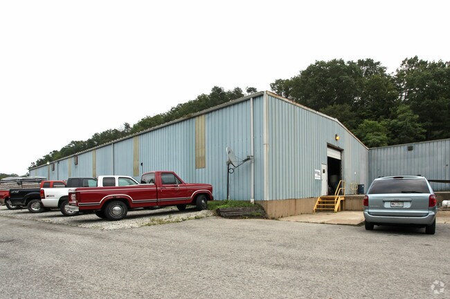
Property Record
3693 Paoli Pike, Floyds Knobs, IN 47119

Property Detail
3693 Paoli Pike
Louisville/Jefferson County, KY-IN
NE 1/4 SW 1/4 20-2-6 14.233 A. PRT LOT 6 20-2-6 3721 PAOLI PIKE (22-04-02-000-360.000-006)
22-04-02-000-143.000-006
Floyd
Manufacturinglight
Indiana
AE The base floodplain where base flood elevations are provided. AE Zones are now used on new format FIRMs instead of A1-A30 Zones.
6
2025
14.23 AC
2025
Outlying Floyd County
071103
Louisville
20,050 SF
NEARBY LISTINGS FOR SALE OR LEASE
-
-
View all Floyds Knobs listings for sale on LoopNet.com
DEMOGRAPHICS near 3693 Paoli Pike
1 mile
3 mile
5 mile
2025 Total Population
2,024
20,127
68,818
2030 Population
2,044
20,425
70,396
Pop Growth 2025-2030
+ 0.99%
+ 1.48%
+ 2.29%
Average Age
43
41
41
2025 Total Households
742
8,046
28,180
HH Growth 2025-2030
+ 0.94%
+ 1.43%
+ 2.31%
Median Household Inc
$128,991
$81,864
$73,587
Avg Household Size
2.70
2.40
2.30
2025 Avg HH Vehicles
3.00
2.00
2.00
Median Home Value
$455,985
$265,821
$240,687
Median Year Built
1986
1976
1971
Nearby Places
Map Layers
Map Styles
 Street
 Aerial
Layers
 Traffic
 Biking
Places
Listings with unknown addresses are not visible on the map
- Restaurants
- Banks
- Shops
- Fitness
- Groceries
PUBLIC TRANSPORTATION
AIRPORT
Louisville Muhammad Ali International
Drive
Walk
Distance
Louisville Muhammad Ali International
31 min
18.8 mi
Nearby Properties
Address
Land Use
TOTAL SIZE
Lot Size
Zoning
Address
Land Use
TOTAL SIZE
Lot Size
Zoning
175,626 SF
60.10 AC
Address
Land Use
TOTAL SIZE
Lot Size
Zoning
12,270 SF
13.50 AC
Address
Land Use
TOTAL SIZE
Lot Size
Zoning
25,728 SF
10.37 AC
Address
Land Use
TOTAL SIZE
Lot Size
Zoning
4,512 SF
17.76 AC
Address
Land Use
TOTAL SIZE
Lot Size
Zoning
21,692 SF
30.54 AC
Address
Land Use
TOTAL SIZE
Lot Size
Zoning
39,851 SF
19.68 AC
Address
Land Use
TOTAL SIZE
Lot Size
Zoning
169 SF
35.25 AC
Address
Land Use
TOTAL SIZE
Lot Size
Zoning
34,308 SF
4.59 AC
Address
Land Use
TOTAL SIZE
Lot Size
Zoning
72,332 SF
2.48 AC
Address
Land Use
TOTAL SIZE
Lot Size
Zoning
1.84 AC
Address
Land Use
TOTAL SIZE
Lot Size
Zoning
83,084 SF
14.65 AC
Address
Land Use
TOTAL SIZE
Lot Size
Zoning
31,646 SF
5.63 AC
Address
Land Use
TOTAL SIZE
Lot Size
Zoning
35,044 SF
3.39 AC
Address
Land Use
TOTAL SIZE
Lot Size
Zoning
118,371 SF
11.83 AC
Address
Land Use
TOTAL SIZE
Lot Size
Zoning
26,532 SF
4.35 AC
Address
Land Use
TOTAL SIZE
Lot Size
Zoning
56,547 SF
5.65 AC
Address
Land Use
TOTAL SIZE
Lot Size
Zoning
3,360 SF
9.40 AC
Address
Land Use
TOTAL SIZE
Lot Size
Zoning
125,751 SF
22.59 AC
Address
Land Use
TOTAL SIZE
Lot Size
Zoning
7,496 SF
9.37 AC
Address
Land Use
TOTAL SIZE
Lot Size
Zoning
65,748 SF
4.34 AC
Address
Land Use
TOTAL SIZE
Lot Size
Zoning
42,344 SF
6.77 AC
Address
Land Use
TOTAL SIZE
Lot Size
Zoning
59,998 SF
7.28 AC
Address
Land Use
TOTAL SIZE
Lot Size
Zoning
185,587 SF
4.30 AC
Address
Land Use
TOTAL SIZE
Lot Size
Zoning
131,952 SF
4.32 AC
Address
Land Use
TOTAL SIZE
Lot Size
Zoning
396,757 SF
6.59 AC
Address
Land Use
TOTAL SIZE
Lot Size
Zoning
21,780 SF
11.44 AC
Address
Land Use
TOTAL SIZE
Lot Size
Zoning
26,780 SF
0.72 AC
Address
Land Use
TOTAL SIZE
Lot Size
Zoning
9,124 SF
2.08 AC
Address
Land Use
TOTAL SIZE
Lot Size
Zoning
42,520 SF
7.25 AC
Address
Land Use
TOTAL SIZE
Lot Size
Zoning
85,016 SF
3.49 AC
The World's #1 Commercial Real Estate Marketplace
Connect with us
© 2026 CoStar Group
The information above has been obtained from sources believed reliable. While we do not doubt its accuracy we have not verified it and make no guarantee, warranty or representation about it. It is your responsibility to independently confirm its accuracy and completeness. Any projections, opinions, assumptions, or estimates used are for example only and do not represent the current or future performance of the property. The value of this transaction to you depends on tax and other factors which should be evaluated by your tax, financial, and legal advisors. You and your advisors should conduct a careful, independent investigation of the property to determine to your satisfaction the suitability of the property for your needs.