Property Record
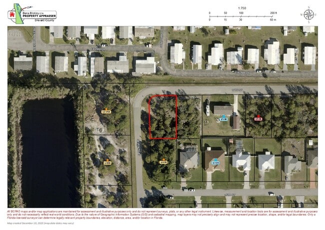
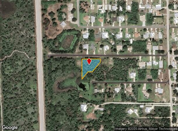
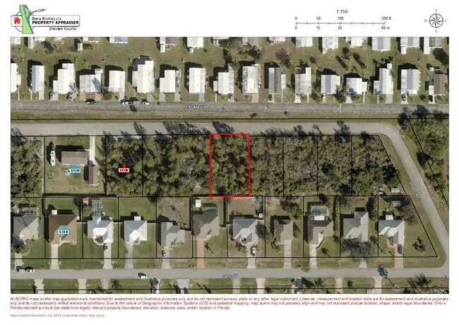
3705 11Th St, Sebastian, FL 32976
NEARBY LISTINGS FOR SALE OR LEASE
Property Detail
3705 11Th St
Palm Bay-Melbourne-Titusville, FL
San Sebastian Plat No 1
30-38-23-HH-00024.0-0000.00
SAN SEBASTIAN PLAT NO 1 ALL BLK 24 & PT OF VAC DAYTONA BLVD KNOWN AS PARCEL #214 IN ORB 5515 PG 519 DESC AS: COMMENCE @ INTERSECT OF SEVENTH AVE & TENTH ST; S89E 35.65; N00E 59.42 TO POB THENCE N00E 239.59; S89E 220.79; S00W 35.79; S40.4419W 75; S40.
Recreationalacreage
Brevard
A
Florida
12061C0085J
4
2024
0.72 AC
2025
Brevard County
065239
Orlando
DEMOGRAPHICS near 3705 11Th St
1 Mile
3 Mile
5 Mile
2024 Total Population
1,742
13,376
23,447
2029 Population
1,919
14,898
26,103
Pop Growth 2024-2029
+ 10.16%
+ 11.38%
+ 11.33%
Average Age
61
62
58
2024 Total Households
951
7,326
12,051
HH Growth 2024-2029
+ 9.99%
+ 11.07%
+ 10.95%
Median Household Inc
$42,033
$45,658
$52,660
Avg Household Size
1.80
1.80
1.90
2024 Avg HH Vehicles
1.00
2.00
2.00
Median Home Value
$178,684
$182,220
$240,421
Median Year Built
1985
1985
1987
Nearby Places
Map Layers
Map Styles
 Street
 Aerial
- Restaurants
- Banks
- Shops
- Fitness
- Groceries
PUBLIC TRANSPORTATION
AIRPORT
Melbourne Orlando International
DRIVE
WALK
Distance
Melbourne Orlando International
36 min
20.4 mi
Freight Ports
Port Canaveral
DRIVE
WALK
Distance
Port Canaveral
74 min
56.8 mi
SALE & LEASE HISTORY
LISTING DATE
SALE/LEASE

Jan 02, 2024
For Sale
Nearby Properties
Address
Land Use
TOTAL SIZE
Lot Size
Zoning
Address
Land Use
TOTAL SIZE
Lot Size
Zoning
1,216 SF
17.75 AC
MED
Address
Land Use
TOTAL SIZE
Lot Size
Zoning
2,766 SF
56.02 AC
GU
Address
Land Use
TOTAL SIZE
Lot Size
Zoning
182,069 SF
23.50 AC
CR
Address
Land Use
TOTAL SIZE
Lot Size
Zoning
5,836 SF
35.46 AC
RS-1
Address
Land Use
TOTAL SIZE
Lot Size
Zoning
64,620 SF
3.15 AC
CR
Address
Land Use
TOTAL SIZE
Lot Size
Zoning
264 SF
11.13 AC
CG
Address
Land Use
TOTAL SIZE
Lot Size
Zoning
19.92 AC
GU
Address
Land Use
TOTAL SIZE
Lot Size
Zoning
123,774 SF
13.82 AC
CG
Address
Land Use
TOTAL SIZE
Lot Size
Zoning
5,914 SF
14.77 AC
PS
Address
Land Use
TOTAL SIZE
Lot Size
Zoning
36,160 SF
4.58 AC
CR
Address
Land Use
TOTAL SIZE
Lot Size
Zoning
320.14 AC
GU
Address
Land Use
TOTAL SIZE
Lot Size
Zoning
55,281 SF
8.54 AC
BU1
Address
Land Use
TOTAL SIZE
Lot Size
Zoning
1,600 SF
12.10 AC
GML(H)
Address
Land Use
TOTAL SIZE
Lot Size
Zoning
59,976 SF
5.34 AC
BU2
Address
Land Use
TOTAL SIZE
Lot Size
Zoning
70,734 SF
7.24 AC
CG
Address
Land Use
TOTAL SIZE
Lot Size
Zoning
852 SF
285.85 AC
AU
Address
Land Use
TOTAL SIZE
Lot Size
Zoning
28,025 SF
19 AC
INL
Address
Land Use
TOTAL SIZE
Lot Size
Zoning
6,936 SF
2.82 AC
CR
Address
Land Use
TOTAL SIZE
Lot Size
Zoning
134.40 AC
IN
Address
Land Use
TOTAL SIZE
Lot Size
Zoning
44,918 SF
2.83 AC
BU2
Address
Land Use
TOTAL SIZE
Lot Size
Zoning
272 SF
0.92 AC
GML-H
Address
Land Use
TOTAL SIZE
Lot Size
Zoning
2.33 AC
GML(P)
Address
Land Use
TOTAL SIZE
Lot Size
Zoning
27 AC
Address
Land Use
TOTAL SIZE
Lot Size
Zoning
14,615 SF
2.26 AC
CL
Address
Land Use
TOTAL SIZE
Lot Size
Zoning
13,940 SF
15.70 AC
CR
Address
Land Use
TOTAL SIZE
Lot Size
Zoning
19,800 SF
2.35 AC
CR
Address
Land Use
TOTAL SIZE
Lot Size
Zoning
0.73 AC
GML(P)
Address
Land Use
TOTAL SIZE
Lot Size
Zoning
16,612 SF
10.38 AC
GML
Address
Land Use
TOTAL SIZE
Lot Size
Zoning
15.85 AC
CG
Address
Land Use
TOTAL SIZE
Lot Size
Zoning
3,152 SF
0.85 AC
RU24
The World's #1 Commercial Real Estate Marketplace
Connect with us
© 2025 CoStar Group
The information above has been obtained from sources believed reliable. While we do not doubt its accuracy we have not verified it and make no guarantee, warranty or representation about it. It is your responsibility to independently confirm its accuracy and completeness. Any projections, opinions, assumptions, or estimates used are for example only and do not represent the current or future performance of the property. The value of this transaction to you depends on tax and other factors which should be evaluated by your tax, financial, and legal advisors. You and your advisors should conduct a careful, independent investigation of the property to determine to your satisfaction the suitability of the property for your needs.