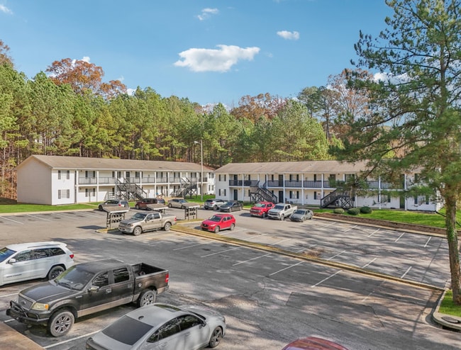
Property Record
36Th Ave E, Tuscaloosa, AL 35405

Save to a Folder
{{folder.Name}}
{{folder.ListingIds.length}} Properties
{{folder.ListingIds.length}} Property
Create a New Folder
Property Detail
36Th Ave E
37-03-05-4-001-003.021
PARCEL 19 OF TREE TOP APARTMENTS INC LESS RD R/W
Apartment
TUSCALOOSA
R4
Alabama
AE The base floodplain where base flood elevations are provided. AE Zones are now used on new format FIRMs instead of A1-A30 Zones.
0.51 AC
2025
Skyland-McFarland
2025
Birmingham
010500
Tuscaloosa, AL
5,236 SF
NEARBY LISTINGS FOR SALE OR LEASE
DEMOGRAPHICS near 36Th Ave E
1 mile
3 mile
5 mile
2025 Total Population
4,988
33,635
95,884
2030 Population
4,993
33,718
97,555
Pop Growth 2025-2030
+ 0.10%
+ 0.25%
+ 1.74%
Average Age
36
38
35
2025 Total Households
2,305
14,871
38,780
HH Growth 2025-2030
+ 0.26%
+ 0.15%
+ 1.79%
Median Household Inc
$53,923
$56,211
$47,156
Avg Household Size
2.10
2.20
2.20
2025 Avg HH Vehicles
2.00
2.00
2.00
Median Home Value
$221,717
$219,410
$221,484
Median Year Built
1990
1989
1993
Nearby Places
Map Layers
Map Styles
 Street
 Aerial
Layers
 Traffic
 Biking
Places
Listings with unknown addresses are not visible on the map
- Restaurants
- Banks
- Shops
- Fitness
- Groceries
PUBLIC TRANSPORTATION
COMMUTER RAIL
Tuscaloosa Amtrak Station (Crescent - Amtrak)
Drive
Walk
Distance
Tuscaloosa Amtrak Station (Crescent - Amtrak)
11 min
5.6 mi
Freight Ports
Port of Mobile
Drive
Walk
Distance
Port of Mobile
243 min
202.1 mi
Nearby Properties
Address
Land Use
TOTAL SIZE
Lot Size
Zoning
Address
Land Use
TOTAL SIZE
Lot Size
Zoning
8,760 SF
23 AC
R4
Address
Land Use
TOTAL SIZE
Lot Size
Zoning
5,377 SF
22 AC
RMF1
Address
Land Use
TOTAL SIZE
Lot Size
Zoning
9,328 SF
19 AC
RMF1
Address
Land Use
TOTAL SIZE
Lot Size
Zoning
1,088 SF
17 AC
R4
Address
Land Use
TOTAL SIZE
Lot Size
Zoning
5,568 SF
50 AC
Address
Land Use
TOTAL SIZE
Lot Size
Zoning
25,155 SF
6 AC
R4
Address
Land Use
TOTAL SIZE
Lot Size
Zoning
15,912 SF
22 AC
Address
Land Use
TOTAL SIZE
Lot Size
Zoning
32,616 SF
11 AC
Address
Land Use
TOTAL SIZE
Lot Size
Zoning
9,796 SF
14 AC
RMF1
Address
Land Use
TOTAL SIZE
Lot Size
Zoning
16,536 SF
15.96 AC
R4
Address
Land Use
TOTAL SIZE
Lot Size
Zoning
2,442 SF
10.85 AC
R4
Address
Land Use
TOTAL SIZE
Lot Size
Zoning
13,110 SF
7.33 AC
RMF1
Address
Land Use
TOTAL SIZE
Lot Size
Zoning
193,154 SF
20 AC
BN
Address
Land Use
TOTAL SIZE
Lot Size
Zoning
7,536 SF
11 AC
R4
Address
Land Use
TOTAL SIZE
Lot Size
Zoning
20,535 SF
5.50 AC
R4
Address
Land Use
TOTAL SIZE
Lot Size
Zoning
4,620 SF
12.55 AC
R4
Address
Land Use
TOTAL SIZE
Lot Size
Zoning
1,816 SF
5.30 AC
Address
Land Use
TOTAL SIZE
Lot Size
Zoning
8,000 SF
8.30 AC
R4
Address
Land Use
TOTAL SIZE
Lot Size
Zoning
8,454 SF
5.30 AC
BH
Address
Land Use
TOTAL SIZE
Lot Size
Zoning
22,672 SF
13 AC
R4
Address
Land Use
TOTAL SIZE
Lot Size
Zoning
56,211 SF
2.05 AC
BH
Address
Land Use
TOTAL SIZE
Lot Size
Zoning
174,624 SF
9.90 AC
BN
Address
Land Use
TOTAL SIZE
Lot Size
Zoning
6,992 SF
13 AC
RMF1
Address
Land Use
TOTAL SIZE
Lot Size
Zoning
66,949 SF
3.60 AC
BH
Address
Land Use
TOTAL SIZE
Lot Size
Zoning
42,408 SF
5.50 AC
R4
Address
Land Use
TOTAL SIZE
Lot Size
Zoning
206,739 SF
22.69 AC
BN
Address
Land Use
TOTAL SIZE
Lot Size
Zoning
5,016 SF
9.30 AC
BN
Address
Land Use
TOTAL SIZE
Lot Size
Zoning
59,082 SF
4.13 AC
R1
Address
Land Use
TOTAL SIZE
Lot Size
Zoning
58,008 SF
1.77 AC
BH
Address
Land Use
TOTAL SIZE
Lot Size
Zoning
41,250 SF
2.22 AC
BH
The World's #1 Commercial Real Estate Marketplace
Connect with us
© 2026 CoStar Group
The information above has been obtained from sources believed reliable. While we do not doubt its accuracy we have not verified it and make no guarantee, warranty or representation about it. It is your responsibility to independently confirm its accuracy and completeness. Any projections, opinions, assumptions, or estimates used are for example only and do not represent the current or future performance of the property. The value of this transaction to you depends on tax and other factors which should be evaluated by your tax, financial, and legal advisors. You and your advisors should conduct a careful, independent investigation of the property to determine to your satisfaction the suitability of the property for your needs.