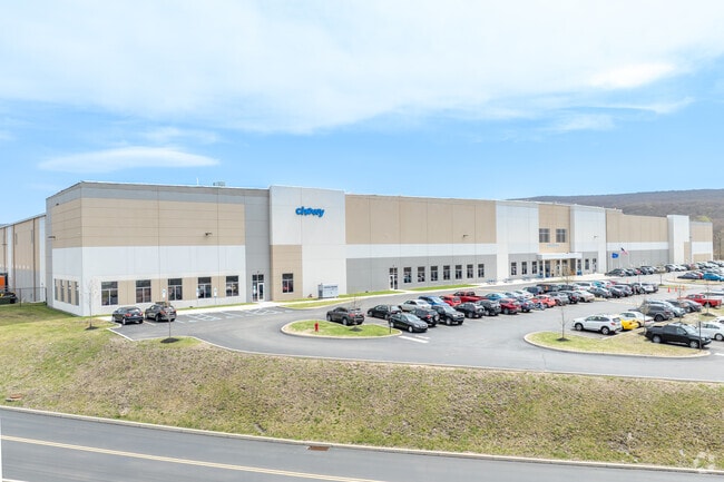
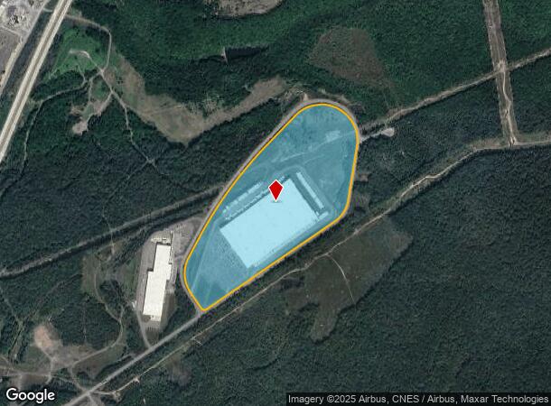
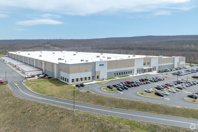
Property Record
37 Archbald Heights Dr, Archbald, PA 18403
NEARBY LISTINGS FOR SALE OR LEASE
Property Detail
37 Archbald Heights Dr
Scranton--Wilkes-Barre, PA
Valley View Bus Par
1050401000137
70.21A VALLEY VIEW BUS PARK PH II L37A
Distributionwarehouseregional
Lackawanna
X
Pennsylvania
42069C0231D
37a
2025
70.21 AC
2025
I-81 Corridor
111100
Philadelphia
DEMOGRAPHICS near 37 Archbald Heights Dr
1 Mile
3 Mile
5 Mile
2024 Total Population
4
11,713
31,761
2029 Population
4
11,545
31,323
Pop Growth 2024-2029
0.00%
(1.43%)
(1.38%)
Average Age
0
43
43
2024 Total Households
2
4,985
13,690
HH Growth 2024-2029
0.00%
(1.42%)
(1.39%)
Median Household Inc
$0
$61,988
$65,331
Avg Household Size
1.50
2.30
2.30
2024 Avg HH Vehicles
2.00
2.00
2.00
Median Home Value
$150,000
$170,384
$170,092
Median Year Built
1944
1949
1957
Nearby Places
Map Layers
Map Styles
 Street
 Aerial
- Restaurants
- Banks
- Shops
- Fitness
- Groceries
PUBLIC TRANSPORTATION
AIRPORT
Wilkes-Barre/Scranton International
DRIVE
WALK
Distance
Wilkes-Barre/Scranton International
37 min
20.0 mi
Freight Ports
Maher Terminal
DRIVE
WALK
Distance
Maher Terminal
159 min
119.5 mi
SALE & LEASE HISTORY
LISTING DATE
SALE/LEASE

Mar 19, 2019
For Lease
Nearby Properties
Address
Land Use
TOTAL SIZE
Lot Size
Zoning
Address
Land Use
TOTAL SIZE
Lot Size
Zoning
65.35 AC
Address
Land Use
TOTAL SIZE
Lot Size
Zoning
92.02 AC
Address
Land Use
TOTAL SIZE
Lot Size
Zoning
26.40 AC
Address
Land Use
TOTAL SIZE
Lot Size
Zoning
59.07 AC
Address
Land Use
TOTAL SIZE
Lot Size
Zoning
6.89 AC
Address
Land Use
TOTAL SIZE
Lot Size
Zoning
135.22 AC
Address
Land Use
TOTAL SIZE
Lot Size
Zoning
14.57 AC
Address
Land Use
TOTAL SIZE
Lot Size
Zoning
99.18 AC
Address
Land Use
TOTAL SIZE
Lot Size
Zoning
30.06 AC
Address
Land Use
TOTAL SIZE
Lot Size
Zoning
197.82 AC
Address
Land Use
TOTAL SIZE
Lot Size
Zoning
27.39 AC
Address
Land Use
TOTAL SIZE
Lot Size
Zoning
18.30 AC
Address
Land Use
TOTAL SIZE
Lot Size
Zoning
10.59 AC
Address
Land Use
TOTAL SIZE
Lot Size
Zoning
10.34 AC
Address
Land Use
TOTAL SIZE
Lot Size
Zoning
14.41 AC
Address
Land Use
TOTAL SIZE
Lot Size
Zoning
1.80 AC
Address
Land Use
TOTAL SIZE
Lot Size
Zoning
2,428 SF
357.58 AC
Address
Land Use
TOTAL SIZE
Lot Size
Zoning
13.64 AC
Address
Land Use
TOTAL SIZE
Lot Size
Zoning
10.02 AC
Address
Land Use
TOTAL SIZE
Lot Size
Zoning
9.60 AC
Address
Land Use
TOTAL SIZE
Lot Size
Zoning
10.24 AC
Address
Land Use
TOTAL SIZE
Lot Size
Zoning
Address
Land Use
TOTAL SIZE
Lot Size
Zoning
0.95 AC
Address
Land Use
TOTAL SIZE
Lot Size
Zoning
60.13 AC
Address
Land Use
TOTAL SIZE
Lot Size
Zoning
8.51 AC
Address
Land Use
TOTAL SIZE
Lot Size
Zoning
44.47 AC
Address
Land Use
TOTAL SIZE
Lot Size
Zoning
470.01 AC
Address
Land Use
TOTAL SIZE
Lot Size
Zoning
64.27 AC
Address
Land Use
TOTAL SIZE
Lot Size
Zoning
8.49 AC
The World's #1 Commercial Real Estate Marketplace
Connect with us
© 2026 CoStar Group
The information above has been obtained from sources believed reliable. While we do not doubt its accuracy we have not verified it and make no guarantee, warranty or representation about it. It is your responsibility to independently confirm its accuracy and completeness. Any projections, opinions, assumptions, or estimates used are for example only and do not represent the current or future performance of the property. The value of this transaction to you depends on tax and other factors which should be evaluated by your tax, financial, and legal advisors. You and your advisors should conduct a careful, independent investigation of the property to determine to your satisfaction the suitability of the property for your needs.