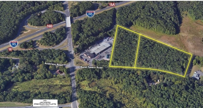
Property Record
37 Burnt Tavern Rd, Millstone Township, NJ 08510


NEARBY LISTINGS FOR SALE OR LEASE
-
-
-
No Photo
-
-
View all Millstone Township listings for sale on LoopNet.com
Property Detail
37 Burnt Tavern Rd
33-00057-0000-00017-03
Monmouth
Vacantlandnec
New Jersey
X
17.4
34025C0266F
10.88 AC
2024
Western Monmouth
2025
Northern New Jersey
812502
Lakewood-New Brunswick, NJ
DEMOGRAPHICS near 37 Burnt Tavern Rd
1 Mile
3 Mile
5 Mile
2024 Total Population
722
8,573
21,996
2029 Population
739
8,750
22,635
Pop Growth 2024-2029
+ 2.35%
+ 2.06%
+ 2.91%
Average Age
39
40
40
2024 Total Households
221
2,664
7,366
HH Growth 2024-2029
+ 1.81%
+ 1.46%
+ 2.76%
Median Household Inc
$164,285
$160,583
$132,978
Avg Household Size
3.10
3.10
2.90
2024 Avg HH Vehicles
3.00
3.00
3.00
Median Home Value
$588,843
$582,189
$496,781
Median Year Built
1991
1991
1990
Nearby Places
Map Layers
Map Styles
 Street
 Aerial
- Restaurants
- Banks
- Shops
- Fitness
- Groceries
PUBLIC TRANSPORTATION
AIRPORT
Trenton Mercer
DRIVE
WALK
Distance
Trenton Mercer
37 min
26.4 mi
Freight Ports
New York Container Terminal
DRIVE
WALK
Distance
New York Container Terminal
58 min
42.6 mi
SALE & LEASE HISTORY
LISTING DATE
SALE/LEASE

Jun 11, 2019
For Sale
Jan 10, 2024
For Sale
Jan 08, 2024
For Lease
Nearby Properties
Address
Land Use
TOTAL SIZE
Lot Size
Zoning
Address
Land Use
TOTAL SIZE
Lot Size
Zoning
908.18 AC
CR-1
Address
Land Use
TOTAL SIZE
Lot Size
Zoning
39.08 AC
HCMU
Address
Land Use
TOTAL SIZE
Lot Size
Zoning
55.83 AC
HC
Address
Land Use
TOTAL SIZE
Lot Size
Zoning
33.61 AC
HCMU
Address
Land Use
TOTAL SIZE
Lot Size
Zoning
30.60 AC
PFE
Address
Land Use
TOTAL SIZE
Lot Size
Zoning
88.35 AC
R-E
Address
Land Use
TOTAL SIZE
Lot Size
Zoning
86.85 AC
R-E
Address
Land Use
TOTAL SIZE
Lot Size
Zoning
17.57 AC
PFE
Address
Land Use
TOTAL SIZE
Lot Size
Zoning
25.47 AC
HC
Address
Land Use
TOTAL SIZE
Lot Size
Zoning
78.40 AC
HC
Address
Land Use
TOTAL SIZE
Lot Size
Zoning
44.29 AC
R-E
Address
Land Use
TOTAL SIZE
Lot Size
Zoning
866 SF
9.32 AC
LC
Address
Land Use
TOTAL SIZE
Lot Size
Zoning
43.76 AC
R-E
Address
Land Use
TOTAL SIZE
Lot Size
Zoning
17.18 AC
HC
Address
Land Use
TOTAL SIZE
Lot Size
Zoning
39.50 AC
R-E
Address
Land Use
TOTAL SIZE
Lot Size
Zoning
39.36 AC
R-40
Address
Land Use
TOTAL SIZE
Lot Size
Zoning
6.08 AC
BP
Address
Land Use
TOTAL SIZE
Lot Size
Zoning
1,080 SF
30.22 AC
SF80
Address
Land Use
TOTAL SIZE
Lot Size
Zoning
37.17 AC
R-E
Address
Land Use
TOTAL SIZE
Lot Size
Zoning
19.90 AC
LM
Address
Land Use
TOTAL SIZE
Lot Size
Zoning
6.14 AC
HC
Address
Land Use
TOTAL SIZE
Lot Size
Zoning
952.97 AC
ROS
Address
Land Use
TOTAL SIZE
Lot Size
Zoning
34.28 AC
R-E
Address
Land Use
TOTAL SIZE
Lot Size
Zoning
34.28 AC
R-E
Address
Land Use
TOTAL SIZE
Lot Size
Zoning
15.49 AC
SF80
Address
Land Use
TOTAL SIZE
Lot Size
Zoning
2 AC
HC
Address
Land Use
TOTAL SIZE
Lot Size
Zoning
30.06 AC
R-E
Address
Land Use
TOTAL SIZE
Lot Size
Zoning
30.06 AC
R-E
Address
Land Use
TOTAL SIZE
Lot Size
Zoning
4.39 AC
CR1
Address
Land Use
TOTAL SIZE
Lot Size
Zoning
26.20 AC
R-E
The World's #1 Commercial Real Estate Marketplace
Connect with us
© 2026 CoStar Group
The information above has been obtained from sources believed reliable. While we do not doubt its accuracy we have not verified it and make no guarantee, warranty or representation about it. It is your responsibility to independently confirm its accuracy and completeness. Any projections, opinions, assumptions, or estimates used are for example only and do not represent the current or future performance of the property. The value of this transaction to you depends on tax and other factors which should be evaluated by your tax, financial, and legal advisors. You and your advisors should conduct a careful, independent investigation of the property to determine to your satisfaction the suitability of the property for your needs.