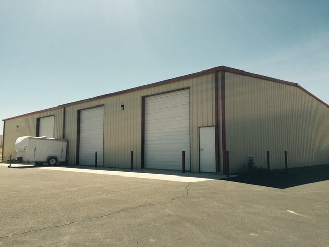
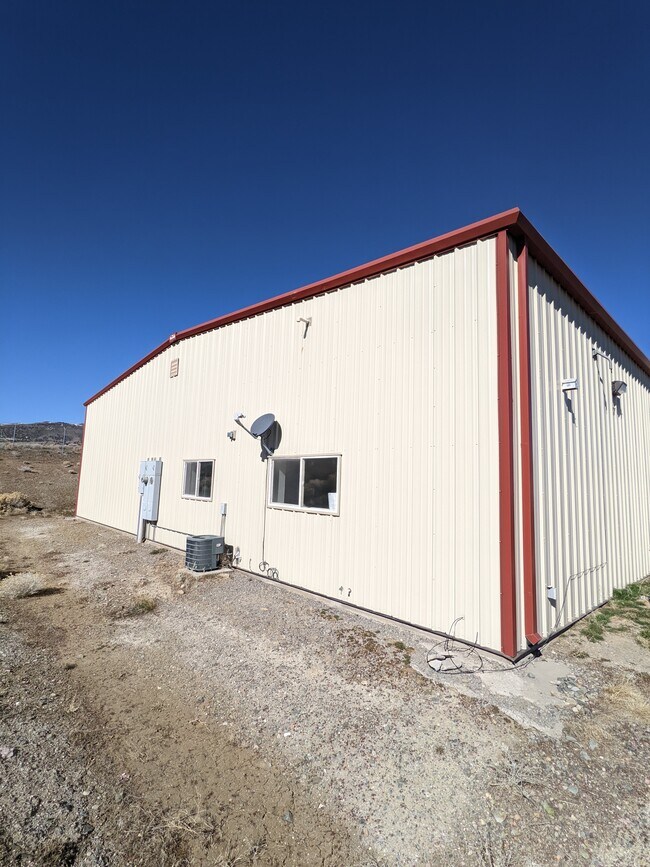
Property Record
37 Carry Way, Mound House, NV 89706

NEARBY LISTINGS FOR SALE OR LEASE
Property Detail
37 Carry Way
Fernley, NV
Diamondback Parcels
016-186-14
30-16-21 FRE2NE4NE4 CREATED FROM SPLIT OF PARCEL # 016-151-66 PRIMARY NEW PARCEL IS PARCEL # 016-151-74 DIAMONDBACK PARCELS ROS #287687 CHANGED FROM PARCEL # 016-151-91
Lightindustrial
Lyon
X
Nevada
3200010110F
39
2026
1.05 AC
2025
S Lyon County
960301
Reno/Sparks
6,000 SF
DEMOGRAPHICS near 37 Carry Way
1 Mile
3 Mile
5 Mile
2024 Total Population
493
1,625
11,038
2029 Population
511
1,723
11,341
Pop Growth 2024-2029
+ 3.65%
+ 6.03%
+ 2.75%
Average Age
43
43
43
2024 Total Households
197
643
4,300
HH Growth 2024-2029
+ 3.55%
+ 6.07%
+ 2.67%
Median Household Inc
$67,083
$66,048
$77,884
Avg Household Size
2.50
2.50
2.50
2024 Avg HH Vehicles
3.00
2.00
2.00
Median Home Value
$274,615
$299,199
$319,416
Median Year Built
1987
1988
1984
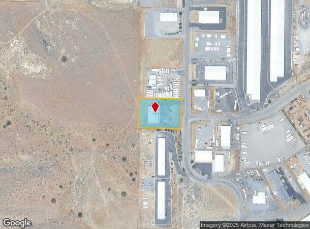
Nearby Places
Map Layers
Map Styles
 Street
 Aerial
- Restaurants
- Banks
- Shops
- Fitness
- Groceries
PUBLIC TRANSPORTATION
AIRPORT
Reno/Tahoe International
DRIVE
WALK
Distance
Reno/Tahoe International
63 min
38.1 mi
Freight Ports
Port of Stockton
DRIVE
WALK
Distance
Port of Stockton
232 min
159.9 mi
SALE & LEASE HISTORY
LISTING DATE
SALE/LEASE

Sep 25, 2016
For Lease
Feb 24, 2022
For Lease
Aug 09, 2021
For Sale
Nearby Properties
Address
Land Use
TOTAL SIZE
Lot Size
Zoning
Address
Land Use
TOTAL SIZE
Lot Size
Zoning
240 AC
PR
Address
Land Use
TOTAL SIZE
Lot Size
Zoning
375 SF
520 AC
PR
Address
Land Use
TOTAL SIZE
Lot Size
Zoning
270 AC
PC
Address
Land Use
TOTAL SIZE
Lot Size
Zoning
200 AC
PC
Address
Land Use
TOTAL SIZE
Lot Size
Zoning
4.51 AC
RR3
Address
Land Use
TOTAL SIZE
Lot Size
Zoning
100,947 SF
15 AC
M1
Address
Land Use
TOTAL SIZE
Lot Size
Zoning
108.58 AC
PR
Address
Land Use
TOTAL SIZE
Lot Size
Zoning
83,961 SF
10 AC
M1
Address
Land Use
TOTAL SIZE
Lot Size
Zoning
1,590 SF
10.16 AC
M1
Address
Land Use
TOTAL SIZE
Lot Size
Zoning
28,000 SF
7.78 AC
M1
Address
Land Use
TOTAL SIZE
Lot Size
Zoning
22,200 SF
4.27 AC
M1
Address
Land Use
TOTAL SIZE
Lot Size
Zoning
69,600 SF
5.85 AC
M1
Address
Land Use
TOTAL SIZE
Lot Size
Zoning
86,500 SF
6.41 AC
M1
Address
Land Use
TOTAL SIZE
Lot Size
Zoning
27,000 SF
6.19 AC
M1
Address
Land Use
TOTAL SIZE
Lot Size
Zoning
4,950 SF
2.69 AC
M1
Address
Land Use
TOTAL SIZE
Lot Size
Zoning
38,800 SF
20.84 AC
GI
Address
Land Use
TOTAL SIZE
Lot Size
Zoning
331.93 AC
PR
Address
Land Use
TOTAL SIZE
Lot Size
Zoning
65.50 AC
PR
Address
Land Use
TOTAL SIZE
Lot Size
Zoning
2,795 SF
7.05 AC
JW
Address
Land Use
TOTAL SIZE
Lot Size
Zoning
46.22 AC
PR-GC
Address
Land Use
TOTAL SIZE
Lot Size
Zoning
10,875 SF
15.10 AC
GI
Address
Land Use
TOTAL SIZE
Lot Size
Zoning
28,425 SF
3.85 AC
M1
Address
Land Use
TOTAL SIZE
Lot Size
Zoning
34,700 SF
5.35 AC
M1
Address
Land Use
TOTAL SIZE
Lot Size
Zoning
41,550 SF
17.81 AC
MFA
Address
Land Use
TOTAL SIZE
Lot Size
Zoning
4,350 SF
2.50 AC
M1
Address
Land Use
TOTAL SIZE
Lot Size
Zoning
33,600 SF
3.90 AC
M1
Address
Land Use
TOTAL SIZE
Lot Size
Zoning
42,100 SF
2.04 AC
GI
Address
Land Use
TOTAL SIZE
Lot Size
Zoning
15.32 AC
Address
Land Use
TOTAL SIZE
Lot Size
Zoning
10,000 SF
8.31 AC
M1
Address
Land Use
TOTAL SIZE
Lot Size
Zoning
4,648 SF
4.97 AC
GI
The World's #1 Commercial Real Estate Marketplace
Connect with us
© 2025 CoStar Group
The information above has been obtained from sources believed reliable. While we do not doubt its accuracy we have not verified it and make no guarantee, warranty or representation about it. It is your responsibility to independently confirm its accuracy and completeness. Any projections, opinions, assumptions, or estimates used are for example only and do not represent the current or future performance of the property. The value of this transaction to you depends on tax and other factors which should be evaluated by your tax, financial, and legal advisors. You and your advisors should conduct a careful, independent investigation of the property to determine to your satisfaction the suitability of the property for your needs.