Property Record
37 E Cross St, Ypsilanti, MI 48198
NEARBY LISTINGS FOR SALE OR LEASE
Property Detail
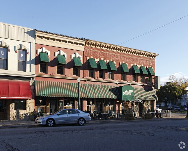
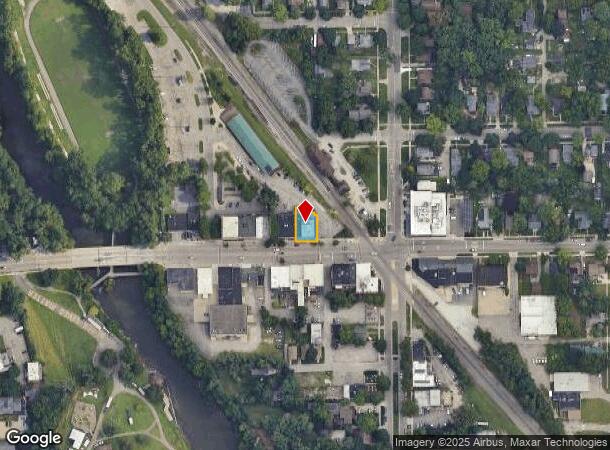
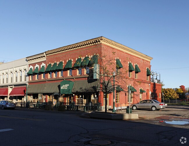
37 E Cross St
Ann Arbor, MI
Norris & Cross Add
11-04-463-013
BNDRY ADJST PER QCD L4148 P88 OWNER REQUEST YPC 25E-1A-1 BEG AT SE COR LOT 271 TH N 73.00 FT, TH W 8.00 FT, TH N 8.00 FT, TH W 32.00 FT, TH N 13.17 FT, TH W 20.00 FT, TH S 94.17 FT, TH E 60.68 FT TO THE POB. PT OF LOTS 271 & 272 NORRIS & CROSS ADDITI
Commercialnec
Washtenaw
X
Michigan
26161C0426E
271-272
2025
0.12 AC
2025
Washtenaw E of 23
410900
Detroit
7,192 SF
DEMOGRAPHICS near 37 E Cross St
1 Mile
3 Mile
5 Mile
2024 Total Population
14,640
67,644
121,027
2029 Population
14,523
66,911
119,673
Pop Growth 2024-2029
(0.80%)
(1.08%)
(1.12%)
Average Age
34
37
37
2024 Total Households
6,410
29,118
50,509
HH Growth 2024-2029
(1.08%)
(1.26%)
(1.26%)
Median Household Inc
$41,538
$48,674
$59,659
Avg Household Size
1.90
2.20
2.30
2024 Avg HH Vehicles
1.00
2.00
2.00
Median Home Value
$168,181
$165,053
$217,645
Median Year Built
1954
1969
1976
Nearby Places
Map Layers
Map Styles
 Street
 Aerial
- Restaurants
- Banks
- Shops
- Fitness
- Groceries
PUBLIC TRANSPORTATION
COMMUTER RAIL
Ann Arbor Amtrak Station (Wolverine - Amtrak)
DRIVE
WALK
Distance
Ann Arbor Amtrak Station (Wolverine - Amtrak)
16 min
8.2 mi
AIRPORT
Detroit Metro Wayne County
DRIVE
WALK
Distance
Detroit Metro Wayne County
25 min
18.4 mi
Freight Ports
Port of Toledo
DRIVE
WALK
Distance
Port of Toledo
75 min
60.1 mi
Nearby Properties
Address
Land Use
TOTAL SIZE
Lot Size
Zoning
Address
Land Use
TOTAL SIZE
Lot Size
Zoning
169,963 SF
86.24 AC
P-M
Address
Land Use
TOTAL SIZE
Lot Size
Zoning
36,000 SF
27.61 AC
BI
Address
Land Use
TOTAL SIZE
Lot Size
Zoning
38,001 SF
177.04 AC
BA
Address
Land Use
TOTAL SIZE
Lot Size
Zoning
118,166 SF
P-M
Address
Land Use
TOTAL SIZE
Lot Size
Zoning
361,634 SF
17.09 AC
Address
Land Use
TOTAL SIZE
Lot Size
Zoning
480 SF
23.64 AC
BI
Address
Land Use
TOTAL SIZE
Lot Size
Zoning
27,306 SF
16.08 AC
BI
Address
Land Use
TOTAL SIZE
Lot Size
Zoning
16,472 SF
29 AC
Address
Land Use
TOTAL SIZE
Lot Size
Zoning
30.77 AC
P-C
Address
Land Use
TOTAL SIZE
Lot Size
Zoning
168,450 SF
8.47 AC
Address
Land Use
TOTAL SIZE
Lot Size
Zoning
1,344 SF
18.17 AC
SPLIT
Address
Land Use
TOTAL SIZE
Lot Size
Zoning
26,146 SF
7.35 AC
BI
Address
Land Use
TOTAL SIZE
Lot Size
Zoning
11,204 SF
28 AC
Address
Land Use
TOTAL SIZE
Lot Size
Zoning
27,060 SF
11.47 AC
SPLIT
Address
Land Use
TOTAL SIZE
Lot Size
Zoning
27,060 SF
5.53 AC
SPLIT
Address
Land Use
TOTAL SIZE
Lot Size
Zoning
12,747 SF
22.86 AC
BA
Address
Land Use
TOTAL SIZE
Lot Size
Zoning
19,692 SF
21.22 AC
BA
Address
Land Use
TOTAL SIZE
Lot Size
Zoning
6,192 SF
19.02 AC
BA
Address
Land Use
TOTAL SIZE
Lot Size
Zoning
32,974 SF
29.96 AC
BA
Address
Land Use
TOTAL SIZE
Lot Size
Zoning
11,630 SF
17.36 AC
BA
Address
Land Use
TOTAL SIZE
Lot Size
Zoning
259,778 SF
25.39 AC
Address
Land Use
TOTAL SIZE
Lot Size
Zoning
26,550 SF
5.44 AC
MD
Address
Land Use
TOTAL SIZE
Lot Size
Zoning
15,877 SF
60 AC
Address
Land Use
TOTAL SIZE
Lot Size
Zoning
960 SF
15 AC
BA
Address
Land Use
TOTAL SIZE
Lot Size
Zoning
48,756 SF
5 AC
CN
Address
Land Use
TOTAL SIZE
Lot Size
Zoning
12,747 SF
17.90 AC
BA
Address
Land Use
TOTAL SIZE
Lot Size
Zoning
29,502 SF
11.29 AC
BA
Address
Land Use
TOTAL SIZE
Lot Size
Zoning
124,513 SF
3.79 AC
GC
Address
Land Use
TOTAL SIZE
Lot Size
Zoning
227,900 SF
1.97 AC
M-S
Address
Land Use
TOTAL SIZE
Lot Size
Zoning
31,575 SF
6.64 AC
BA
The World's #1 Commercial Real Estate Marketplace
Connect with us
© 2025 CoStar Group
The information above has been obtained from sources believed reliable. While we do not doubt its accuracy we have not verified it and make no guarantee, warranty or representation about it. It is your responsibility to independently confirm its accuracy and completeness. Any projections, opinions, assumptions, or estimates used are for example only and do not represent the current or future performance of the property. The value of this transaction to you depends on tax and other factors which should be evaluated by your tax, financial, and legal advisors. You and your advisors should conduct a careful, independent investigation of the property to determine to your satisfaction the suitability of the property for your needs.