Property Record
37 Edgerton Dr, North Falmouth, MA 02556
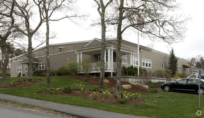
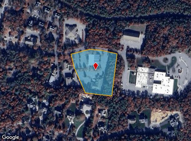

This Property Is For Sale
NEARBY LISTINGS FOR SALE OR LEASE
Property Detail
37 Edgerton Dr
Commercialcondominium
Barnstable
X
Massachusetts
25001C0513J
3u
2025
Cape Cod
2025
Other Market Areas
014300
Barnstable Town, MA
2,284 SF
FALM-000005-000010-000019B-000003-U
DEMOGRAPHICS near 37 Edgerton Dr
1 Mile
3 Mile
5 Mile
2024 Total Population
1,906
8,529
22,452
2029 Population
1,897
8,655
22,686
Pop Growth 2024-2029
(0.47%)
+ 1.48%
+ 1.04%
Average Age
50
49
48
2024 Total Households
812
3,517
9,555
HH Growth 2024-2029
(0.99%)
+ 1.14%
+ 0.71%
Median Household Inc
$141,477
$101,615
$89,332
Avg Household Size
2.20
2.30
2.30
2024 Avg HH Vehicles
2.00
2.00
2.00
Median Home Value
$639,560
$662,902
$486,915
Median Year Built
1983
1981
1979
Nearby Places
Map Layers
Map Styles
 Street
 Aerial
- Restaurants
- Banks
- Shops
- Fitness
- Groceries
PUBLIC TRANSPORTATION
COMMUTER RAIL
Bourne (CapeFLYER - Cape Cod Regional Transit Authority)
DRIVE
WALK
Distance
Bourne (CapeFLYER - Cape Cod Regional Transit Authority)
14 min
8.6 mi
AIRPORT
Martha's Vineyard
DRIVE
WALK
Distance
Martha's Vineyard
79 min
23.9 mi
Freight Ports
Port of New Bedford Harbor
DRIVE
WALK
Distance
Port of New Bedford Harbor
49 min
35.9 mi
Nearby Properties
Address
Land Use
TOTAL SIZE
Lot Size
Zoning
Address
Land Use
TOTAL SIZE
Lot Size
Zoning
191,993 SF
21.60 AC
RB
Address
Land Use
TOTAL SIZE
Lot Size
Zoning
5,067 SF
314.59 AC
PU
Address
Land Use
TOTAL SIZE
Lot Size
Zoning
22,000 SF
749.29 AC
GD
Address
Land Use
TOTAL SIZE
Lot Size
Zoning
53,202 SF
29.20 AC
PU
Address
Land Use
TOTAL SIZE
Lot Size
Zoning
61,751 SF
9.87 AC
Address
Land Use
TOTAL SIZE
Lot Size
Zoning
6,516 SF
88.49 AC
AGAA
Address
Land Use
TOTAL SIZE
Lot Size
Zoning
11.20 AC
Address
Land Use
TOTAL SIZE
Lot Size
Zoning
17.50 AC
Address
Land Use
TOTAL SIZE
Lot Size
Zoning
83,825 SF
8.06 AC
LIB
Address
Land Use
TOTAL SIZE
Lot Size
Zoning
1,199 SF
3.70 AC
R40
Address
Land Use
TOTAL SIZE
Lot Size
Zoning
59,250 SF
4.78 AC
LIB
Address
Land Use
TOTAL SIZE
Lot Size
Zoning
21,711 SF
157.40 AC
AGAA
Address
Land Use
TOTAL SIZE
Lot Size
Zoning
5,887 SF
1.58 AC
R40
Address
Land Use
TOTAL SIZE
Lot Size
Zoning
57,806 SF
14.39 AC
LIA
Address
Land Use
TOTAL SIZE
Lot Size
Zoning
6,081 SF
1.74 AC
RB
Address
Land Use
TOTAL SIZE
Lot Size
Zoning
6,355 SF
3.77 AC
RA
Address
Land Use
TOTAL SIZE
Lot Size
Zoning
65.92 AC
AGA
Address
Land Use
TOTAL SIZE
Lot Size
Zoning
3,172 SF
2.23 AC
R40
Address
Land Use
TOTAL SIZE
Lot Size
Zoning
6,912 SF
1.95 AC
RB
Address
Land Use
TOTAL SIZE
Lot Size
Zoning
25,713 SF
4.70 AC
M
Address
Land Use
TOTAL SIZE
Lot Size
Zoning
1.41 AC
R40
Address
Land Use
TOTAL SIZE
Lot Size
Zoning
5,597 SF
1.37 AC
R40
Address
Land Use
TOTAL SIZE
Lot Size
Zoning
1.56 AC
R40
Address
Land Use
TOTAL SIZE
Lot Size
Zoning
10,000 SF
80.22 AC
AGAA
Address
Land Use
TOTAL SIZE
Lot Size
Zoning
5,332 SF
1.55 AC
R40
Address
Land Use
TOTAL SIZE
Lot Size
Zoning
3,429 SF
1.24 AC
R40
Address
Land Use
TOTAL SIZE
Lot Size
Zoning
6,853 SF
4.30 AC
R40
Address
Land Use
TOTAL SIZE
Lot Size
Zoning
6,413 SF
3.23 AC
R40
Address
Land Use
TOTAL SIZE
Lot Size
Zoning
5,150 SF
2.41 AC
R40
Address
Land Use
TOTAL SIZE
Lot Size
Zoning
1,568 SF
1.72 AC
R40
The World's #1 Commercial Real Estate Marketplace
Connect with us
© 2025 CoStar Group
The information above has been obtained from sources believed reliable. While we do not doubt its accuracy we have not verified it and make no guarantee, warranty or representation about it. It is your responsibility to independently confirm its accuracy and completeness. Any projections, opinions, assumptions, or estimates used are for example only and do not represent the current or future performance of the property. The value of this transaction to you depends on tax and other factors which should be evaluated by your tax, financial, and legal advisors. You and your advisors should conduct a careful, independent investigation of the property to determine to your satisfaction the suitability of the property for your needs.