Property Record
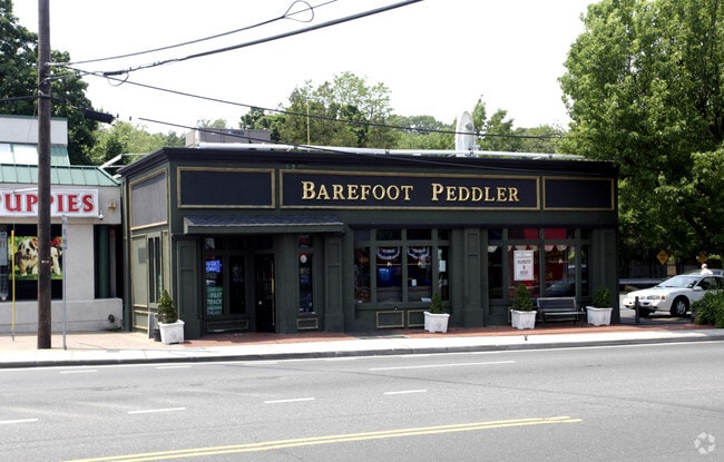
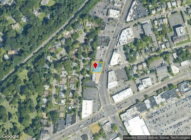
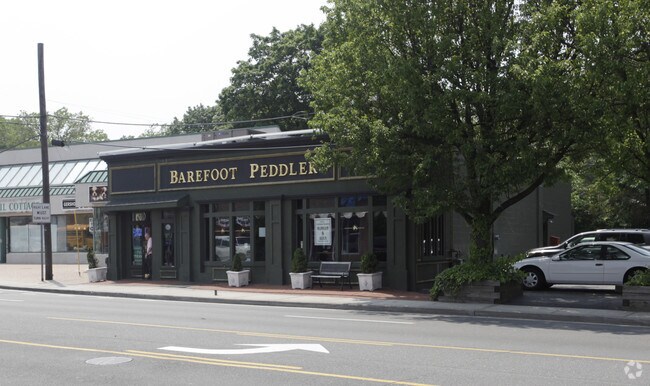
37 Glen Cove Rd, Greenvale, NY 11548
NEARBY LISTINGS FOR SALE OR LEASE
Property Detail
37 Glen Cove Rd
Nassau County-Suffolk County, NY
North Roslyn Dev
2289-20-070-00-0020-0
12-16
Restaurantbuilding
Nassau
X
New York
36059C0117G
20
2025
0.24 AC
2025
Northern Nassau
302101
Long Island (New York)
5,762 SF
DEMOGRAPHICS near 37 Glen Cove Rd
1 Mile
3 Mile
5 Mile
2024 Total Population
5,999
59,416
230,950
2029 Population
5,906
58,620
227,942
Pop Growth 2024-2029
(1.55%)
(1.34%)
(1.30%)
Average Age
42
42
42
2024 Total Households
1,930
19,826
77,747
HH Growth 2024-2029
(1.71%)
(1.49%)
(1.34%)
Median Household Inc
$196,359
$167,252
$134,567
Avg Household Size
3.10
2.90
2.80
2024 Avg HH Vehicles
2.00
2.00
2.00
Median Home Value
$1,065,804
$969,033
$828,175
Median Year Built
1958
1956
1956
Nearby Places
- Restaurants
- Banks
- Shops
- Fitness
- Groceries
PUBLIC TRANSPORTATION
COMMUTER RAIL
Greenvale Station (Oyster Bay Branch - Long Island Rail Road)
DRIVE
WALK
Distance
Greenvale Station (Oyster Bay Branch - Long Island Rail Road)
2 min
7 min
0.4 mi
Glen Head Station (Oyster Bay Branch - Long Island Rail Road)
DRIVE
WALK
Distance
Glen Head Station (Oyster Bay Branch - Long Island Rail Road)
5 min
2.0 mi
AIRPORT
LaGuardia
DRIVE
WALK
Distance
LaGuardia
29 min
17.5 mi
John F Kennedy International
DRIVE
WALK
Distance
John F Kennedy International
31 min
19.3 mi
Westchester County
DRIVE
WALK
Distance
Westchester County
58 min
36.3 mi
Freight Ports
NY - Red Hook Container Terminal
DRIVE
WALK
Distance
NY - Red Hook Container Terminal
40 min
25.6 mi
Nearby Properties
Address
Land Use
TOTAL SIZE
Lot Size
Zoning
Address
Land Use
TOTAL SIZE
Lot Size
Zoning
600 SF
2.68 AC
Address
Land Use
TOTAL SIZE
Lot Size
Zoning
95.70 AC
Address
Land Use
TOTAL SIZE
Lot Size
Zoning
375,331 SF
14.83 AC
Address
Land Use
TOTAL SIZE
Lot Size
Zoning
251,828 SF
31.03 AC
Address
Land Use
TOTAL SIZE
Lot Size
Zoning
83,566 SF
38.12 AC
Address
Land Use
TOTAL SIZE
Lot Size
Zoning
26,200 SF
186 AC
Address
Land Use
TOTAL SIZE
Lot Size
Zoning
158,725 SF
24.46 AC
Address
Land Use
TOTAL SIZE
Lot Size
Zoning
401,583 SF
17.93 AC
Address
Land Use
TOTAL SIZE
Lot Size
Zoning
50,252 SF
143.04 AC
Address
Land Use
TOTAL SIZE
Lot Size
Zoning
49,950 SF
51.02 AC
Address
Land Use
TOTAL SIZE
Lot Size
Zoning
171,770 SF
5.95 AC
Address
Land Use
TOTAL SIZE
Lot Size
Zoning
179,365 SF
6.05 AC
Address
Land Use
TOTAL SIZE
Lot Size
Zoning
45,898 SF
85.13 AC
Address
Land Use
TOTAL SIZE
Lot Size
Zoning
98,439 SF
8.94 AC
Address
Land Use
TOTAL SIZE
Lot Size
Zoning
56,663 SF
388.75 AC
Address
Land Use
TOTAL SIZE
Lot Size
Zoning
161,595 SF
29.91 AC
Address
Land Use
TOTAL SIZE
Lot Size
Zoning
109,503 SF
12.88 AC
Address
Land Use
TOTAL SIZE
Lot Size
Zoning
140,916 SF
3.14 AC
Address
Land Use
TOTAL SIZE
Lot Size
Zoning
80,013 SF
51.03 AC
Address
Land Use
TOTAL SIZE
Lot Size
Zoning
130,665 SF
9.91 AC
Address
Land Use
TOTAL SIZE
Lot Size
Zoning
51,868 SF
44.24 AC
Address
Land Use
TOTAL SIZE
Lot Size
Zoning
62,607 SF
2.63 AC
Address
Land Use
TOTAL SIZE
Lot Size
Zoning
125,184 SF
9.58 AC
Address
Land Use
TOTAL SIZE
Lot Size
Zoning
183,394 SF
18.70 AC
Address
Land Use
TOTAL SIZE
Lot Size
Zoning
30,477 SF
78.71 AC
Address
Land Use
TOTAL SIZE
Lot Size
Zoning
2,214 SF
131.50 AC
Address
Land Use
TOTAL SIZE
Lot Size
Zoning
85,980 SF
16.20 AC
Address
Land Use
TOTAL SIZE
Lot Size
Zoning
8,034 SF
15.75 AC
Address
Land Use
TOTAL SIZE
Lot Size
Zoning
81,205 SF
9.96 AC
Address
Land Use
TOTAL SIZE
Lot Size
Zoning
487,862 SF
21.75 AC
The World's #1 Commercial Real Estate Marketplace
Connect with us
© 2025 CoStar Group
The information above has been obtained from sources believed reliable. While we do not doubt its accuracy we have not verified it and make no guarantee, warranty or representation about it. It is your responsibility to independently confirm its accuracy and completeness. Any projections, opinions, assumptions, or estimates used are for example only and do not represent the current or future performance of the property. The value of this transaction to you depends on tax and other factors which should be evaluated by your tax, financial, and legal advisors. You and your advisors should conduct a careful, independent investigation of the property to determine to your satisfaction the suitability of the property for your needs.