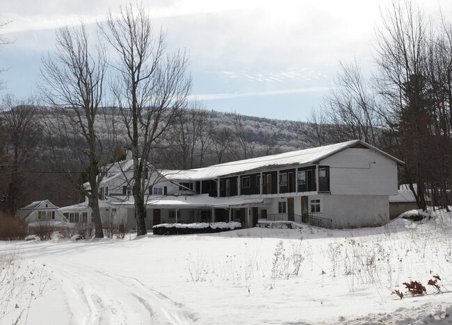
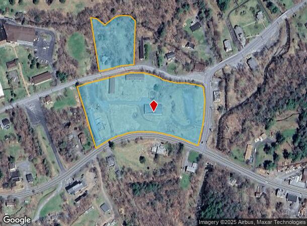
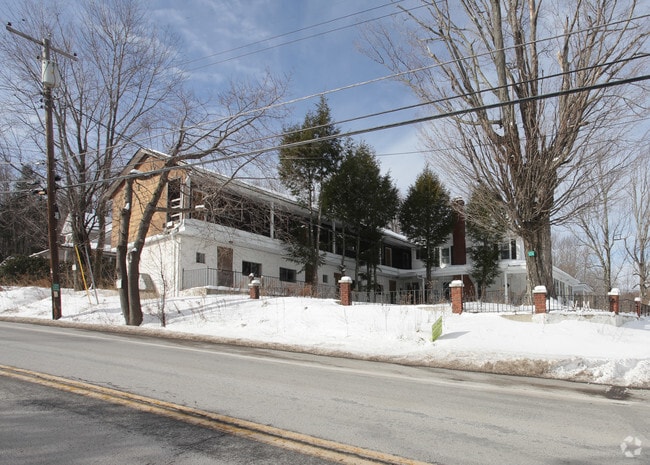
Property Record
37 Ohara Rd, Haines Falls, NY 12436
NEARBY LISTINGS FOR SALE OR LEASE
-
-
View all Haines Falls listings for sale on LoopNet.com
Property Detail
37 Ohara Rd
Outdoorrecreationbeachmountaindesert
Greene
A
New York
36039C0405G
24.000
2025
6.80 AC
2024
New York Southeast Area
080403
Albany/Schenectady/Troy
9,383 SF
193689-166-020-0002-024-000-0000
DEMOGRAPHICS near 37 Ohara Rd
1 Mile
3 Mile
5 Mile
2024 Total Population
475
1,347
3,165
2029 Population
450
1,281
3,116
Pop Growth 2024-2029
(5.26%)
(4.90%)
(1.55%)
Average Age
42
41
43
2024 Total Households
180
475
1,237
HH Growth 2024-2029
(6.11%)
(6.11%)
(1.78%)
Median Household Inc
$62,678
$63,823
$64,500
Avg Household Size
2.20
2.20
2.20
2024 Avg HH Vehicles
2.00
2.00
2.00
Median Home Value
$377,777
$291,538
$225,893
Median Year Built
1975
1974
1968
Nearby Places
- Restaurants
- Banks
- Shops
- Fitness
- Groceries
Nearby Properties
Address
Land Use
TOTAL SIZE
Lot Size
Zoning
Address
Land Use
TOTAL SIZE
Lot Size
Zoning
0.01 AC
01 - NOT Z
Address
Land Use
TOTAL SIZE
Lot Size
Zoning
61,470 SF
6.60 AC
01 - NOT Z
Address
Land Use
TOTAL SIZE
Lot Size
Zoning
37,208 SF
291 AC
01 - NOT Z
Address
Land Use
TOTAL SIZE
Lot Size
Zoning
2,345 SF
2.10 AC
01 - NOT Z
Address
Land Use
TOTAL SIZE
Lot Size
Zoning
1,646.20 AC
01 - NOT Z
Address
Land Use
TOTAL SIZE
Lot Size
Zoning
43,162 SF
3.50 AC
01 - NOT Z
Address
Land Use
TOTAL SIZE
Lot Size
Zoning
23,600 SF
2.80 AC
01 - NOT Z
Address
Land Use
TOTAL SIZE
Lot Size
Zoning
6,860 SF
107.90 AC
01 - NOT Z
Address
Land Use
TOTAL SIZE
Lot Size
Zoning
617.60 AC
01 - NOT Z
Address
Land Use
TOTAL SIZE
Lot Size
Zoning
4,299 SF
1.60 AC
RC
Address
Land Use
TOTAL SIZE
Lot Size
Zoning
710.40 AC
01 - NOT Z
Address
Land Use
TOTAL SIZE
Lot Size
Zoning
312.40 AC
C
Address
Land Use
TOTAL SIZE
Lot Size
Zoning
185 AC
01 - NOT Z
Address
Land Use
TOTAL SIZE
Lot Size
Zoning
5,946 SF
3.40 AC
01 - NOT Z
Address
Land Use
TOTAL SIZE
Lot Size
Zoning
10,138 SF
1.50 AC
01 - NOT Z
Address
Land Use
TOTAL SIZE
Lot Size
Zoning
4,511 SF
38.90 AC
01 - NOT Z
Address
Land Use
TOTAL SIZE
Lot Size
Zoning
12,850 SF
4.70 AC
01 - NOT Z
Address
Land Use
TOTAL SIZE
Lot Size
Zoning
2,688 SF
1.52 AC
01 - NOT Z
Address
Land Use
TOTAL SIZE
Lot Size
Zoning
487.50 AC
01 - NOT Z
Address
Land Use
TOTAL SIZE
Lot Size
Zoning
6,540 SF
15 AC
01 - NOT Z
Address
Land Use
TOTAL SIZE
Lot Size
Zoning
9,196 SF
1.90 AC
01 - NOT Z
Address
Land Use
TOTAL SIZE
Lot Size
Zoning
12,960 SF
0.79 AC
01 - NOT Z
Address
Land Use
TOTAL SIZE
Lot Size
Zoning
8,356 SF
0.77 AC
01 - NOT Z
Address
Land Use
TOTAL SIZE
Lot Size
Zoning
5,760 SF
4.60 AC
01 - NOT Z
Address
Land Use
TOTAL SIZE
Lot Size
Zoning
200.70 AC
01 - NOT Z
Address
Land Use
TOTAL SIZE
Lot Size
Zoning
72 AC
01 - NOT Z
Address
Land Use
TOTAL SIZE
Lot Size
Zoning
2,857 SF
50.10 AC
01 - NOT Z
Address
Land Use
TOTAL SIZE
Lot Size
Zoning
334.60 AC
01 - NOT Z
Address
Land Use
TOTAL SIZE
Lot Size
Zoning
1,575 SF
54.40 AC
01 - NOT Z
Address
Land Use
TOTAL SIZE
Lot Size
Zoning
359.10 AC
01 - NOT Z
The World's #1 Commercial Real Estate Marketplace
Connect with us
© 2025 CoStar Group
The information above has been obtained from sources believed reliable. While we do not doubt its accuracy we have not verified it and make no guarantee, warranty or representation about it. It is your responsibility to independently confirm its accuracy and completeness. Any projections, opinions, assumptions, or estimates used are for example only and do not represent the current or future performance of the property. The value of this transaction to you depends on tax and other factors which should be evaluated by your tax, financial, and legal advisors. You and your advisors should conduct a careful, independent investigation of the property to determine to your satisfaction the suitability of the property for your needs.