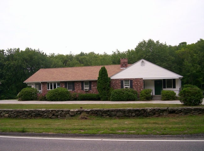
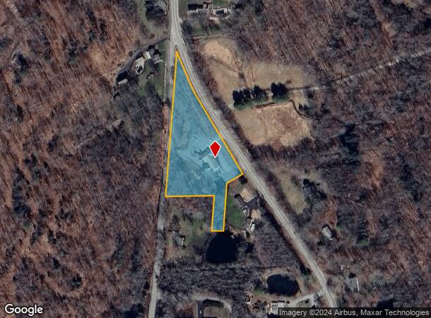
Property Record
37 S Canterbury Rd, Canterbury, CT 06331
NEARBY LISTINGS FOR SALE OR LEASE
Property Detail
37 S Canterbury Rd
CANT-000055-000000-000018
Windham
Commercialbuilding
Connecticut
2025
2.26 AC
2025
Windham County
906100
Hartford
2,725 SF
Worcester, MA-CT
DEMOGRAPHICS near 37 S Canterbury Rd
1 Mile
3 Mile
5 Mile
2024 Total Population
474
5,179
18,408
2029 Population
474
5,172
18,312
Pop Growth 2024-2029
0.00%
(0.14%)
(0.52%)
Average Age
44
43
42
2024 Total Households
190
2,066
7,186
HH Growth 2024-2029
0.00%
(0.15%)
(0.50%)
Median Household Inc
$87,121
$73,852
$75,820
Avg Household Size
2.50
2.40
2.50
2024 Avg HH Vehicles
2.00
2.00
2.00
Median Home Value
$257,432
$226,239
$238,461
Median Year Built
1972
1969
1972
Nearby Places
Map Layers
Map Styles
 Street
 Aerial
- Restaurants
- Banks
- Shops
- Fitness
- Groceries
PUBLIC TRANSPORTATION
AIRPORT
Rhode Island Tf Green International
DRIVE
WALK
Distance
Rhode Island Tf Green International
56 min
39.9 mi
Freight Ports
Port of Davisville, RI
DRIVE
WALK
Distance
Port of Davisville, RI
68 min
49.2 mi
SALE & LEASE HISTORY
LISTING DATE
SALE/LEASE

Feb 03, 2020
For Sale
Nearby Properties
Address
Land Use
TOTAL SIZE
Lot Size
Zoning
Address
Land Use
TOTAL SIZE
Lot Size
Zoning
202.19 AC
IND
Address
Land Use
TOTAL SIZE
Lot Size
Zoning
37.12 AC
RA60
Address
Land Use
TOTAL SIZE
Lot Size
Zoning
47,065 SF
26.27 AC
Address
Land Use
TOTAL SIZE
Lot Size
Zoning
Address
Land Use
TOTAL SIZE
Lot Size
Zoning
35,165 SF
6.63 AC
RA30
Address
Land Use
TOTAL SIZE
Lot Size
Zoning
800 SF
15.50 AC
Address
Land Use
TOTAL SIZE
Lot Size
Zoning
Address
Land Use
TOTAL SIZE
Lot Size
Zoning
11,893 SF
9.84 AC
Address
Land Use
TOTAL SIZE
Lot Size
Zoning
8.30 AC
RA30
Address
Land Use
TOTAL SIZE
Lot Size
Zoning
13,812 SF
1.70 AC
RA19
Address
Land Use
TOTAL SIZE
Lot Size
Zoning
334 AC
RA60
Address
Land Use
TOTAL SIZE
Lot Size
Zoning
52.63 AC
IND-1
Address
Land Use
TOTAL SIZE
Lot Size
Zoning
4,072 SF
1 AC
Address
Land Use
TOTAL SIZE
Lot Size
Zoning
19,512 SF
12.52 AC
Address
Land Use
TOTAL SIZE
Lot Size
Zoning
0.23 AC
IP
Address
Land Use
TOTAL SIZE
Lot Size
Zoning
29,640 SF
2.72 AC
RA60
Address
Land Use
TOTAL SIZE
Lot Size
Zoning
29,447 SF
2.50 AC
C
Address
Land Use
TOTAL SIZE
Lot Size
Zoning
18,610 SF
3.88 AC
RA30
Address
Land Use
TOTAL SIZE
Lot Size
Zoning
31.40 AC
RA60
Address
Land Use
TOTAL SIZE
Lot Size
Zoning
11,984 SF
2.81 AC
Address
Land Use
TOTAL SIZE
Lot Size
Zoning
16,839 SF
1.10 AC
C2
Address
Land Use
TOTAL SIZE
Lot Size
Zoning
Address
Land Use
TOTAL SIZE
Lot Size
Zoning
2.06 AC
RA30
Address
Land Use
TOTAL SIZE
Lot Size
Zoning
7,308 SF
0.60 AC
Address
Land Use
TOTAL SIZE
Lot Size
Zoning
10,000 SF
4.02 AC
Address
Land Use
TOTAL SIZE
Lot Size
Zoning
17,888 SF
2.44 AC
RA30
Address
Land Use
TOTAL SIZE
Lot Size
Zoning
51.23 AC
Address
Land Use
TOTAL SIZE
Lot Size
Zoning
26,076 SF
9 AC
IND
Address
Land Use
TOTAL SIZE
Lot Size
Zoning
580,837 SF
15.65 AC
IND-1
Address
Land Use
TOTAL SIZE
Lot Size
Zoning
26 AC
RA60
The World's #1 Commercial Real Estate Marketplace
Connect with us
© 2025 CoStar Group
The information above has been obtained from sources believed reliable. While we do not doubt its accuracy we have not verified it and make no guarantee, warranty or representation about it. It is your responsibility to independently confirm its accuracy and completeness. Any projections, opinions, assumptions, or estimates used are for example only and do not represent the current or future performance of the property. The value of this transaction to you depends on tax and other factors which should be evaluated by your tax, financial, and legal advisors. You and your advisors should conduct a careful, independent investigation of the property to determine to your satisfaction the suitability of the property for your needs.