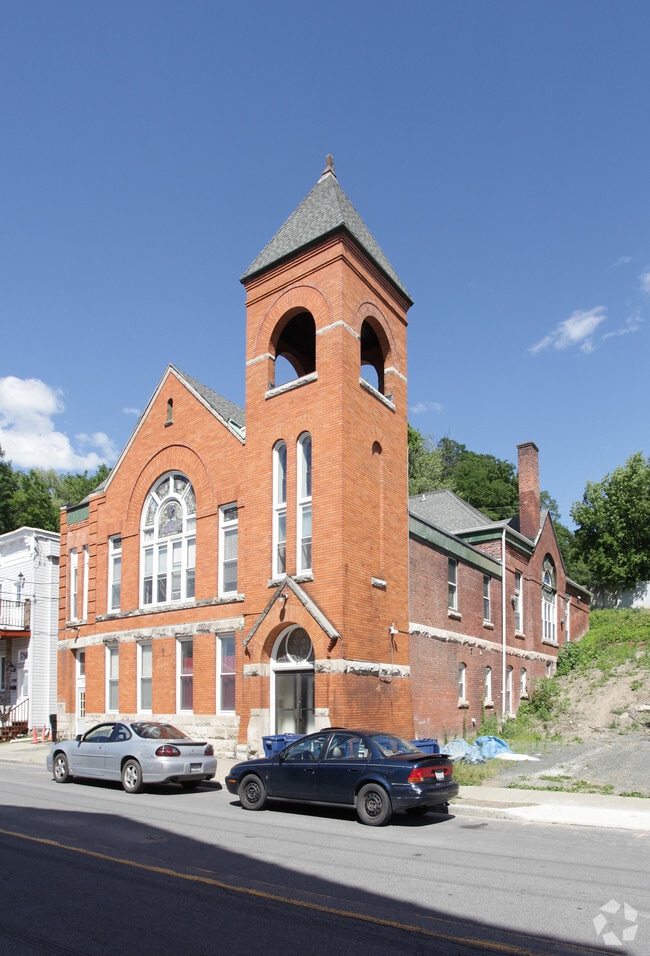
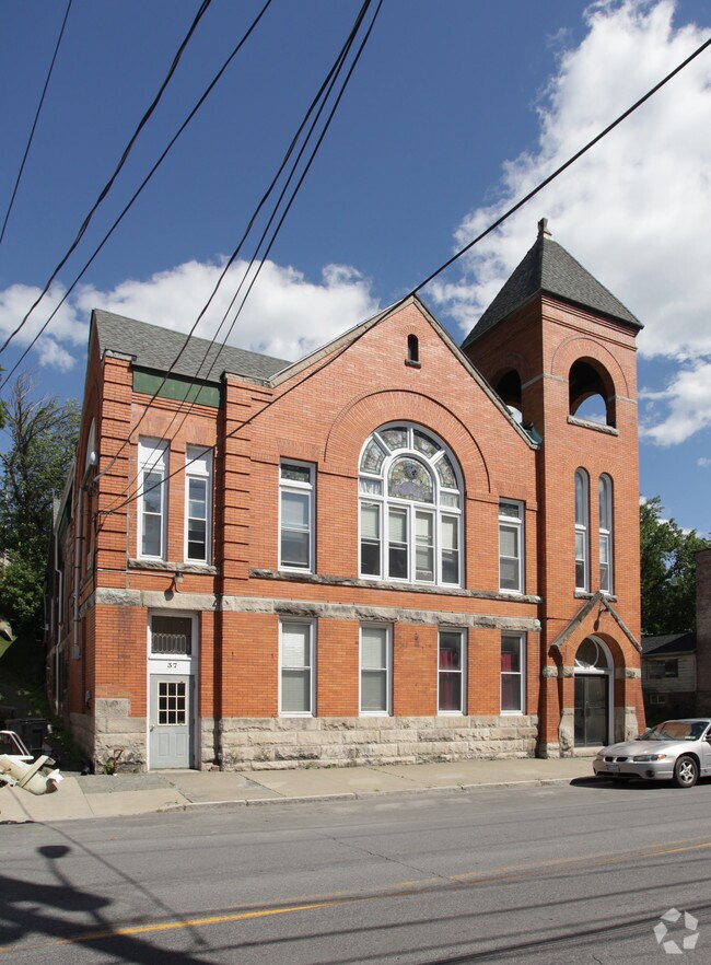
Property Record
37 S Main St, Castleton, NY 12033


Save to a Folder
{{folder.Name}}
{{folder.ListingIds.length}} Properties
{{folder.ListingIds.length}} Property
Create a New Folder
Property Detail
37 S Main St
Albany-Schenectady-Troy, NY
BACK REF 1539/13
4401-198.15-1-31
Rensselaer
Apartment
New York
HDO
31.000
2025
0.36 AC
2025
Outer Rensselaer County
052503
Albany/Schenectady/Troy
15,000 SF
NEARBY LISTINGS FOR SALE OR LEASE
DEMOGRAPHICS near 37 S Main St
1 mile
3 mile
5 mile
2025 Total Population
1,752
6,186
21,605
2030 Population
1,776
6,265
21,877
Pop Growth 2025-2030
+ 1.37%
+ 1.28%
+ 1.26%
Average Age
41
43
43
2025 Total Households
675
2,518
8,781
HH Growth 2025-2030
+ 1.33%
+ 1.31%
+ 1.28%
Median Household Inc
$74,391
$91,632
$98,173
Avg Household Size
2.50
2.40
2.40
2025 Avg HH Vehicles
2.00
2.00
2.00
Median Home Value
$215,110
$250,000
$277,702
Median Year Built
1948
1962
1973
Nearby Places
Map Layers
Map Styles
 Street
 Aerial
Layers
 Traffic
 Biking
Places
Listings with unknown addresses are not visible on the map
- Restaurants
- Banks
- Shops
- Fitness
- Groceries
PUBLIC TRANSPORTATION
COMMUTER RAIL
Drive
Walk
Distance
15 min
8.4 mi
AIRPORT
Albany International
Drive
Walk
Distance
Albany International
38 min
19.4 mi
Nearby Properties
Address
Land Use
TOTAL SIZE
Lot Size
Zoning
Address
Land Use
TOTAL SIZE
Lot Size
Zoning
168.80 AC
Address
Land Use
TOTAL SIZE
Lot Size
Zoning
102,995 SF
153.50 AC
RR
Address
Land Use
TOTAL SIZE
Lot Size
Zoning
108,473 SF
62.61 AC
R-40
Address
Land Use
TOTAL SIZE
Lot Size
Zoning
Address
Land Use
TOTAL SIZE
Lot Size
Zoning
10,288 SF
17.20 AC
RLI
Address
Land Use
TOTAL SIZE
Lot Size
Zoning
1,140 SF
127.59 AC
I
Address
Land Use
TOTAL SIZE
Lot Size
Zoning
44,430 SF
11.86 AC
R
Address
Land Use
TOTAL SIZE
Lot Size
Zoning
1,594 SF
11.38 AC
R
Address
Land Use
TOTAL SIZE
Lot Size
Zoning
Address
Land Use
TOTAL SIZE
Lot Size
Zoning
Address
Land Use
TOTAL SIZE
Lot Size
Zoning
924 SF
36.80 AC
RLI
Address
Land Use
TOTAL SIZE
Lot Size
Zoning
30,276 SF
26.52 AC
ME
Address
Land Use
TOTAL SIZE
Lot Size
Zoning
Address
Land Use
TOTAL SIZE
Lot Size
Zoning
31,078 SF
7.50 AC
R
Address
Land Use
TOTAL SIZE
Lot Size
Zoning
2,088 SF
165.25 AC
I-3 P
Address
Land Use
TOTAL SIZE
Lot Size
Zoning
101.26 AC
Address
Land Use
TOTAL SIZE
Lot Size
Zoning
1,848 SF
5.70 AC
R
Address
Land Use
TOTAL SIZE
Lot Size
Zoning
26,940 SF
25.20 AC
RLI
Address
Land Use
TOTAL SIZE
Lot Size
Zoning
27.46 AC
RA
Address
Land Use
TOTAL SIZE
Lot Size
Zoning
30.30 AC
I-3P
Address
Land Use
TOTAL SIZE
Lot Size
Zoning
7,608 SF
16.50 AC
RR
Address
Land Use
TOTAL SIZE
Lot Size
Zoning
Address
Land Use
TOTAL SIZE
Lot Size
Zoning
84.70 AC
RR
Address
Land Use
TOTAL SIZE
Lot Size
Zoning
13,873 SF
10.01 AC
RLI
Address
Land Use
TOTAL SIZE
Lot Size
Zoning
108,000 SF
27.97 AC
M
Address
Land Use
TOTAL SIZE
Lot Size
Zoning
506 SF
8 AC
RLI
Address
Land Use
TOTAL SIZE
Lot Size
Zoning
5,582 SF
1.90 AC
RR
Address
Land Use
TOTAL SIZE
Lot Size
Zoning
Address
Land Use
TOTAL SIZE
Lot Size
Zoning
10,849 SF
7.25 AC
R-40
Address
Land Use
TOTAL SIZE
Lot Size
Zoning
14.12 AC
The World's #1 Commercial Real Estate Marketplace
Connect with us
© 2026 CoStar Group
The information above has been obtained from sources believed reliable. While we do not doubt its accuracy we have not verified it and make no guarantee, warranty or representation about it. It is your responsibility to independently confirm its accuracy and completeness. Any projections, opinions, assumptions, or estimates used are for example only and do not represent the current or future performance of the property. The value of this transaction to you depends on tax and other factors which should be evaluated by your tax, financial, and legal advisors. You and your advisors should conduct a careful, independent investigation of the property to determine to your satisfaction the suitability of the property for your needs.