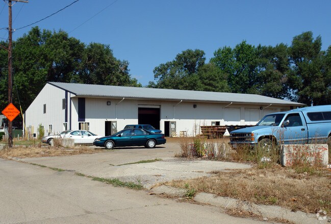
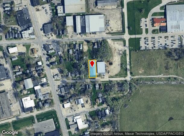
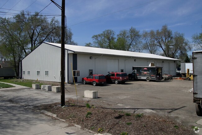
Property Record
37 Tyler St, Toledo, OH 43612
NEARBY LISTINGS FOR SALE OR LEASE
Property Detail
37 Tyler St
Toledo, OH
Creek Side Addition
03-26541
CREEK SIDE ADDITION LOT 22
Parkingstructure
Lucas
X
Ohio
39095C0083F
22
0
0.26 AC
2025
North Toledo
000900
Toledo
9,792 SF
DEMOGRAPHICS near 37 Tyler St
1 Mile
3 Mile
5 Mile
2024 Total Population
9,877
88,014
218,153
2029 Population
9,843
88,015
217,369
Pop Growth 2024-2029
(0.34%)
0.00%
(0.36%)
Average Age
36
37
38
2024 Total Households
3,965
37,314
91,406
HH Growth 2024-2029
(0.45%)
(0.01%)
(0.43%)
Median Household Inc
$37,220
$36,875
$42,324
Avg Household Size
2.40
2.20
2.20
2024 Avg HH Vehicles
1.00
1.00
2.00
Median Home Value
$57,783
$74,256
$94,859
Median Year Built
1947
1948
1952
Nearby Places
Map Layers
Map Styles
 Street
 Aerial
- Restaurants
- Banks
- Shops
- Fitness
- Groceries
PUBLIC TRANSPORTATION
COMMUTER RAIL
Toledo (Capitol Limited - Amtrak, Lake Shore Limited - Amtrak)
DRIVE
WALK
Distance
Toledo (Capitol Limited - Amtrak, Lake Shore Limited - Amtrak)
9 min
4.5 mi
AIRPORT
Eugene F Kranz Toledo Express
DRIVE
WALK
Distance
Eugene F Kranz Toledo Express
38 min
22.7 mi
Freight Ports
Port of Toledo
DRIVE
WALK
Distance
Port of Toledo
17 min
7.9 mi
Nearby Properties
Address
Land Use
TOTAL SIZE
Lot Size
Zoning
Address
Land Use
TOTAL SIZE
Lot Size
Zoning
3,101,694 SF
35.64 AC
10-IC
Address
Land Use
TOTAL SIZE
Lot Size
Zoning
1,046,727 SF
0.41 AC
10-IC
Address
Land Use
TOTAL SIZE
Lot Size
Zoning
569,999 SF
45.25 AC
10-MX
Address
Land Use
TOTAL SIZE
Lot Size
Zoning
277,862 SF
3 AC
10-CD
Address
Land Use
TOTAL SIZE
Lot Size
Zoning
169.42 AC
10-IG
Address
Land Use
TOTAL SIZE
Lot Size
Zoning
1,972,579 SF
76.32 AC
10-IG
Address
Land Use
TOTAL SIZE
Lot Size
Zoning
304,593 SF
24.13 AC
10-IC
Address
Land Use
TOTAL SIZE
Lot Size
Zoning
693,900 SF
76.32 AC
10-IG
Address
Land Use
TOTAL SIZE
Lot Size
Zoning
448,269 SF
29.52 AC
10-IC
Address
Land Use
TOTAL SIZE
Lot Size
Zoning
625,485 SF
2 AC
10-MX
Address
Land Use
TOTAL SIZE
Lot Size
Zoning
111,471 SF
6.17 AC
10-CD
Address
Land Use
TOTAL SIZE
Lot Size
Zoning
171,946 SF
0.17 AC
10-IC
Address
Land Use
TOTAL SIZE
Lot Size
Zoning
Address
Land Use
TOTAL SIZE
Lot Size
Zoning
328,568 SF
16.37 AC
10-CO
Address
Land Use
TOTAL SIZE
Lot Size
Zoning
296,348 SF
1 AC
10-CO
Address
Land Use
TOTAL SIZE
Lot Size
Zoning
76.32 AC
10-IG
Address
Land Use
TOTAL SIZE
Lot Size
Zoning
169.42 AC
10-IG
Address
Land Use
TOTAL SIZE
Lot Size
Zoning
375,323 SF
10-IC
Address
Land Use
TOTAL SIZE
Lot Size
Zoning
72,306 SF
0.09 AC
10-IC
Address
Land Use
TOTAL SIZE
Lot Size
Zoning
182,983 SF
2 AC
10-CD
Address
Land Use
TOTAL SIZE
Lot Size
Zoning
317,139 SF
25.80 AC
10-IC
Address
Land Use
TOTAL SIZE
Lot Size
Zoning
33.48 AC
10-IG
Address
Land Use
TOTAL SIZE
Lot Size
Zoning
172,044 SF
12.78 AC
10-MX
Address
Land Use
TOTAL SIZE
Lot Size
Zoning
390,272 SF
5 AC
10-CD
Address
Land Use
TOTAL SIZE
Lot Size
Zoning
228,692 SF
10.45 AC
10-RM36
Address
Land Use
TOTAL SIZE
Lot Size
Zoning
202,118 SF
1.50 AC
10-CD
Address
Land Use
TOTAL SIZE
Lot Size
Zoning
232,758 SF
2 AC
10-CO
Address
Land Use
TOTAL SIZE
Lot Size
Zoning
297,666 SF
4 AC
10-CO
Address
Land Use
TOTAL SIZE
Lot Size
Zoning
90,113 SF
11.83 AC
10-RS6
Address
Land Use
TOTAL SIZE
Lot Size
Zoning
132,690 SF
5 AC
10-CO
The World's #1 Commercial Real Estate Marketplace
Connect with us
© 2026 CoStar Group
The information above has been obtained from sources believed reliable. While we do not doubt its accuracy we have not verified it and make no guarantee, warranty or representation about it. It is your responsibility to independently confirm its accuracy and completeness. Any projections, opinions, assumptions, or estimates used are for example only and do not represent the current or future performance of the property. The value of this transaction to you depends on tax and other factors which should be evaluated by your tax, financial, and legal advisors. You and your advisors should conduct a careful, independent investigation of the property to determine to your satisfaction the suitability of the property for your needs.