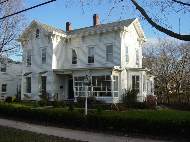
Property Record
37 W Broad St, Hopewell, NJ 08525
NEARBY LISTINGS FOR SALE OR LEASE
-
-
View all Hopewell listings for lease on LoopNet.com
Property Detail
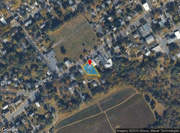
37 W Broad St
05-00025-0000-00066
Mercer
Vacantlandnec
New Jersey
AE
66
34021C0019F
0.32 AC
2024
Trenton
2025
Northern New Jersey
003902
Trenton, NJ
2,533 SF
DEMOGRAPHICS near 37 W Broad St
1 Mile
3 Mile
5 Mile
2024 Total Population
2,262
7,364
20,683
2029 Population
2,229
7,279
20,547
Pop Growth 2024-2029
(1.46%)
(1.15%)
(0.66%)
Average Age
43
43
43
2024 Total Households
915
2,685
7,390
HH Growth 2024-2029
(1.64%)
(1.27%)
(0.70%)
Median Household Inc
$134,404
$181,920
$181,801
Avg Household Size
2.50
2.70
2.70
2024 Avg HH Vehicles
2.00
2.00
2.00
Median Home Value
$484,258
$643,907
$683,863
Median Year Built
1949
1969
1973
Nearby Places
Map Layers
Map Styles
 Street
 Aerial
- Restaurants
- Banks
- Shops
- Fitness
- Groceries
PUBLIC TRANSPORTATION
COMMUTER RAIL
Princeton (Princeton Branch - NJ Transit Commuter Rail (NJ Transit))
DRIVE
WALK
Distance
Princeton (Princeton Branch - NJ Transit Commuter Rail (NJ Transit))
19 min
8.5 mi
AIRPORT
Trenton Mercer
DRIVE
WALK
Distance
Trenton Mercer
21 min
10.3 mi
Freight Ports
Port of Philadelphia
DRIVE
WALK
Distance
Port of Philadelphia
58 min
38.6 mi
SALE & LEASE HISTORY
LISTING DATE
SALE/LEASE

Oct 14, 2018
For Lease
May 07, 2018
For Lease
Jan 02, 2019
For Lease
Nearby Properties
Address
Land Use
TOTAL SIZE
Lot Size
Zoning
Address
Land Use
TOTAL SIZE
Lot Size
Zoning
42 AC
R03
Address
Land Use
TOTAL SIZE
Lot Size
Zoning
156.92 AC
R03
Address
Land Use
TOTAL SIZE
Lot Size
Zoning
Address
Land Use
TOTAL SIZE
Lot Size
Zoning
Address
Land Use
TOTAL SIZE
Lot Size
Zoning
Address
Land Use
TOTAL SIZE
Lot Size
Zoning
Address
Land Use
TOTAL SIZE
Lot Size
Zoning
Address
Land Use
TOTAL SIZE
Lot Size
Zoning
50.53 AC
2ZON
Address
Land Use
TOTAL SIZE
Lot Size
Zoning
8.67 AC
R75P
Address
Land Use
TOTAL SIZE
Lot Size
Zoning
4.87 AC
C1
Address
Land Use
TOTAL SIZE
Lot Size
Zoning
10,226 SF
226.63 AC
2ZON
Address
Land Use
TOTAL SIZE
Lot Size
Zoning
12,213 SF
4.50 AC
MRC
Address
Land Use
TOTAL SIZE
Lot Size
Zoning
3,027 SF
77.84 AC
MRC
Address
Land Use
TOTAL SIZE
Lot Size
Zoning
48.34 AC
RO3
Address
Land Use
TOTAL SIZE
Lot Size
Zoning
182.43 AC
MRC
Address
Land Use
TOTAL SIZE
Lot Size
Zoning
174 AC
VRC
Address
Land Use
TOTAL SIZE
Lot Size
Zoning
2,083 SF
175.35 AC
Address
Land Use
TOTAL SIZE
Lot Size
Zoning
11,915 SF
3 AC
2ZON
Address
Land Use
TOTAL SIZE
Lot Size
Zoning
62,854 SF
18.06 AC
IC
Address
Land Use
TOTAL SIZE
Lot Size
Zoning
45.06 AC
R12
Address
Land Use
TOTAL SIZE
Lot Size
Zoning
18,973 SF
5 AC
VRC
Address
Land Use
TOTAL SIZE
Lot Size
Zoning
Address
Land Use
TOTAL SIZE
Lot Size
Zoning
249.48 AC
MTN
Address
Land Use
TOTAL SIZE
Lot Size
Zoning
2,520 SF
21.94 AC
SC-1
Address
Land Use
TOTAL SIZE
Lot Size
Zoning
120.48 AC
VRC
Address
Land Use
TOTAL SIZE
Lot Size
Zoning
10,089 SF
1.75 AC
VRC
Address
Land Use
TOTAL SIZE
Lot Size
Zoning
Address
Land Use
TOTAL SIZE
Lot Size
Zoning
1,681 SF
1.40 AC
R75P
Address
Land Use
TOTAL SIZE
Lot Size
Zoning
7,856 SF
3 AC
MRC
Address
Land Use
TOTAL SIZE
Lot Size
Zoning
6,942 SF
2 AC
VRC
The World's #1 Commercial Real Estate Marketplace
Connect with us
© 2025 CoStar Group
The information above has been obtained from sources believed reliable. While we do not doubt its accuracy we have not verified it and make no guarantee, warranty or representation about it. It is your responsibility to independently confirm its accuracy and completeness. Any projections, opinions, assumptions, or estimates used are for example only and do not represent the current or future performance of the property. The value of this transaction to you depends on tax and other factors which should be evaluated by your tax, financial, and legal advisors. You and your advisors should conduct a careful, independent investigation of the property to determine to your satisfaction the suitability of the property for your needs.