Property Record
370 E Irving Rd, Pahrump, NV 89060

Property Detail
370 E Irving Rd
Pahrump, NV
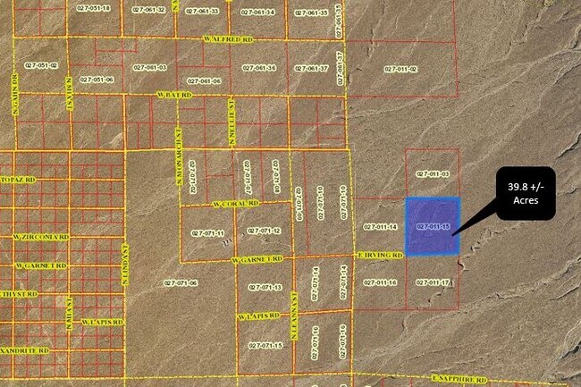
T18S R53E S22 F#475017 P.2 39.80AC
27-011-15
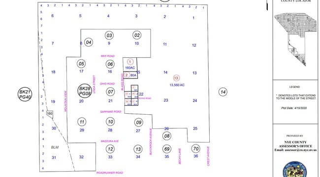
NYE
Residentialacreage
Nevada
RH-9.5
2
B and X Area of moderate flood hazard, usually the area between the limits of the 100-year and 500-year floods.
39.80 AC
2024
Carson City/Nevada Area
2025
Other Market Areas
960411
NEARBY LISTINGS FOR SALE OR LEASE
DEMOGRAPHICS near 370 E Irving Rd
1 mile
3 mile
5 mile
2025 Total Population
2
22
1,558
2030 Population
2
24
1,684
Pop Growth 2025-2030
0.00%
+ 9.09%
+ 8.09%
Average Age
0
49
51
2025 Total Households
1
9
676
HH Growth 2025-2030
0.00%
+ 11.11%
+ 7.99%
Median Household Inc
$0
$49,999
$50,263
Avg Household Size
.00
2.00
2.30
2025 Avg HH Vehicles
.00
2.00
2.00
Median Home Value
$0
$237,500
$244,491
Median Year Built
0
2000
2000
Nearby Places
Map Layers
Map Styles
 Street
 Aerial
Transit
 Traffic
 Biking
Places
Listings with unknown addresses are not visible on the map
- Restaurants
- Banks
- Shops
- Fitness
- Groceries
Nearby Properties
Address
Land Use
TOTAL SIZE
Lot Size
Zoning
Address
Land Use
TOTAL SIZE
Lot Size
Zoning
320 AC
R
Address
Land Use
TOTAL SIZE
Lot Size
Zoning
480 AC
R
Address
Land Use
TOTAL SIZE
Lot Size
Zoning
480 AC
R
Address
Land Use
TOTAL SIZE
Lot Size
Zoning
403 AC
RH-9.5
Address
Land Use
TOTAL SIZE
Lot Size
Zoning
310 AC
RH-9.5
Address
Land Use
TOTAL SIZE
Lot Size
Zoning
240 AC
RH-9.5
Address
Land Use
TOTAL SIZE
Lot Size
Zoning
160 AC
RH-9.5
Address
Land Use
TOTAL SIZE
Lot Size
Zoning
151.52 AC
RH95
Address
Land Use
TOTAL SIZE
Lot Size
Zoning
43.07 AC
RH-9.5
Address
Land Use
TOTAL SIZE
Lot Size
Zoning
120 AC
RH-9.5
Address
Land Use
TOTAL SIZE
Lot Size
Zoning
120 AC
RH-9.5
Address
Land Use
TOTAL SIZE
Lot Size
Zoning
41.13 AC
RH-9.5
Address
Land Use
TOTAL SIZE
Lot Size
Zoning
39.70 AC
RH-9.5
Address
Land Use
TOTAL SIZE
Lot Size
Zoning
40 AC
RH-9.5
Address
Land Use
TOTAL SIZE
Lot Size
Zoning
82.10 AC
RH-9.5
Address
Land Use
TOTAL SIZE
Lot Size
Zoning
80 AC
RH-9.5
Address
Land Use
TOTAL SIZE
Lot Size
Zoning
80 AC
RH-9.5
Address
Land Use
TOTAL SIZE
Lot Size
Zoning
80 AC
RH-9.5
Address
Land Use
TOTAL SIZE
Lot Size
Zoning
80 AC
RH-9.5
Address
Land Use
TOTAL SIZE
Lot Size
Zoning
80 AC
RH-9.5
Address
Land Use
TOTAL SIZE
Lot Size
Zoning
80 AC
RH-9.5
Address
Land Use
TOTAL SIZE
Lot Size
Zoning
80 AC
RH-9.5
Address
Land Use
TOTAL SIZE
Lot Size
Zoning
80 AC
RH-9.5
Address
Land Use
TOTAL SIZE
Lot Size
Zoning
80 AC
RH-9.5
Address
Land Use
TOTAL SIZE
Lot Size
Zoning
80 AC
RH-9.5
Address
Land Use
TOTAL SIZE
Lot Size
Zoning
1,600 SF
2.10 AC
RE-2
Address
Land Use
TOTAL SIZE
Lot Size
Zoning
62.74 AC
RH-9.5
Address
Land Use
TOTAL SIZE
Lot Size
Zoning
40.01 AC
RH-9.5
Address
Land Use
TOTAL SIZE
Lot Size
Zoning
38.70 AC
VR-20
Address
Land Use
TOTAL SIZE
Lot Size
Zoning
43 AC
RH-9.5
The World's #1 Commercial Real Estate Marketplace
Connect with us
© 2026 CoStar Group
The information above has been obtained from sources believed reliable. While we do not doubt its accuracy we have not verified it and make no guarantee, warranty or representation about it. It is your responsibility to independently confirm its accuracy and completeness. Any projections, opinions, assumptions, or estimates used are for example only and do not represent the current or future performance of the property. The value of this transaction to you depends on tax and other factors which should be evaluated by your tax, financial, and legal advisors. You and your advisors should conduct a careful, independent investigation of the property to determine to your satisfaction the suitability of the property for your needs.