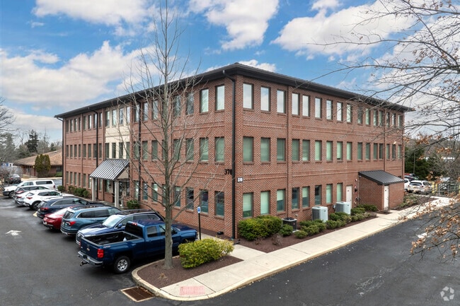
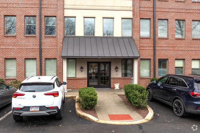
Property Record
370 E Maple Ave, Langhorne, PA 19047

Current Lease Availabilities
Property Detail
370 E Maple Ave
Philadelphia-Camden-Wilmington, PA-NJ-DE-MD
Maple Square 02
22-021-079
1.2377AC LOT #1 SS SR213 425 E CHERRY ST 209 ON SR213
Officebuilding
Bucks
X
Pennsylvania
42017C0441J
1
2024
1.24 AC
2025
Lower Bucks County
100807
Philadelphia
24,000 SF
NEARBY LISTINGS FOR SALE OR LEASE
DEMOGRAPHICS near 370 E Maple Ave
1 mile
3 mile
5 mile
2024 Total Population
6,529
74,972
207,945
2029 Population
6,505
74,666
206,698
Pop Growth 2024-2029
(0.37%)
(0.41%)
(0.60%)
Average Age
46
43
43
2024 Total Households
2,322
28,436
78,254
HH Growth 2024-2029
(0.43%)
(0.42%)
(0.67%)
Median Household Inc
$94,341
$105,482
$100,714
Avg Household Size
2.30
2.50
2.60
2024 Avg HH Vehicles
2.00
2.00
2.00
Median Home Value
$415,018
$370,309
$352,454
Median Year Built
1974
1975
1973
Nearby Places
Map Layers
Map Styles
 Street
 Aerial
Transit
 Traffic
 Biking
Places
Listings with unknown addresses are not visible on the map
- Restaurants
- Banks
- Shops
- Fitness
- Groceries
PUBLIC TRANSPORTATION
COMMUTER RAIL
Langhorne (R3 - Southeastern Pennsylvania Transportation Authority Regional Rail (SEPTA Regional Rail))
Drive
Walk
Distance
Langhorne (R3 - Southeastern Pennsylvania Transportation Authority Regional Rail (SEPTA Regional Rail))
4 min
1.5 mi
Woodbourne (R3 - Southeastern Pennsylvania Transportation Authority Regional Rail (SEPTA Regional Rail))
Drive
Walk
Distance
Woodbourne (R3 - Southeastern Pennsylvania Transportation Authority Regional Rail (SEPTA Regional Rail))
7 min
3.8 mi
AIRPORT
Trenton Mercer
Drive
Walk
Distance
Trenton Mercer
18 min
11.2 mi
Philadelphia International
Drive
Walk
Distance
Philadelphia International
52 min
34.7 mi
Nearby Properties
Address
Land Use
TOTAL SIZE
Lot Size
Zoning
Address
Land Use
TOTAL SIZE
Lot Size
Zoning
32,912 SF
42.06 AC
AO
Address
Land Use
TOTAL SIZE
Lot Size
Zoning
356,045 SF
7.67 AC
MOZ1
Address
Land Use
TOTAL SIZE
Lot Size
Zoning
4,982 SF
39 AC
C
Address
Land Use
TOTAL SIZE
Lot Size
Zoning
21.78 AC
R4
Address
Land Use
TOTAL SIZE
Lot Size
Zoning
116,591 SF
2.65 AC
MI
Address
Land Use
TOTAL SIZE
Lot Size
Zoning
282,799 SF
24.77 AC
GB
Address
Land Use
TOTAL SIZE
Lot Size
Zoning
19.95 AC
CD
Address
Land Use
TOTAL SIZE
Lot Size
Zoning
202,400 SF
20.98 AC
C
Address
Land Use
TOTAL SIZE
Lot Size
Zoning
730,540 SF
82.69 AC
GB
Address
Land Use
TOTAL SIZE
Lot Size
Zoning
72,540 SF
14.02 AC
CD
Address
Land Use
TOTAL SIZE
Lot Size
Zoning
57,804 SF
20.69 AC
AO
Address
Land Use
TOTAL SIZE
Lot Size
Zoning
3,490 SF
15.80 AC
R1
Address
Land Use
TOTAL SIZE
Lot Size
Zoning
171,918 SF
17.70 AC
AO
Address
Land Use
TOTAL SIZE
Lot Size
Zoning
102,348 SF
0.60 AC
RA
Address
Land Use
TOTAL SIZE
Lot Size
Zoning
104,204 SF
12.99 AC
RA3
Address
Land Use
TOTAL SIZE
Lot Size
Zoning
163,779 SF
20.10 AC
MI
Address
Land Use
TOTAL SIZE
Lot Size
Zoning
41,546 SF
11.67 AC
CD
Address
Land Use
TOTAL SIZE
Lot Size
Zoning
37,550 SF
5.18 AC
M1
Address
Land Use
TOTAL SIZE
Lot Size
Zoning
16,990 SF
2.83 AC
C
Address
Land Use
TOTAL SIZE
Lot Size
Zoning
93,562 SF
12.60 AC
AO
Address
Land Use
TOTAL SIZE
Lot Size
Zoning
16,170 SF
40 AC
OR
Address
Land Use
TOTAL SIZE
Lot Size
Zoning
116,120 SF
2.70 AC
MZO1
Address
Land Use
TOTAL SIZE
Lot Size
Zoning
33,084 SF
11.32 AC
CD
Address
Land Use
TOTAL SIZE
Lot Size
Zoning
26,340 SF
11.82 AC
CD
Address
Land Use
TOTAL SIZE
Lot Size
Zoning
33,528 SF
5.38 AC
P
Address
Land Use
TOTAL SIZE
Lot Size
Zoning
15,905 SF
8.43 AC
M1
Address
Land Use
TOTAL SIZE
Lot Size
Zoning
134,750 SF
12.87 AC
C
Address
Land Use
TOTAL SIZE
Lot Size
Zoning
75,089 SF
2.03 AC
R2
Address
Land Use
TOTAL SIZE
Lot Size
Zoning
91,910 SF
6.05 AC
GB
Address
Land Use
TOTAL SIZE
Lot Size
Zoning
78,848 SF
0.70 AC
The World's #1 Commercial Real Estate Marketplace
Connect with us
© 2026 CoStar Group
The information above has been obtained from sources believed reliable. While we do not doubt its accuracy we have not verified it and make no guarantee, warranty or representation about it. It is your responsibility to independently confirm its accuracy and completeness. Any projections, opinions, assumptions, or estimates used are for example only and do not represent the current or future performance of the property. The value of this transaction to you depends on tax and other factors which should be evaluated by your tax, financial, and legal advisors. You and your advisors should conduct a careful, independent investigation of the property to determine to your satisfaction the suitability of the property for your needs.