Property Record
370 Greenbrier Dr, Charlottesville, VA 22901
NEARBY LISTINGS FOR SALE OR LEASE
Property Detail
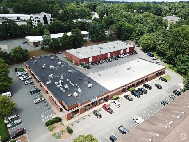
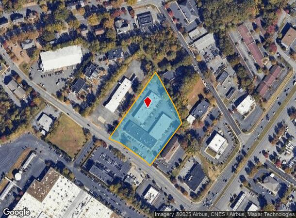
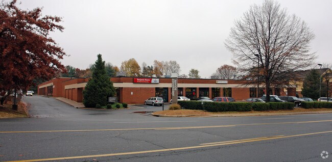
370 Greenbrier Dr
061W0-01-0A-00500
ACREAGE PARCEL B-1 T/A GREENBRIER SQUARE
Stripcommercialcenter
Albemarle
X
Virginia
51003C0278D
3.06 AC
2025
Charlottesville
2025
Other Market Areas
010702
Charlottesville, VA
26,040 SF
DEMOGRAPHICS near 370 Greenbrier Dr
1 Mile
3 Mile
5 Mile
2024 Total Population
13,602
59,129
104,074
2029 Population
14,034
59,973
105,306
Pop Growth 2024-2029
+ 3.18%
+ 1.43%
+ 1.18%
Average Age
40
37
37
2024 Total Households
5,904
22,961
42,120
HH Growth 2024-2029
+ 3.74%
+ 1.59%
+ 1.32%
Median Household Inc
$58,324
$70,199
$78,160
Avg Household Size
2.10
2.20
2.20
2024 Avg HH Vehicles
2.00
2.00
2.00
Median Home Value
$267,986
$429,673
$412,901
Median Year Built
1981
1981
1984
Nearby Places
Map Layers
Map Styles
 Street
 Aerial
- Restaurants
- Banks
- Shops
- Fitness
- Groceries
PUBLIC TRANSPORTATION
COMMUTER RAIL
DRIVE
WALK
Distance
10 min
3.9 mi
AIRPORT
Charlottesville-Albemarle
DRIVE
WALK
Distance
Charlottesville-Albemarle
14 min
6.7 mi
SALE & LEASE HISTORY
LISTING DATE
SALE/LEASE

Sep 25, 2016
For Lease
Sep 18, 2018
For Lease
Nearby Properties
Address
Land Use
TOTAL SIZE
Lot Size
Zoning
Address
Land Use
TOTAL SIZE
Lot Size
Zoning
872,960 SF
20.90 AC
CM
Address
Land Use
TOTAL SIZE
Lot Size
Zoning
45 AC
RURAL AREA
Address
Land Use
TOTAL SIZE
Lot Size
Zoning
13,125 SF
100.40 AC
R1 RESIDEN
Address
Land Use
TOTAL SIZE
Lot Size
Zoning
61,177 SF
30.40 AC
R1 RESIDEN
Address
Land Use
TOTAL SIZE
Lot Size
Zoning
15 AC
RURAL AREA
Address
Land Use
TOTAL SIZE
Lot Size
Zoning
34.70 AC
RURAL AREA
Address
Land Use
TOTAL SIZE
Lot Size
Zoning
167,708 SF
1.05 AC
CM
Address
Land Use
TOTAL SIZE
Lot Size
Zoning
497,658 SF
39.83 AC
NX-10
Address
Land Use
TOTAL SIZE
Lot Size
Zoning
3,465 SF
145.17 AC
CV
Address
Land Use
TOTAL SIZE
Lot Size
Zoning
254,749 SF
80.72 AC
CM
Address
Land Use
TOTAL SIZE
Lot Size
Zoning
45,873 SF
30 AC
RURAL AREA
Address
Land Use
TOTAL SIZE
Lot Size
Zoning
62,900 SF
4.71 AC
NX-10
Address
Land Use
TOTAL SIZE
Lot Size
Zoning
3,803 SF
266.70 AC
CV
Address
Land Use
TOTAL SIZE
Lot Size
Zoning
12,180 SF
26.20 AC
RURAL AREA
Address
Land Use
TOTAL SIZE
Lot Size
Zoning
578,208 SF
2.06 AC
CX-8
Address
Land Use
TOTAL SIZE
Lot Size
Zoning
43,616 SF
2.24 AC
CX-8
Address
Land Use
TOTAL SIZE
Lot Size
Zoning
10,270 SF
3.59 AC
RX-5
Address
Land Use
TOTAL SIZE
Lot Size
Zoning
12,876 SF
32.70 AC
NEIGHBORHO
Address
Land Use
TOTAL SIZE
Lot Size
Zoning
393,960 SF
16.14 AC
NMD
Address
Land Use
TOTAL SIZE
Lot Size
Zoning
30,896 SF
0.97 AC
DX
Address
Land Use
TOTAL SIZE
Lot Size
Zoning
78,332 SF
33.82 AC
CM
Address
Land Use
TOTAL SIZE
Lot Size
Zoning
240,936 SF
1.26 AC
NX-10
Address
Land Use
TOTAL SIZE
Lot Size
Zoning
46,770 SF
216.69 AC
RURAL AREA
Address
Land Use
TOTAL SIZE
Lot Size
Zoning
Address
Land Use
TOTAL SIZE
Lot Size
Zoning
195,000 SF
11.16 AC
R1 RESIDEN
Address
Land Use
TOTAL SIZE
Lot Size
Zoning
43,120 SF
4.08 AC
CM
Address
Land Use
TOTAL SIZE
Lot Size
Zoning
218,660 SF
1.27 AC
CX-8
Address
Land Use
TOTAL SIZE
Lot Size
Zoning
1.38 AC
CX-3
Address
Land Use
TOTAL SIZE
Lot Size
Zoning
263,304 SF
9.77 AC
R15 RESIDE
Address
Land Use
TOTAL SIZE
Lot Size
Zoning
110,969 SF
2.06 AC
CM
The World's #1 Commercial Real Estate Marketplace
Connect with us
© 2026 CoStar Group
The information above has been obtained from sources believed reliable. While we do not doubt its accuracy we have not verified it and make no guarantee, warranty or representation about it. It is your responsibility to independently confirm its accuracy and completeness. Any projections, opinions, assumptions, or estimates used are for example only and do not represent the current or future performance of the property. The value of this transaction to you depends on tax and other factors which should be evaluated by your tax, financial, and legal advisors. You and your advisors should conduct a careful, independent investigation of the property to determine to your satisfaction the suitability of the property for your needs.