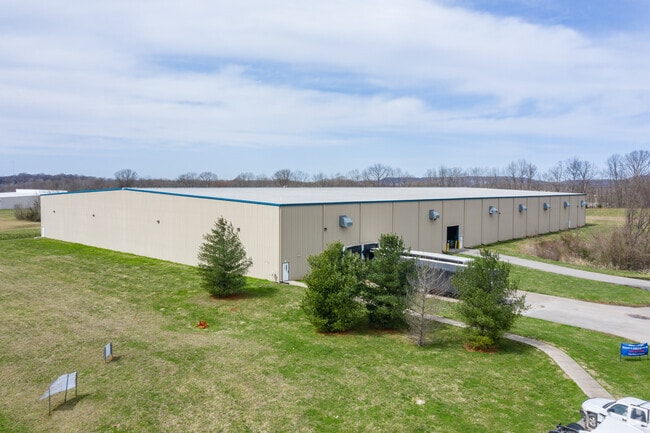
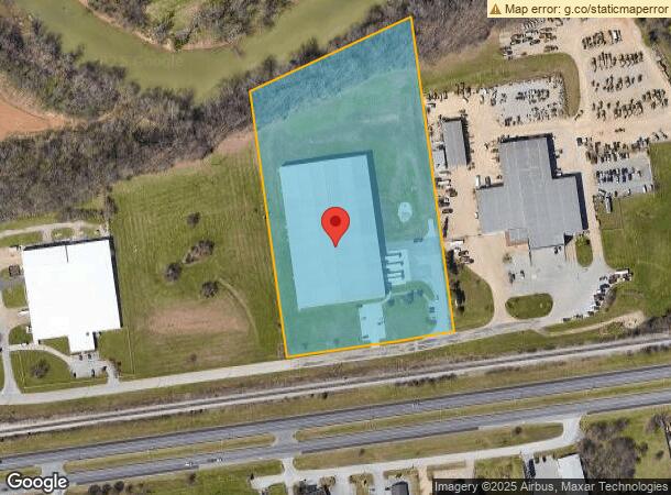
Property Record
370 High Rail Way, Bowling Green, KY 42101

Current Lease Availabilities
NEARBY LISTINGS FOR SALE OR LEASE
Property Detail
370 High Rail Way
Warehouse
Warren
AE
Kentucky
21227C0168E
9.22 AC
2025
Bowling Green Area
2025
Other Market Areas
011300
Bowling Green, KY
100,000 SF
050C-03-007
DEMOGRAPHICS near 370 High Rail Way
1 Mile
3 Mile
5 Mile
2024 Total Population
860
35,819
78,757
2029 Population
954
39,420
86,705
Pop Growth 2024-2029
+ 10.93%
+ 10.05%
+ 10.09%
Average Age
39
35
35
2024 Total Households
363
13,579
31,075
HH Growth 2024-2029
+ 11.29%
+ 11.22%
+ 10.82%
Median Household Inc
$62,625
$41,814
$44,511
Avg Household Size
2.30
2.20
2.30
2024 Avg HH Vehicles
2.00
2.00
2.00
Median Home Value
$238,059
$193,947
$196,125
Median Year Built
1996
1981
1988
Nearby Places
Map Layers
Map Styles
 Street
 Aerial
- Restaurants
- Banks
- Shops
- Fitness
- Groceries
Nearby Properties
Address
Land Use
TOTAL SIZE
Lot Size
Zoning
Address
Land Use
TOTAL SIZE
Lot Size
Zoning
15,440 SF
16.52 AC
Address
Land Use
TOTAL SIZE
Lot Size
Zoning
117,551 SF
5.06 AC
Address
Land Use
TOTAL SIZE
Lot Size
Zoning
12.29 AC
Address
Land Use
TOTAL SIZE
Lot Size
Zoning
2,196,945 SF
212 AC
Address
Land Use
TOTAL SIZE
Lot Size
Zoning
Address
Land Use
TOTAL SIZE
Lot Size
Zoning
150,327 SF
2.54 AC
Address
Land Use
TOTAL SIZE
Lot Size
Zoning
175,830 SF
8 AC
Address
Land Use
TOTAL SIZE
Lot Size
Zoning
36,984 SF
7.26 AC
Address
Land Use
TOTAL SIZE
Lot Size
Zoning
93,730 SF
4.05 AC
Address
Land Use
TOTAL SIZE
Lot Size
Zoning
167,354 SF
13.63 AC
Address
Land Use
TOTAL SIZE
Lot Size
Zoning
19.61 AC
Address
Land Use
TOTAL SIZE
Lot Size
Zoning
Address
Land Use
TOTAL SIZE
Lot Size
Zoning
Address
Land Use
TOTAL SIZE
Lot Size
Zoning
77,160 SF
3.05 AC
Address
Land Use
TOTAL SIZE
Lot Size
Zoning
89,129 SF
49.26 AC
Address
Land Use
TOTAL SIZE
Lot Size
Zoning
176,450 SF
18.60 AC
Address
Land Use
TOTAL SIZE
Lot Size
Zoning
3,840 SF
5.68 AC
Address
Land Use
TOTAL SIZE
Lot Size
Zoning
1,397 SF
6.89 AC
Address
Land Use
TOTAL SIZE
Lot Size
Zoning
3,120 SF
4.97 AC
Address
Land Use
TOTAL SIZE
Lot Size
Zoning
6,000 SF
242.33 AC
Address
Land Use
TOTAL SIZE
Lot Size
Zoning
13,277 SF
1.21 AC
Address
Land Use
TOTAL SIZE
Lot Size
Zoning
214,845 SF
4.38 AC
Address
Land Use
TOTAL SIZE
Lot Size
Zoning
1.83 AC
Address
Land Use
TOTAL SIZE
Lot Size
Zoning
1,740 SF
136.33 AC
Address
Land Use
TOTAL SIZE
Lot Size
Zoning
51,786 SF
2.25 AC
Address
Land Use
TOTAL SIZE
Lot Size
Zoning
191,054 SF
9.02 AC
Address
Land Use
TOTAL SIZE
Lot Size
Zoning
13,661 SF
6.25 AC
Address
Land Use
TOTAL SIZE
Lot Size
Zoning
13,342 SF
189.40 AC
Address
Land Use
TOTAL SIZE
Lot Size
Zoning
Address
Land Use
TOTAL SIZE
Lot Size
Zoning
159,256 SF
11.44 AC
The World's #1 Commercial Real Estate Marketplace
Connect with us
© 2025 CoStar Group
The information above has been obtained from sources believed reliable. While we do not doubt its accuracy we have not verified it and make no guarantee, warranty or representation about it. It is your responsibility to independently confirm its accuracy and completeness. Any projections, opinions, assumptions, or estimates used are for example only and do not represent the current or future performance of the property. The value of this transaction to you depends on tax and other factors which should be evaluated by your tax, financial, and legal advisors. You and your advisors should conduct a careful, independent investigation of the property to determine to your satisfaction the suitability of the property for your needs.