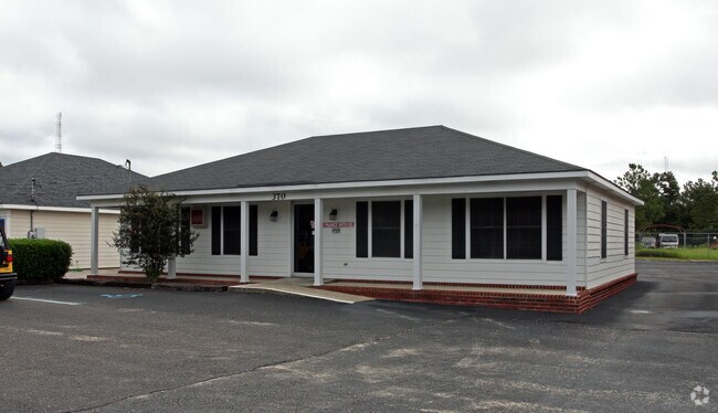
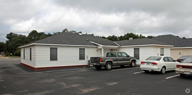
Property Record
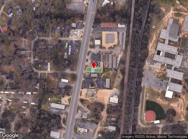
370 Saraland Blvd N, Saraland, AL 36571
NEARBY LISTINGS FOR SALE OR LEASE
Property Detail
370 Saraland Blvd N
19-08-33-0-001-008.005
Commercial Site
Officebuilding
COMM AT THE NW COR OF SEC 34 T2S R1W TH RUN E 660.0 FT TH S 1470.00 FT TH S 89 DEG 14 MIN E 862.15 FT TO A PT ON THE E ROW LINE OF US HWY 43 SD PT BEING ON THE ARC OF A CUR TO THE LEFT TH RUN SWL AND ALG A CHORD BEARING OF THE ARC OF SD CUR S 10 DEG
X
Mobile
01097C0429L
Alabama
2025
0.18 AC
2024
Outlying Mobile County
005602
Mobile
1,794 SF
Mobile, AL
DEMOGRAPHICS near 370 Saraland Blvd N
1 Mile
3 Mile
5 Mile
2024 Total Population
3,814
15,774
28,467
2029 Population
3,781
15,506
27,988
Pop Growth 2024-2029
(0.87%)
(1.70%)
(1.68%)
Average Age
39
39
40
2024 Total Households
1,474
6,128
11,079
HH Growth 2024-2029
(0.95%)
(1.75%)
(1.75%)
Median Household Inc
$57,799
$64,351
$58,222
Avg Household Size
2.60
2.60
2.60
2024 Avg HH Vehicles
2.00
2.00
2.00
Median Home Value
$141,869
$158,611
$161,092
Median Year Built
1972
1976
1975
Nearby Places
Map Layers
Map Styles
 Street
 Aerial
- Restaurants
- Banks
- Shops
- Fitness
- Groceries
PUBLIC TRANSPORTATION
AIRPORT
Mobile International
DRIVE
WALK
Distance
Mobile International
27 min
15.9 mi
Mobile Regional
DRIVE
WALK
Distance
Mobile Regional
35 min
19.7 mi
Freight Ports
Port of Mobile
DRIVE
WALK
Distance
Port of Mobile
17 min
10.6 mi
Nearby Properties
Address
Land Use
TOTAL SIZE
Lot Size
Zoning
Address
Land Use
TOTAL SIZE
Lot Size
Zoning
66,138 SF
35.24 AC
Address
Land Use
TOTAL SIZE
Lot Size
Zoning
9,100 SF
34.07 AC
Address
Land Use
TOTAL SIZE
Lot Size
Zoning
21,700 SF
6.98 AC
Address
Land Use
TOTAL SIZE
Lot Size
Zoning
197,471 SF
15.90 AC
Address
Land Use
TOTAL SIZE
Lot Size
Zoning
66,678 SF
2.29 AC
Address
Land Use
TOTAL SIZE
Lot Size
Zoning
57,084 SF
1.97 AC
Address
Land Use
TOTAL SIZE
Lot Size
Zoning
1,104 SF
6.01 AC
Address
Land Use
TOTAL SIZE
Lot Size
Zoning
116,512 SF
9.60 AC
Address
Land Use
TOTAL SIZE
Lot Size
Zoning
125,239 SF
11.20 AC
Address
Land Use
TOTAL SIZE
Lot Size
Zoning
35,952 SF
5.37 AC
Address
Land Use
TOTAL SIZE
Lot Size
Zoning
294,193 SF
7.06 AC
Address
Land Use
TOTAL SIZE
Lot Size
Zoning
18,818 SF
6.21 AC
Address
Land Use
TOTAL SIZE
Lot Size
Zoning
86,174 SF
9.30 AC
Address
Land Use
TOTAL SIZE
Lot Size
Zoning
114,942 SF
28.61 AC
Address
Land Use
TOTAL SIZE
Lot Size
Zoning
73,680 SF
27 AC
Address
Land Use
TOTAL SIZE
Lot Size
Zoning
128,250 SF
13.83 AC
Address
Land Use
TOTAL SIZE
Lot Size
Zoning
21,800 SF
6 AC
Address
Land Use
TOTAL SIZE
Lot Size
Zoning
76,682 SF
9.62 AC
Address
Land Use
TOTAL SIZE
Lot Size
Zoning
34,504 SF
12 AC
Address
Land Use
TOTAL SIZE
Lot Size
Zoning
50,740 SF
1.57 AC
Address
Land Use
TOTAL SIZE
Lot Size
Zoning
200,472 SF
9.18 AC
Address
Land Use
TOTAL SIZE
Lot Size
Zoning
55,927 SF
5.87 AC
Address
Land Use
TOTAL SIZE
Lot Size
Zoning
31,420 SF
3.54 AC
Address
Land Use
TOTAL SIZE
Lot Size
Zoning
21,600 SF
6.28 AC
Address
Land Use
TOTAL SIZE
Lot Size
Zoning
41,607 SF
2.96 AC
Address
Land Use
TOTAL SIZE
Lot Size
Zoning
14,688 SF
5.70 AC
Address
Land Use
TOTAL SIZE
Lot Size
Zoning
200,000 SF
Address
Land Use
TOTAL SIZE
Lot Size
Zoning
35,344 SF
1.42 AC
Address
Land Use
TOTAL SIZE
Lot Size
Zoning
41,061 SF
1.56 AC
Address
Land Use
TOTAL SIZE
Lot Size
Zoning
200,000 SF
4.54 AC
The World's #1 Commercial Real Estate Marketplace
Connect with us
© 2025 CoStar Group
The information above has been obtained from sources believed reliable. While we do not doubt its accuracy we have not verified it and make no guarantee, warranty or representation about it. It is your responsibility to independently confirm its accuracy and completeness. Any projections, opinions, assumptions, or estimates used are for example only and do not represent the current or future performance of the property. The value of this transaction to you depends on tax and other factors which should be evaluated by your tax, financial, and legal advisors. You and your advisors should conduct a careful, independent investigation of the property to determine to your satisfaction the suitability of the property for your needs.