Property Record
370 Stevers Crossing Rd, Philmont, NY 12565

NEARBY LISTINGS FOR SALE OR LEASE
-
-
View all Philmont listings for sale on LoopNet.com
Property Detail
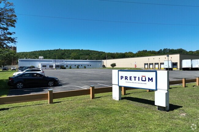
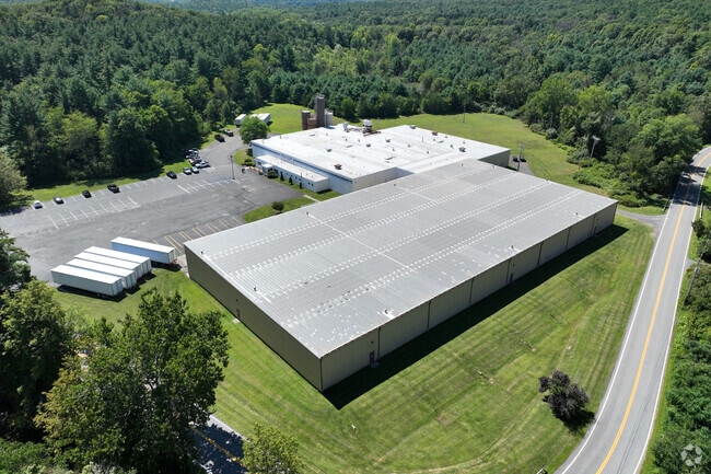
370 Stevers Crossing Rd
Hudson, NY
Columbia
102889-123-000-0002-020-000-0000
New York
Manufacturinglight
20.000
2025
37 AC
2024
Columbia County
001000
Albany/Schenectady/Troy
46,870 SF
DEMOGRAPHICS near 370 Stevers Crossing Rd
1 Mile
3 Mile
5 Mile
2024 Total Population
339
2,563
5,732
2029 Population
318
2,474
5,584
Pop Growth 2024-2029
(6.19%)
(3.47%)
(2.58%)
Average Age
46
44
46
2024 Total Households
135
1,040
2,409
HH Growth 2024-2029
(6.67%)
(3.65%)
(2.66%)
Median Household Inc
$50,294
$52,922
$65,196
Avg Household Size
2.30
2.30
2.30
2024 Avg HH Vehicles
1.00
2.00
2.00
Median Home Value
$209,375
$199,535
$267,733
Median Year Built
1956
1957
1968
Nearby Places
Map Layers
Map Styles
 Street
 Aerial
- Restaurants
- Banks
- Shops
- Fitness
- Groceries
Nearby Properties
Address
Land Use
TOTAL SIZE
Lot Size
Zoning
Address
Land Use
TOTAL SIZE
Lot Size
Zoning
54,688 SF
18.76 AC
07 - MIXED
Address
Land Use
TOTAL SIZE
Lot Size
Zoning
5,400 SF
34.40 AC
07 - MIXED
Address
Land Use
TOTAL SIZE
Lot Size
Zoning
28,248 SF
2 AC
07 - MIXED
Address
Land Use
TOTAL SIZE
Lot Size
Zoning
2,484 SF
3.40 AC
07 - MIXED
Address
Land Use
TOTAL SIZE
Lot Size
Zoning
4,500 SF
24.27 AC
RU C
Address
Land Use
TOTAL SIZE
Lot Size
Zoning
2,152 SF
89.80 AC
07 - MIXED
Address
Land Use
TOTAL SIZE
Lot Size
Zoning
2,960 SF
122.30 AC
07 - MIXED
Address
Land Use
TOTAL SIZE
Lot Size
Zoning
3,041 SF
67.70 AC
01 - NOT Z
Address
Land Use
TOTAL SIZE
Lot Size
Zoning
211.60 AC
07 - MIXED
Address
Land Use
TOTAL SIZE
Lot Size
Zoning
3,236 SF
128.57 AC
RA2
Address
Land Use
TOTAL SIZE
Lot Size
Zoning
2,400 SF
66.40 AC
07 - MIXED
Address
Land Use
TOTAL SIZE
Lot Size
Zoning
57,793 SF
36.70 AC
07 - MIXED
Address
Land Use
TOTAL SIZE
Lot Size
Zoning
6,992 SF
1.90 AC
07 - MIXED
Address
Land Use
TOTAL SIZE
Lot Size
Zoning
112.90 AC
01 - NOT Z
Address
Land Use
TOTAL SIZE
Lot Size
Zoning
106.90 AC
01 - NOT Z
Address
Land Use
TOTAL SIZE
Lot Size
Zoning
270.04 AC
4205
Address
Land Use
TOTAL SIZE
Lot Size
Zoning
4,099 SF
5 AC
RA2 C
Address
Land Use
TOTAL SIZE
Lot Size
Zoning
9,910 SF
1.06 AC
07 - MIXED
Address
Land Use
TOTAL SIZE
Lot Size
Zoning
41 AC
07 - MIXED
Address
Land Use
TOTAL SIZE
Lot Size
Zoning
5,725 SF
1.49 AC
07 - MIXED
Address
Land Use
TOTAL SIZE
Lot Size
Zoning
114.10 AC
07 - MIXED
Address
Land Use
TOTAL SIZE
Lot Size
Zoning
119.10 AC
07 - MIXED
Address
Land Use
TOTAL SIZE
Lot Size
Zoning
112 AC
07 - MIXED
Address
Land Use
TOTAL SIZE
Lot Size
Zoning
183 AC
07 - MIXED
Address
Land Use
TOTAL SIZE
Lot Size
Zoning
74.20 AC
01 - NOT Z
Address
Land Use
TOTAL SIZE
Lot Size
Zoning
3,214 SF
0.23 AC
07 - MIXED
Address
Land Use
TOTAL SIZE
Lot Size
Zoning
98.90 AC
07 - MIXED
Address
Land Use
TOTAL SIZE
Lot Size
Zoning
46.36 AC
07 - MIXED
Address
Land Use
TOTAL SIZE
Lot Size
Zoning
98.12 AC
07 - MIXED
The World's #1 Commercial Real Estate Marketplace
Connect with us
© 2025 CoStar Group
The information above has been obtained from sources believed reliable. While we do not doubt its accuracy we have not verified it and make no guarantee, warranty or representation about it. It is your responsibility to independently confirm its accuracy and completeness. Any projections, opinions, assumptions, or estimates used are for example only and do not represent the current or future performance of the property. The value of this transaction to you depends on tax and other factors which should be evaluated by your tax, financial, and legal advisors. You and your advisors should conduct a careful, independent investigation of the property to determine to your satisfaction the suitability of the property for your needs.