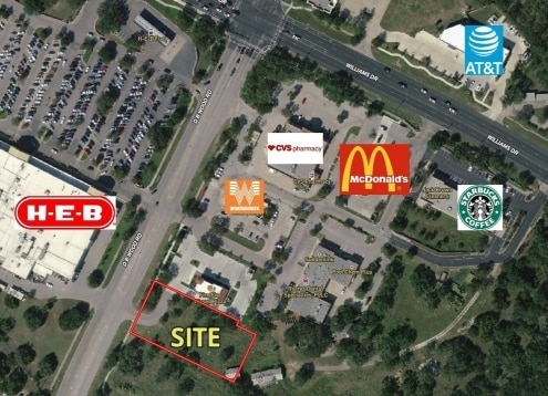
Property Record
3700 D B Wood Rd, Georgetown, TX 78628

Save to a Folder
{{folder.Name}}
{{folder.ListingIds.length}} Properties
{{folder.ListingIds.length}} Property
Create a New Folder
Property Detail
3700 D B Wood Rd
Austin-Round Rock-San Marcos, TX
S11743 - ECKERDS AT CEDAR BREAKS AMD RESUB (LTS 5A & 5B AMD), LOT 5-B1, ACRES 1.028
R568985
WILLIAMSON
Commercialnec
Texas
B and X Area of moderate flood hazard, usually the area between the limits of the 100-year and 500-year floods.
5-b1
2024
1.03 AC
2025
Georgetown
020111
Austin
46,430 SF
NEARBY LISTINGS FOR SALE OR LEASE
DEMOGRAPHICS near 3700 D B Wood Rd
1 mile
3 mile
5 mile
2025 Total Population
6,475
38,272
87,880
2030 Population
7,346
43,884
101,761
Pop Growth 2025-2030
+ 13.45%
+ 14.66%
+ 15.80%
Average Age
46
49
48
2025 Total Households
2,769
17,024
38,071
HH Growth 2025-2030
+ 13.87%
+ 15.05%
+ 16.17%
Median Household Inc
$122,990
$106,995
$102,545
Avg Household Size
2.30
2.20
2.20
2025 Avg HH Vehicles
2.00
2.00
2.00
Median Home Value
$493,622
$492,010
$485,904
Median Year Built
2009
2005
2007
Nearby Places
Map Layers
Map Styles
 Street
 Aerial
Layers
 Traffic
 Biking
Places
Listings with unknown addresses are not visible on the map
- Restaurants
- Banks
- Shops
- Fitness
- Groceries
PUBLIC TRANSPORTATION
AIRPORT
Killeen Municipal
Drive
Walk
Distance
Killeen Municipal
54 min
38.8 mi
Robert Gray AAF
Drive
Walk
Distance
Robert Gray AAF
58 min
39.7 mi
Freight Ports
Calhoun Port
Drive
Walk
Distance
Calhoun Port
218 min
190.4 mi
SALE & LEASE HISTORY
LISTING DATE
SALE/LEASE

Feb 22, 2022
For Sale
Nearby Properties
Address
Land Use
TOTAL SIZE
Lot Size
Zoning
Address
Land Use
TOTAL SIZE
Lot Size
Zoning
389,888 SF
30 AC
1-MF
Address
Land Use
TOTAL SIZE
Lot Size
Zoning
200,200 SF
34.02 AC
Address
Land Use
TOTAL SIZE
Lot Size
Zoning
310,849 SF
13.15 AC
Address
Land Use
TOTAL SIZE
Lot Size
Zoning
495,688 SF
20.31 AC
1-MF
Address
Land Use
TOTAL SIZE
Lot Size
Zoning
233,173 SF
9.89 AC
Address
Land Use
TOTAL SIZE
Lot Size
Zoning
282,472 SF
11.79 AC
Address
Land Use
TOTAL SIZE
Lot Size
Zoning
316,931 SF
3.02 AC
Address
Land Use
TOTAL SIZE
Lot Size
Zoning
241,804 SF
17.57 AC
3-C-3
Address
Land Use
TOTAL SIZE
Lot Size
Zoning
120,653 SF
12.83 AC
Address
Land Use
TOTAL SIZE
Lot Size
Zoning
186,337 SF
8.39 AC
Address
Land Use
TOTAL SIZE
Lot Size
Zoning
241,857 SF
26.60 AC
Address
Land Use
TOTAL SIZE
Lot Size
Zoning
592 SF
42.32 AC
Address
Land Use
TOTAL SIZE
Lot Size
Zoning
174,955 SF
9.28 AC
Address
Land Use
TOTAL SIZE
Lot Size
Zoning
90,821 SF
41.97 AC
Address
Land Use
TOTAL SIZE
Lot Size
Zoning
88,851 SF
11.06 AC
Address
Land Use
TOTAL SIZE
Lot Size
Zoning
176,065 SF
19.48 AC
Address
Land Use
TOTAL SIZE
Lot Size
Zoning
160,042 SF
10.15 AC
Address
Land Use
TOTAL SIZE
Lot Size
Zoning
129,281 SF
17.68 AC
Address
Land Use
TOTAL SIZE
Lot Size
Zoning
222,518 SF
4.20 AC
Address
Land Use
TOTAL SIZE
Lot Size
Zoning
123,984 SF
6.89 AC
Address
Land Use
TOTAL SIZE
Lot Size
Zoning
160,974 SF
10.62 AC
3-C-3
Address
Land Use
TOTAL SIZE
Lot Size
Zoning
50,543 SF
10.49 AC
Address
Land Use
TOTAL SIZE
Lot Size
Zoning
208,945 SF
23.56 AC
3-C-3
Address
Land Use
TOTAL SIZE
Lot Size
Zoning
64,344 SF
2.43 AC
Address
Land Use
TOTAL SIZE
Lot Size
Zoning
209,508 SF
13.25 AC
Address
Land Use
TOTAL SIZE
Lot Size
Zoning
84,198 SF
8.65 AC
3-C-3
Address
Land Use
TOTAL SIZE
Lot Size
Zoning
188,408 SF
9.62 AC
Address
Land Use
TOTAL SIZE
Lot Size
Zoning
192.21 AC
Address
Land Use
TOTAL SIZE
Lot Size
Zoning
185,240 SF
9.84 AC
Address
Land Use
TOTAL SIZE
Lot Size
Zoning
130,935 SF
7.79 AC
The World's #1 Commercial Real Estate Marketplace
Connect with us
© 2026 CoStar Group
The information above has been obtained from sources believed reliable. While we do not doubt its accuracy we have not verified it and make no guarantee, warranty or representation about it. It is your responsibility to independently confirm its accuracy and completeness. Any projections, opinions, assumptions, or estimates used are for example only and do not represent the current or future performance of the property. The value of this transaction to you depends on tax and other factors which should be evaluated by your tax, financial, and legal advisors. You and your advisors should conduct a careful, independent investigation of the property to determine to your satisfaction the suitability of the property for your needs.