Property Record
3700 N La Brea St, Eloy, AZ 85131

NEARBY LISTINGS FOR SALE OR LEASE
Property Detail
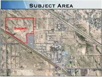
3700 N La Brea St
403-07-158H
COM @ N1/4 COR OF SEC 28-7S-7E TH S-591 TO POB TH CONT S-749.31 T H W-663.02 CONT W-25.08 TH S-1340.72 TH W-177.36 TO A PT N'LY R/W LINE OF INTERSTATE 10 TH N-53D W-ALONG R/W 2234.84 TO A PT ON W- LINE OF NW TH N-779.39 TH E-2653.98 TO POB 95.32 AC
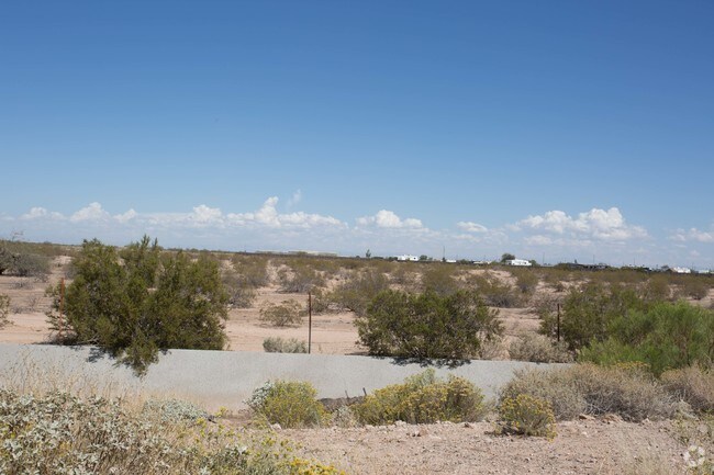
Vacantlandnec
Pinal
X
Arizona
04021C1570F
95.32 AC
2024
Pinal County
2025
Phoenix
001900
Phoenix-Mesa-Scottsdale, AZ
DEMOGRAPHICS near 3700 N La Brea St
1 Mile
3 Mile
5 Mile
2024 Total Population
373
9,142
25,990
2029 Population
478
11,906
33,646
Pop Growth 2024-2029
+ 28.15%
+ 30.23%
+ 29.46%
Average Age
36
49
44
2024 Total Households
123
3,852
10,097
HH Growth 2024-2029
+ 27.64%
+ 30.11%
+ 29.38%
Median Household Inc
$42,187
$59,950
$52,525
Avg Household Size
3.10
2.40
2.50
2024 Avg HH Vehicles
2.00
2.00
2.00
Median Home Value
$94,736
$299,683
$188,021
Median Year Built
1994
2009
2005
Nearby Places
Map Layers
Map Styles
 Street
 Aerial
- Restaurants
- Banks
- Shops
- Fitness
- Groceries
Nearby Properties
Address
Land Use
TOTAL SIZE
Lot Size
Zoning
Address
Land Use
TOTAL SIZE
Lot Size
Zoning
37,469 SF
20.01 AC
UNDESIGNAT
Address
Land Use
TOTAL SIZE
Lot Size
Zoning
11,382 SF
13.33 AC
Address
Land Use
TOTAL SIZE
Lot Size
Zoning
26,328 SF
22.85 AC
UNDESIGNAT
Address
Land Use
TOTAL SIZE
Lot Size
Zoning
27.14 AC
UNDESIGNAT
Address
Land Use
TOTAL SIZE
Lot Size
Zoning
Address
Land Use
TOTAL SIZE
Lot Size
Zoning
16,305 SF
43.90 AC
UNDESIGNAT
Address
Land Use
TOTAL SIZE
Lot Size
Zoning
35,964 SF
9.40 AC
UNDESIGNAT
Address
Land Use
TOTAL SIZE
Lot Size
Zoning
16,160 SF
11.88 AC
Address
Land Use
TOTAL SIZE
Lot Size
Zoning
Address
Land Use
TOTAL SIZE
Lot Size
Zoning
24,543 SF
2.28 AC
UNDESIGNAT
Address
Land Use
TOTAL SIZE
Lot Size
Zoning
46.81 AC
Address
Land Use
TOTAL SIZE
Lot Size
Zoning
53.77 AC
UNDESIGNAT
Address
Land Use
TOTAL SIZE
Lot Size
Zoning
30,420 SF
4.90 AC
CB2
Address
Land Use
TOTAL SIZE
Lot Size
Zoning
14,400 SF
40 AC
Address
Land Use
TOTAL SIZE
Lot Size
Zoning
23,640 SF
2.72 AC
Address
Land Use
TOTAL SIZE
Lot Size
Zoning
352 SF
22.81 AC
UNDESIGNAT
Address
Land Use
TOTAL SIZE
Lot Size
Zoning
16,393 SF
116.73 AC
UNDESIGNAT
Address
Land Use
TOTAL SIZE
Lot Size
Zoning
27,639 SF
2.82 AC
UNDESIGNAT
Address
Land Use
TOTAL SIZE
Lot Size
Zoning
239.09 AC
UNDESIGNAT
Address
Land Use
TOTAL SIZE
Lot Size
Zoning
9,390 SF
3.59 AC
UNDESIGNAT
Address
Land Use
TOTAL SIZE
Lot Size
Zoning
8,988 SF
0.93 AC
Address
Land Use
TOTAL SIZE
Lot Size
Zoning
49,682 SF
3.16 AC
CB2
Address
Land Use
TOTAL SIZE
Lot Size
Zoning
8,453 SF
2.95 AC
CB1
Address
Land Use
TOTAL SIZE
Lot Size
Zoning
13,442 SF
1.79 AC
UNDESIGNAT
Address
Land Use
TOTAL SIZE
Lot Size
Zoning
8,320 SF
0.90 AC
Address
Land Use
TOTAL SIZE
Lot Size
Zoning
16,100 SF
8.25 AC
CI2
Address
Land Use
TOTAL SIZE
Lot Size
Zoning
5,624 SF
11.15 AC
UNDESIGNAT
The World's #1 Commercial Real Estate Marketplace
Connect with us
© 2025 CoStar Group
The information above has been obtained from sources believed reliable. While we do not doubt its accuracy we have not verified it and make no guarantee, warranty or representation about it. It is your responsibility to independently confirm its accuracy and completeness. Any projections, opinions, assumptions, or estimates used are for example only and do not represent the current or future performance of the property. The value of this transaction to you depends on tax and other factors which should be evaluated by your tax, financial, and legal advisors. You and your advisors should conduct a careful, independent investigation of the property to determine to your satisfaction the suitability of the property for your needs.