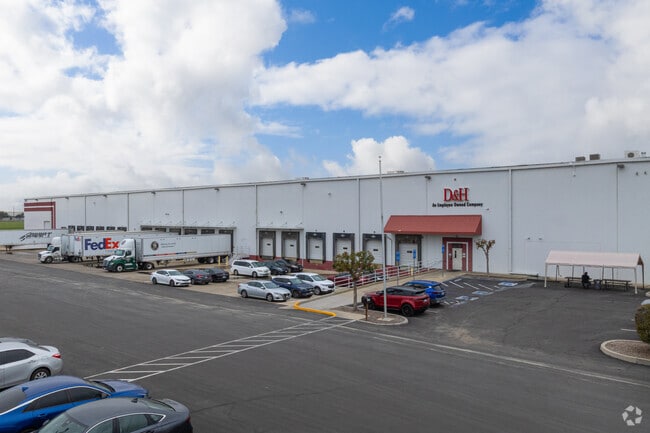
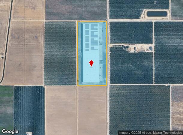
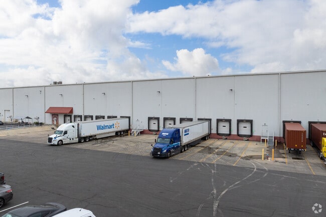
Property Record
3701 S Minnewawa Ave, Fresno, CA 93725

NEARBY LISTINGS FOR SALE OR LEASE
Property Detail
3701 S Minnewawa Ave
331-020-49S
SUR RT 18.77 AC IN N1/2 OF SW1/4 SEC 29 T14R21
Warehouse
Fresno
X
California
06019C2140H
18.77 AC
2025
Southeast Fresno
2025
Fresno
001500
Fresno, CA
410,925 SF
DEMOGRAPHICS near 3701 S Minnewawa Ave
1 Mile
3 Mile
5 Mile
2024 Total Population
177
29,377
127,031
2029 Population
175
29,855
129,692
Pop Growth 2024-2029
(1.13%)
+ 1.63%
+ 2.09%
Average Age
37
34
34
2024 Total Households
45
7,522
35,263
HH Growth 2024-2029
(2.22%)
+ 1.68%
+ 2.14%
Median Household Inc
$49,999
$77,845
$56,400
Avg Household Size
3.70
3.80
3.50
2024 Avg HH Vehicles
2.00
2.00
2.00
Median Home Value
$328,571
$321,887
$295,391
Median Year Built
1971
1998
1978
Nearby Places
Map Layers
Map Styles
 Street
 Aerial
- Restaurants
- Banks
- Shops
- Fitness
- Groceries
PUBLIC TRANSPORTATION
COMMUTER RAIL
DRIVE
WALK
Distance
14 min
7.6 mi
AIRPORT
Fresno Yosemite International
DRIVE
WALK
Distance
Fresno Yosemite International
15 min
6.9 mi
Nearby Properties
Address
Land Use
TOTAL SIZE
Lot Size
Zoning
Address
Land Use
TOTAL SIZE
Lot Size
Zoning
855,000 SF
63.99 AC
IH
Address
Land Use
TOTAL SIZE
Lot Size
Zoning
660,486 SF
39.04 AC
M3
Address
Land Use
TOTAL SIZE
Lot Size
Zoning
732,149 SF
77.34 AC
M3
Address
Land Use
TOTAL SIZE
Lot Size
Zoning
50,450 SF
16.84 AC
M3
Address
Land Use
TOTAL SIZE
Lot Size
Zoning
396,353 SF
34.78 AC
M3
Address
Land Use
TOTAL SIZE
Lot Size
Zoning
511,500 SF
22.55 AC
M3
Address
Land Use
TOTAL SIZE
Lot Size
Zoning
12,088 SF
23.62 AC
M3
Address
Land Use
TOTAL SIZE
Lot Size
Zoning
84,376 SF
20 AC
AE20
Address
Land Use
TOTAL SIZE
Lot Size
Zoning
514,976 SF
24.18 AC
M3
Address
Land Use
TOTAL SIZE
Lot Size
Zoning
202,038 SF
10.83 AC
IH
Address
Land Use
TOTAL SIZE
Lot Size
Zoning
524,298 SF
22.08 AC
M3
Address
Land Use
TOTAL SIZE
Lot Size
Zoning
267,104 SF
64.16 AC
M3
Address
Land Use
TOTAL SIZE
Lot Size
Zoning
147,840 SF
8.55 AC
M3
Address
Land Use
TOTAL SIZE
Lot Size
Zoning
425,074 SF
15.69 AC
M3
Address
Land Use
TOTAL SIZE
Lot Size
Zoning
150,614 SF
17.30 AC
M3
Address
Land Use
TOTAL SIZE
Lot Size
Zoning
326,400 SF
17.03 AC
M1
Address
Land Use
TOTAL SIZE
Lot Size
Zoning
150,000 SF
13 AC
M1
Address
Land Use
TOTAL SIZE
Lot Size
Zoning
488,959 SF
21.41 AC
M3
Address
Land Use
TOTAL SIZE
Lot Size
Zoning
65,076 SF
5.33 AC
M3
Address
Land Use
TOTAL SIZE
Lot Size
Zoning
38,398 SF
14.24 AC
M3
Address
Land Use
TOTAL SIZE
Lot Size
Zoning
297,024 SF
14.94 AC
M3
Address
Land Use
TOTAL SIZE
Lot Size
Zoning
48,941 SF
38.19 AC
AE20
Address
Land Use
TOTAL SIZE
Lot Size
Zoning
249,600 SF
10.89 AC
M3
Address
Land Use
TOTAL SIZE
Lot Size
Zoning
9,000 SF
6.52 AC
M3
Address
Land Use
TOTAL SIZE
Lot Size
Zoning
300,240 SF
17.14 AC
M3
Address
Land Use
TOTAL SIZE
Lot Size
Zoning
81,730 SF
3.58 AC
M3
Address
Land Use
TOTAL SIZE
Lot Size
Zoning
252,130 SF
13.42 AC
M3
Address
Land Use
TOTAL SIZE
Lot Size
Zoning
114,978 SF
10.49 AC
IH
Address
Land Use
TOTAL SIZE
Lot Size
Zoning
113,664 SF
7.79 AC
M3
The World's #1 Commercial Real Estate Marketplace
Connect with us
© 2026 CoStar Group
The information above has been obtained from sources believed reliable. While we do not doubt its accuracy we have not verified it and make no guarantee, warranty or representation about it. It is your responsibility to independently confirm its accuracy and completeness. Any projections, opinions, assumptions, or estimates used are for example only and do not represent the current or future performance of the property. The value of this transaction to you depends on tax and other factors which should be evaluated by your tax, financial, and legal advisors. You and your advisors should conduct a careful, independent investigation of the property to determine to your satisfaction the suitability of the property for your needs.