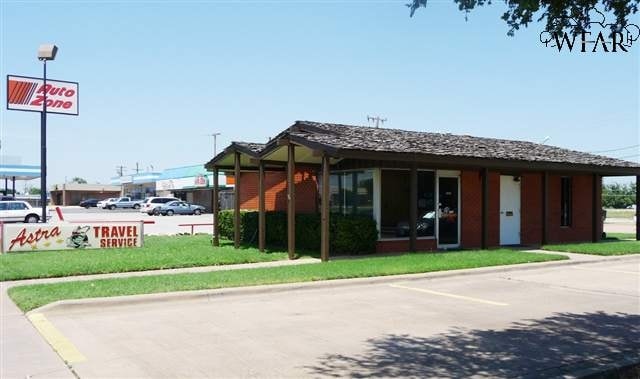
Property Record
3701 Sheppard Access Rd, Wichita Falls, TX 76306

Property Detail
3701 Sheppard Access Rd
123750
0.20 AC A-344 - T. C.
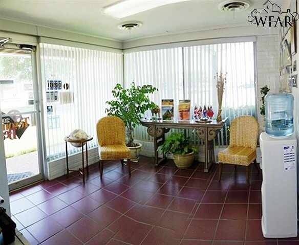
Officebuilding
Wichita
GC
Texas
B and X Area of moderate flood hazard, usually the area between the limits of the 100-year and 500-year floods.
0.20 AC
2024
North Wichita Falls
2025
Other Market Areas
013201
Wichita Falls, TX
918 SF
NEARBY LISTINGS FOR SALE OR LEASE
DEMOGRAPHICS near 3701 Sheppard Access Rd
1 mile
3 mile
5 mile
2025 Total Population
3,645
25,020
49,695
2030 Population
3,683
25,705
50,594
Pop Growth 2025-2030
+ 1.04%
+ 2.74%
+ 1.81%
Average Age
35
33
36
2025 Total Households
1,493
8,442
18,488
HH Growth 2025-2030
+ 1.27%
+ 4.02%
+ 2.29%
Median Household Inc
$56,730
$49,037
$48,027
Avg Household Size
2.30
2.30
2.30
2025 Avg HH Vehicles
2.00
2.00
2.00
Median Home Value
$73,433
$96,703
$95,710
Median Year Built
1976
1978
1965
Nearby Places
Map Layers
Map Styles
 Street
 Aerial
Transit
 Traffic
 Biking
Places
Listings with unknown addresses are not visible on the map
- Restaurants
- Banks
- Shops
- Fitness
- Groceries
SALE & LEASE HISTORY
LISTING DATE
SALE/LEASE

Sep 25, 2016
For Lease
Apr 27, 2022
For Lease
Nearby Properties
Address
Land Use
TOTAL SIZE
Lot Size
Zoning
Address
Land Use
TOTAL SIZE
Lot Size
Zoning
1,809,480 SF
132.45 AC
Address
Land Use
TOTAL SIZE
Lot Size
Zoning
4,501.47 AC
Address
Land Use
TOTAL SIZE
Lot Size
Zoning
233,084 SF
44.31 AC
SF2
Address
Land Use
TOTAL SIZE
Lot Size
Zoning
158,784 SF
69.19 AC
Address
Land Use
TOTAL SIZE
Lot Size
Zoning
80,294 SF
9.17 AC
Address
Land Use
TOTAL SIZE
Lot Size
Zoning
120,073 SF
17.43 AC
Address
Land Use
TOTAL SIZE
Lot Size
Zoning
101,451 SF
11.91 AC
RMU
Address
Land Use
TOTAL SIZE
Lot Size
Zoning
86,163 SF
10.89 AC
SF2
Address
Land Use
TOTAL SIZE
Lot Size
Zoning
95,337 SF
23.04 AC
Address
Land Use
TOTAL SIZE
Lot Size
Zoning
131,525 SF
4,501.50 AC
Address
Land Use
TOTAL SIZE
Lot Size
Zoning
183,184 SF
21.89 AC
GC
Address
Land Use
TOTAL SIZE
Lot Size
Zoning
143,878 SF
20.85 AC
MFR
Address
Land Use
TOTAL SIZE
Lot Size
Zoning
64,637 SF
25.40 AC
Address
Land Use
TOTAL SIZE
Lot Size
Zoning
115,654 SF
9.70 AC
Address
Land Use
TOTAL SIZE
Lot Size
Zoning
57,158 SF
2.04 AC
GC
Address
Land Use
TOTAL SIZE
Lot Size
Zoning
50,796 SF
2.65 AC
Address
Land Use
TOTAL SIZE
Lot Size
Zoning
42,505 SF
6.37 AC
MFR
Address
Land Use
TOTAL SIZE
Lot Size
Zoning
96,048 SF
7.92 AC
Address
Land Use
TOTAL SIZE
Lot Size
Zoning
136,370 SF
25.11 AC
RDD
Address
Land Use
TOTAL SIZE
Lot Size
Zoning
8,212 SF
6.54 AC
LI
Address
Land Use
TOTAL SIZE
Lot Size
Zoning
43,827 SF
1.82 AC
GC
Address
Land Use
TOTAL SIZE
Lot Size
Zoning
140,831 SF
8.36 AC
Address
Land Use
TOTAL SIZE
Lot Size
Zoning
52,024 SF
1.75 AC
GC
Address
Land Use
TOTAL SIZE
Lot Size
Zoning
75,722 SF
5.23 AC
Address
Land Use
TOTAL SIZE
Lot Size
Zoning
126,750 SF
10 AC
Address
Land Use
TOTAL SIZE
Lot Size
Zoning
49,700 SF
5.28 AC
Address
Land Use
TOTAL SIZE
Lot Size
Zoning
71,688 SF
7.52 AC
GC
Address
Land Use
TOTAL SIZE
Lot Size
Zoning
50,138 SF
2.61 AC
Address
Land Use
TOTAL SIZE
Lot Size
Zoning
19,905 SF
6.48 AC
Address
Land Use
TOTAL SIZE
Lot Size
Zoning
36,832 SF
7.08 AC
GC
The World's #1 Commercial Real Estate Marketplace
Connect with us
© 2026 CoStar Group
The information above has been obtained from sources believed reliable. While we do not doubt its accuracy we have not verified it and make no guarantee, warranty or representation about it. It is your responsibility to independently confirm its accuracy and completeness. Any projections, opinions, assumptions, or estimates used are for example only and do not represent the current or future performance of the property. The value of this transaction to you depends on tax and other factors which should be evaluated by your tax, financial, and legal advisors. You and your advisors should conduct a careful, independent investigation of the property to determine to your satisfaction the suitability of the property for your needs.